In 2024, the PPMN is unable to generate Wind Trajectory summaries.
Historically, the PPMN posted wind trajectory reports through collaboration between Agriculture and Agri-Food Canada and Environment and Climate Change Canada. Trajectories originating over northwestern and southern USA and Mexico – anywhere diamondback moth populations exist year-round and from which adults may actively migrate from were followed, summarized, and reported.
‘Reverse trajectories’ refer to air currents that are tracked back in time from specified Canadian locations over a five-day period prior to their arrival date. Of particular interest are those trajectories that, prior to their arrival in Canada, originated over northwestern and southern USA and Mexico, anywhere diamondback moth populations overwinter and adults are actively migrating. If diamondback adults are present in the air currents that originate from these southern locations, the moths may be deposited on the Prairies at sites along the trajectory, depending on the local weather conditions at the time that the trajectories pass over our area (e.g., rain showers, etc.). Reverse trajectories are the best available estimate of the ”true” 3D wind fields at a specific point. They are based on observations, satellite and radiosonde data.
Mexico, California and Texas: This week (June 14 – 20, 2023), no reverse trajectories originating over Mexico, California, or Texas, were predicted to pass over the prairies.
Pacific Northwest (Idaho, Oregon, Washington): This week, 90 reverse trajectories were predicted to cross the prairies. The majority of Pacific Northwest reverse trajectories were reported to pass over Alberta and western Saskatchewan (Fig. 1).
Figure 1. Total number of dates with reverse trajectories originating over the Idaho, Oregon, and Washington that have crossed the prairies between April 1 and June 20, 2023.
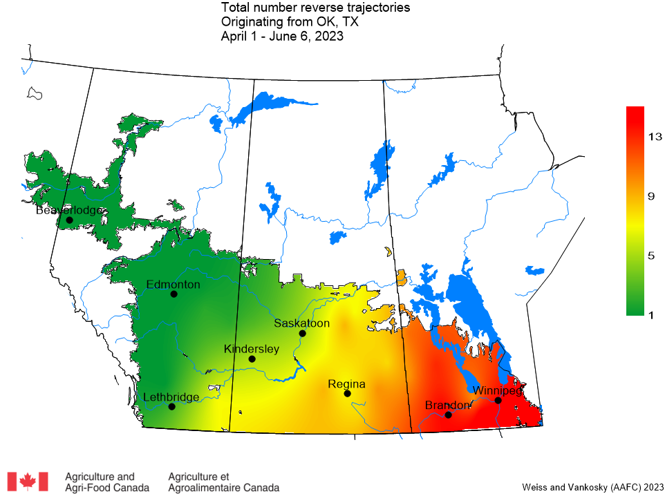
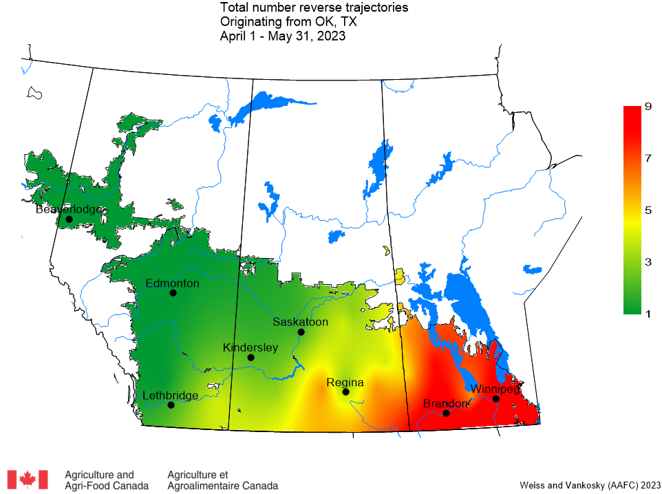
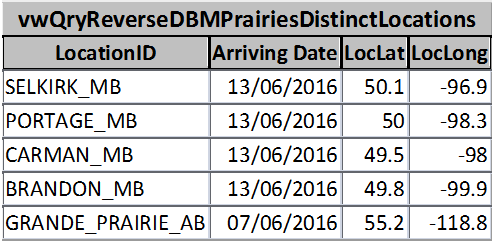
Oklahoma and Texas: This week only one (1) reverse trajectory that originated over Texas and Oklahoma was predicted to pass through the prairies, near Selkirk, Manitoba (Fig. 2).
Figure 2. The total number of dates with reverse trajectories originating over Oklahoma and Texas that have crossed the prairies between April 1 and June 20, 2023.
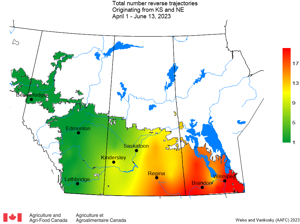
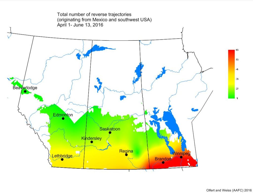
Kansas and Nebraska: This week there were 9 reverse trajectories, originating over Kansas and Nebraska, that were predicted to pass over Saskatchewan and Manitoba (Fig. 3).
Figure 3. The total number of dates with reverse trajectories originating over Kansas and Nebraska that have crossed the prairies between April 1 and June 20, 2023.
‘Reverse trajectories’ refer to air currents that are tracked back in time from specified Canadian locations over a five-day period prior to their arrival date. Of particular interest are those trajectories that, prior to their arrival in Canada, originated over northwestern and southern USA and Mexico, anywhere diamondback moth populations overwinter and adults are actively migrating. If diamondback adults are present in the air currents that originate from these southern locations, the moths may be deposited on the Prairies at sites along the trajectory, depending on the local weather conditions at the time that the trajectories pass over our area (e.g., rain showers, etc.). Reverse trajectories are the best available estimate of the ”true” 3D wind fields at a specific point. They are based on observations, satellite and radiosonde data.
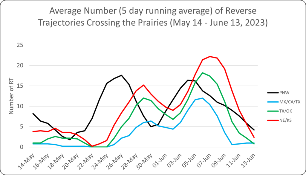
There was a significant decrease in the number of reverse trajectories that entered the Canadian prairies during the week of June 7-13, 2023 as compared to the previous week (Fig. 1).
Figure 1. The average number (based on a 5-day running average) of reverse trajectories (RT) that have crossed the prairies for the period of May 14 to June 13, 2023.
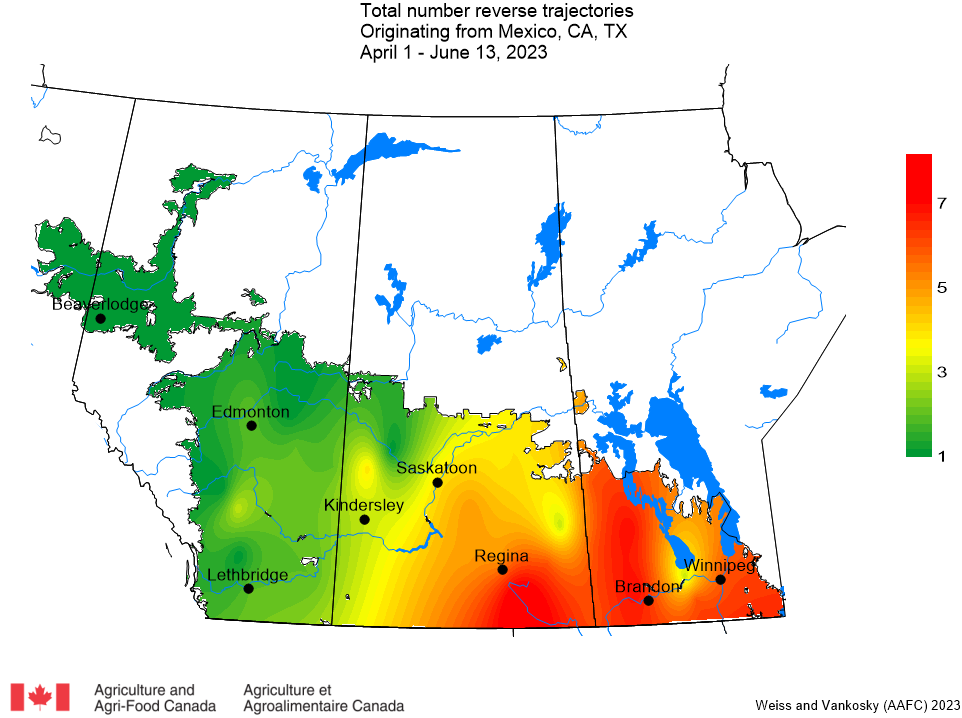
Mexico, California and Texas: Only 5 reverse trajectories crossed into the prairies from Mexico, California, and Texas from June 7-13. These trajectories were expected to cross into southeastern Saskatchewan and Manitoba (Fig. 2).
Figure 2. Total number of dates with reverse trajectories originating over Mexico, California and Texas that have crossed the prairies between April 1 and June 13, 2023.
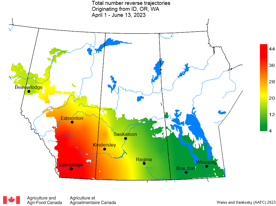
Pacific Northwest (Idaho, Oregon, Washington): This week 40 reverse trajectories were predicted to cross the prairies from the Pacific Northwest. The majority of the reverse trajectories from the Pacific Northwest passed over Alberta and western Saskatchewan (Fig. 3).
Figure 3. Total number of dates with reverse trajectories originating over the Idaho, Oregon, and Washington that have crossed the prairies between April 1 and June 13, 2023.
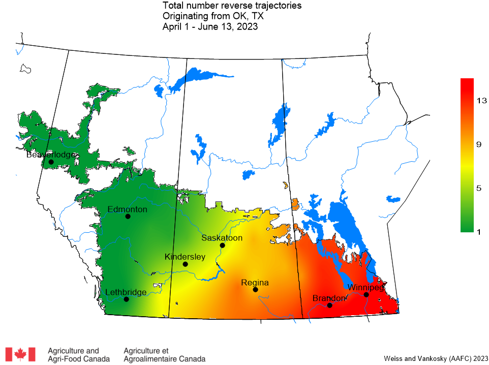
Oklahoma and Texas: There were 17 reverse trajectories that originated over Texas and Oklahoma and passed through the prairies in the past week. These reverse trajectories largely passed over Manitoba and southeastern Saskatchewan and (Fig. 4).
Figure 4. The total number of dates with reverse trajectories originating over Oklahoma and Texas that have crossed the prairies between May 1 and June 13, 2023.
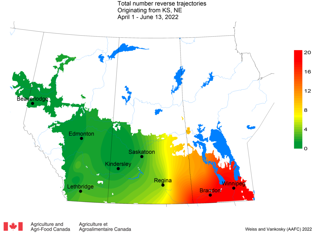
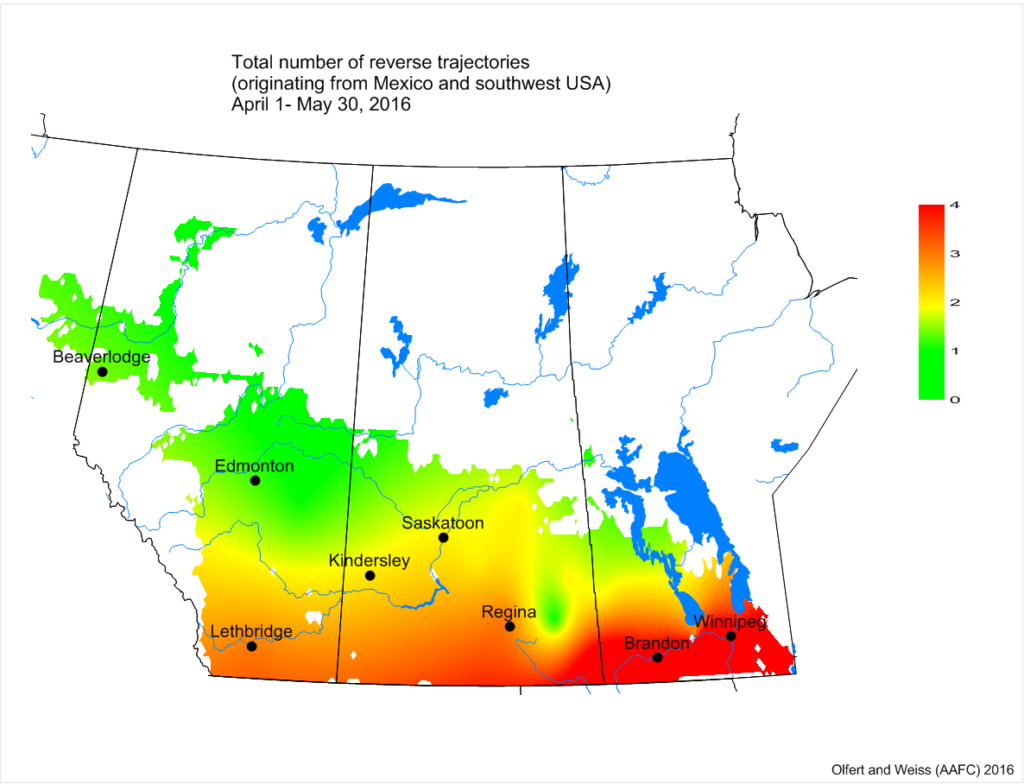
Kansas and Nebraska: Since April 1, reverse trajectories originating in Kansas and Nebraska were reported to cross southeastern Saskatchewan and southern Manitoba (Fig. 5). This week (June 7-13), there were 46 reverse trajectories, originating over Kansas and Nebraska that were predicted to pass over Saskatchewan and Manitoba.
Figure 5. The total number of dates with reverse trajectories originating over Kansas and Nebraska that have crossed the prairies between May 1 and June 13, 2023.
‘Reverse trajectories’ refer to air currents that are tracked back in time from specified Canadian locations over a five-day period prior to their arrival date. Of particular interest are those trajectories that, prior to their arrival in Canada, originated over northwestern and southern USA and Mexico, anywhere diamondback moth populations overwinter and adults are actively migrating. If diamondback adults are present in the air currents that originate from these southern locations, the moths may be deposited on the Prairies at sites along the trajectory, depending on the local weather conditions at the time that the trajectories pass over our area (e.g., rain showers, etc.). Reverse trajectories are the best available estimate of the ”true” 3D wind fields at a specific point. They are based on observations, satellite and radiosonde data.
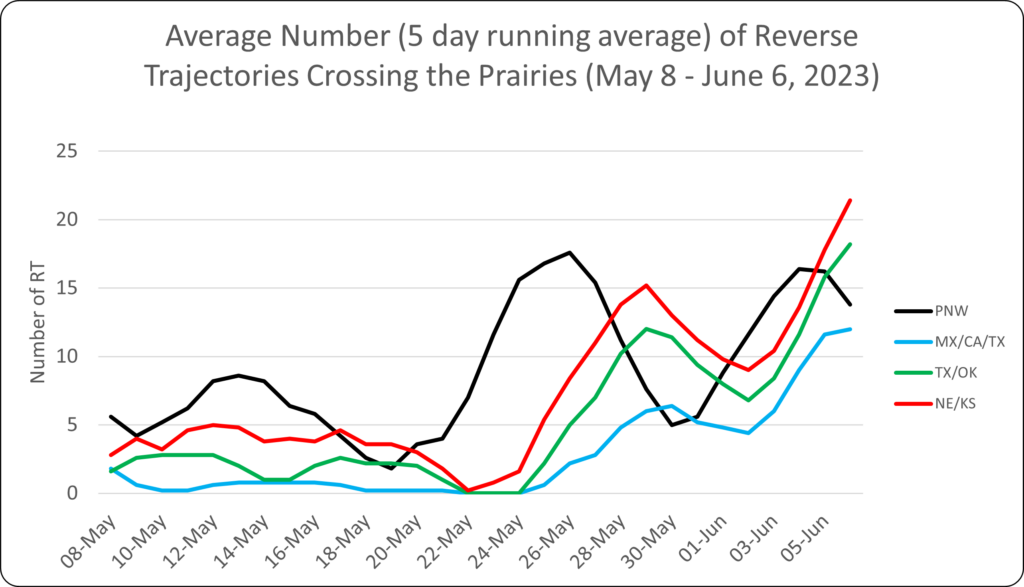
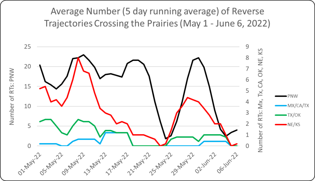
Relative to the previous two weeks, there was a significant increase in the number of reverse trajectories that entered the Canadian prairies between May 31 and June 6, 2023 (Fig. 1). This week, most of the reverse trajectories that crossed the prairies originated from the Great Plains (Nebraska, Kansas, Texas, Oklahoma). In earlier weeks of this growing season, most of the reverse trajectories originated from the Pacific Northwest. The number of reverse trajectories originating from California and Mexico also significantly increased in the last week. These results may indicate potential introductions of diamondback moth and leafhoppers to the prairies.
Figure 1. The average number (based on a 5-day running average) of reverse trajectories (RT) that have crossed the prairies for the period of May 8 to June 6, 2023.
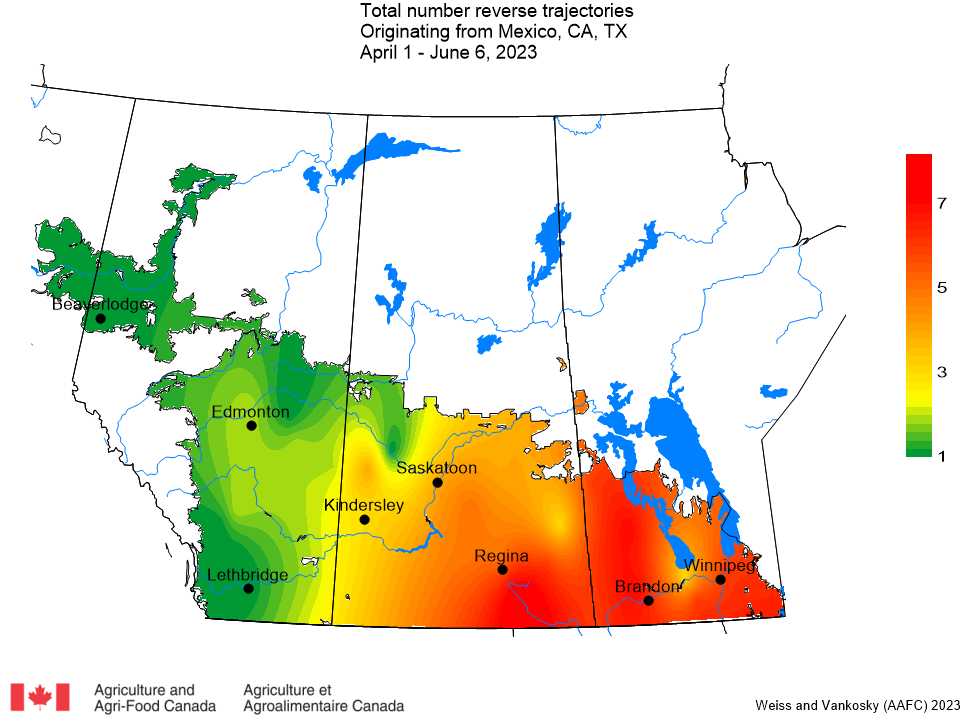
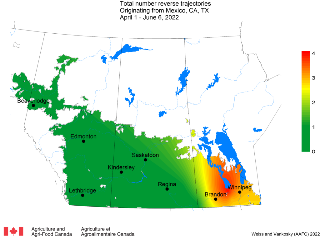
Mexico, California and Texas: This week, 63 reverse trajectories crossed into the prairies from Mexico and the US southwest. These trajectories were predicted to cross into southeastern Saskatchewan and Manitoba (Fig. 2)
Figure 2. Total number of dates with reverse trajectories originating over Mexico, California and Texas that have crossed the prairies between April 1 and June 6, 2023.
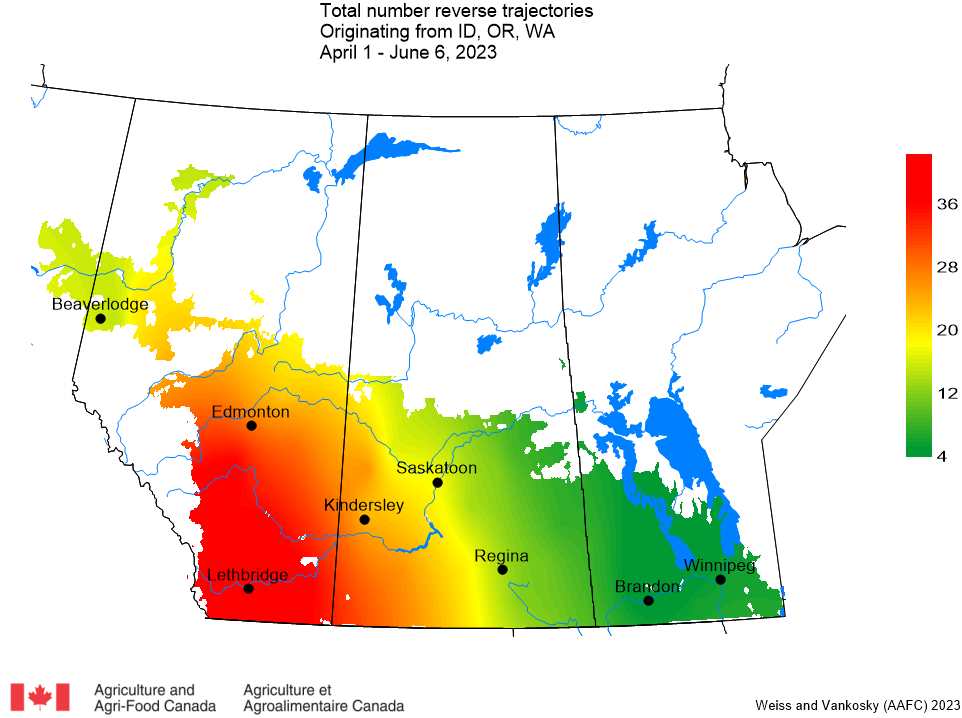
Pacific Northwest (Idaho, Oregon, Washington): This week 104 reverse trajectories were predicted to cross the prairies, with the majority of Pacific Northwest reverse trajectories reported to pass over Alberta and western Saskatchewan (Fig. 3).
Figure 3. Total number of dates with reverse trajectories originating over the Idaho, Oregon, and Washington that have crossed the prairies between April 1 and June 6, 2023.
Oklahoma and Texas: In the last week, 98 reverse trajectories that originated over Texas and Oklahoma passed through the prairies, particularly through Manitoba and southeastern Saskatchewan and (Fig. 4).
Figure 4. The total number of dates with reverse trajectories originating over Oklahoma and Texas that have crossed the prairies between May 1 and June 6, 2023.
Kansas and Nebraska: Between May 31 and June 6, 2023 there were 119 reverse trajectories have been reported that originated in Kansas and Nebraska and passed over southeastern Saskatchewan and southern Manitoba (Fig. 5).
Figure 5. The total number of dates with reverse trajectories originating over Kansas and Nebraska that have crossed the prairies between May 1 and June 6, 2023.
‘Reverse trajectories’ refer to air currents that are tracked back in time from specified Canadian locations over a five-day period prior to their arrival date. Of particular interest are those trajectories that, prior to their arrival in Canada, originated over northwestern and southern USA and Mexico, anywhere diamondback moth populations overwinter and adults are actively migrating. If diamondback moth adults are present in the air currents that originate from these southern locations, the moths may be deposited on the Prairies at sites along the trajectory, depending on the local weather conditions at the time that the trajectories pass over our area (e.g., rain showers, etc.). Reverse trajectories are the best available estimate of the ”true” 3D wind fields at a specific point. They are based on observations, satellite and radiosonde data.
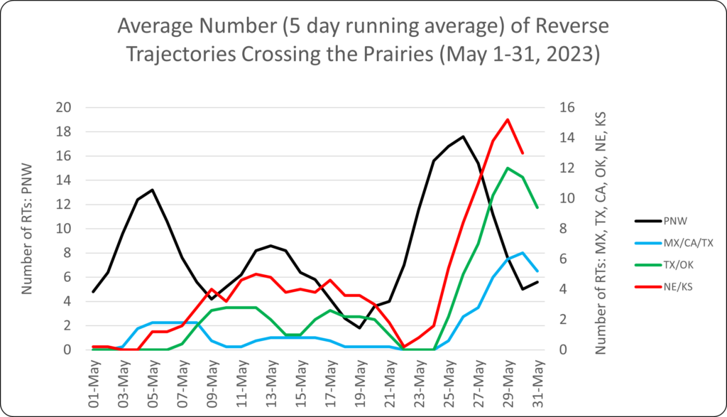
More reverse trajectories entered the Canadian prairies between May 25-31 than in the last two weeks (Fig. 1). With more reverse trajectories occurring, we may also see an increase in the introduction or migration of diamondback moths and aster leafhoppers to the prairies.
Figure 1. The average number (based on a 5-day running average) of reverse trajectories (RT) that have crossed the prairies for the period of May 1-31, 2023.
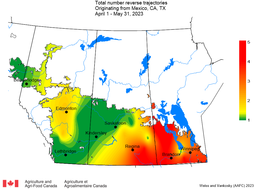
Mexico, California and Texas: Last week no reverse trajectories that entered the prairies that originated from Mexico, California or Texas. In comparison, 37 reverse trajectories from Mexico, California, or Texas crossed into the prairies this week (May 25-31). These trajectories were predicted to cross into southeastern Saskatchewan and Manitoba (Fig. 2)
Figure 2. Total number of dates with reverse trajectories originating over Mexico, California and Texas that have crossed the prairies between April 1 and May 31, 2023.
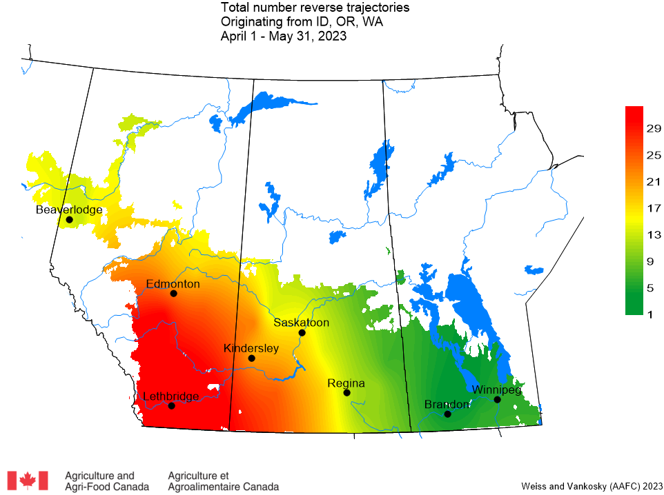
Pacific Northwest (Idaho, Oregon, Washington): This week 55 reverse trajectories from the Pacific Northwest were predicted to cross the prairies, which is less than observed last week (n=79). The majority of Pacific Northwest reverse trajectories have been reported to pass over Alberta and western Saskatchewan (Fig. 3).
Figure 3. Total number of dates with reverse trajectories originating over Idaho, Oregon, and Washington that have crossed the prairies between April 1 and May 31, 2023.
Oklahoma and Texas: This past week there were 38 reverse trajectories that originated over Texas and Oklahoma and passed through the prairies, particularly southeastern Saskatchewan and Manitoba (Fig. 4).
Figure 4. The total number of dates with reverse trajectories originating over Oklahoma and Texas that have crossed the prairies between May 1 and May 31, 2023.
Kansas and Nebraska: Since April 1, reverse trajectories originating in Kansas and Nebraska were reported to cross southeastern Saskatchewan and southern Manitoba (Fig. 5). Between May 25 and May 31, 2023 there were 95 reverse trajectories that were predicted to occur. This is a significant increase over the previous week (n=9).
Figure 5. The total number of dates with reverse trajectories originating over Kansas and Nebraska that have crossed the prairies between May 1 and May 31, 2023.
Agriculture and Agri-Food Canada (AAFC; Ross Weiss, Meghan Vankosky) and Environment and Climate Change Canada (ECCC; Serge Trudel) have been working together to study the potential of trajectories for monitoring insect movements since the late 1990s. Trajectory models are used to deliver an early-warning system for the origin and destination of migratory invasive species, such as diamondback moth.
‘Reverse trajectories’ refer to air currents that are tracked back in time from specified Canadian locations over a five-day period prior to their arrival date. Of particular interest are those trajectories that, prior to their arrival in Canada, originated over northwestern and southern USA and Mexico, anywhere diamondback moth populations overwinter and adults are actively migrating. If diamondback moth adults are present in the air currents that originate from these southern locations, the moths may be deposited on the Prairies at sites along the trajectory, depending on the local weather conditions at the time that the trajectories pass over our area (e.g., rain showers, etc.). Reverse trajectories are the best available estimate of the ”true” 3D wind fields at a specific point. They are based on observations, satellite and radiosonde data.
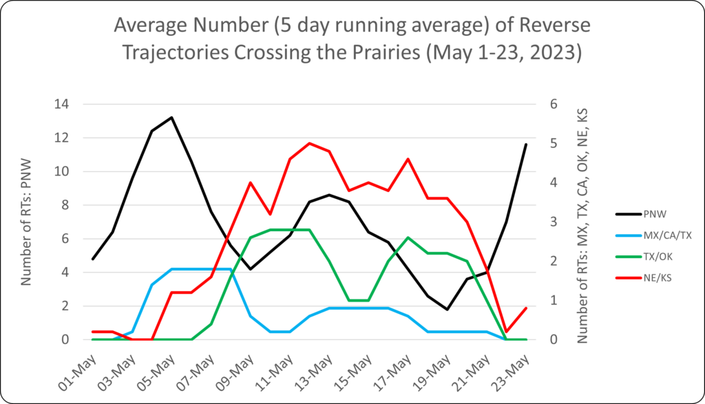
Wind Trajectories, May 1 to May 23, 2023:
Since May 1, 2023, the majority of reverse trajectories that have crossed the prairies originated from the Pacific Northwest (Idaho, Oregon and Washington) (Fig. 1). Very few reverse trajectories that originated in Mexico, California or Texas passed over the Canadian prairies between May 1 and May 23. No reverse trajectories, originating over Oklahoma or Texas crossed over the prairies this week.
Figure 1. The average number (based on a 5-day running average) of reverse trajectories (RT) that have crossed the prairies for the period of May 1-23, 2023.
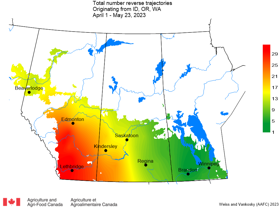
The majority of reverse trajectories originating in the Pacific Northwest have been reported to pass over south-central Alberta and southwestern Saskatchewan (Fig. 2).
Figure 2. Total number of dates with reverse trajectories originating over the Idaho, Oregon, and Washington that have crossed the prairies between April 1 and May 23, 2023.
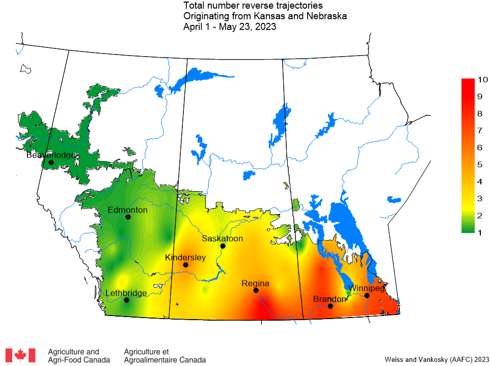
Since April 1, reverse trajectories that originated in Kansas and Nebraska were reported to cross southeastern Saskatchewan and southern Manitoba (Fig. 3).
Figure 3. The total number of dates with reverse trajectories originating over Kansas and Nebraska that have crossed the prairies between May 1 and May 23, 2023.
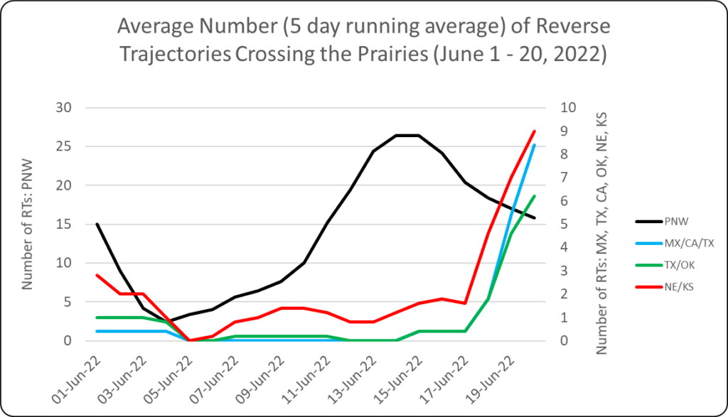
1. REVERSE TRAJECTORIES (RT) Since May 1, 2022, the majority of reverse trajectories that have crossed the prairies have originated from the Pacific Northwest (Idaho, Oregon and Washington). This past week (June 21-27, 2022) the number of incoming trajectories was lower than the week of June 14-20, 2022 (Fig. 1).
Figure 1. Average number (based on a 5-day running average) of reverse trajectories (RT) crossing the prairies for the period of June 1-27, 2022.
a. Pacific Northwest (Idaho, Oregon, Washington) – The majority of Pacific Northwest reverse trajectories continue to pass over southern and central Alberta and western Saskatchewan (Fig. 2). This past week (June 21-27, 2022) the ECCC model predicted that 77 reverse trajectories would cross the prairies. This is significantly less than the number of reverse trajectories predicted for the period of June 14-20 (n=124).
Figure 2. Total number of dates with reverse trajectories originating over the Idaho, Oregon, and Washington that have crossed the prairies between April 1 and June 27, 2022.
b. Mexico and southwest USA (Texas, California) – This week (June 21-27, 2022), a total of 13 reverse trajectories were predicted to cross the prairies (n=44 for June 14-20). Most reverse trajectories from this region of southern North America have crossed Manitoba during the 2022 growing season.
Figure 3. The total number of dates with reverse trajectories originating over Mexico, California and Texas that have crossed the prairies between April 1 and June 27, 2022.
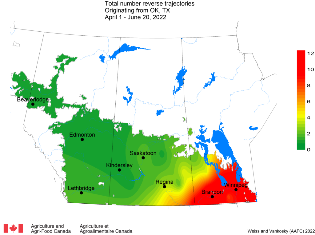
c. Oklahoma and Texas – This week reverse trajectories have passed over Manitoba and Watrous, Saskatchewan (Fig. 4). This week there were significantly fewer (n=5) reverse trajectories than for the period of June 14-20, 2022 (n=33).
Figure 4. The total number of dates with reverse trajectories originating over Texas and Oklahoma that have crossed the prairies between May 1 and June 27, 2022.
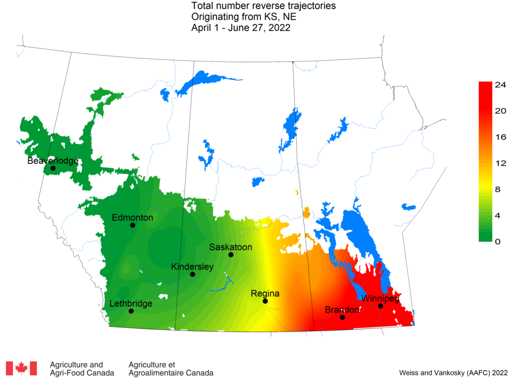
d. Nebraska and Kansas – This past week (June 21-27, 2022), reverse trajectories originating from Kansas and Nebraska have crossed Manitoba and Yorkton, Saskatchewan (Fig. 5). The ECCC model predicted that 5 reverse trajectories passed over the prairies. This is a significant decrease from the previous week (n=51).
Figure 5. The total number of dates with reverse trajectories originating over Kansas and Nebraska that have crossed the prairies between April 1 and June 27, 2022.
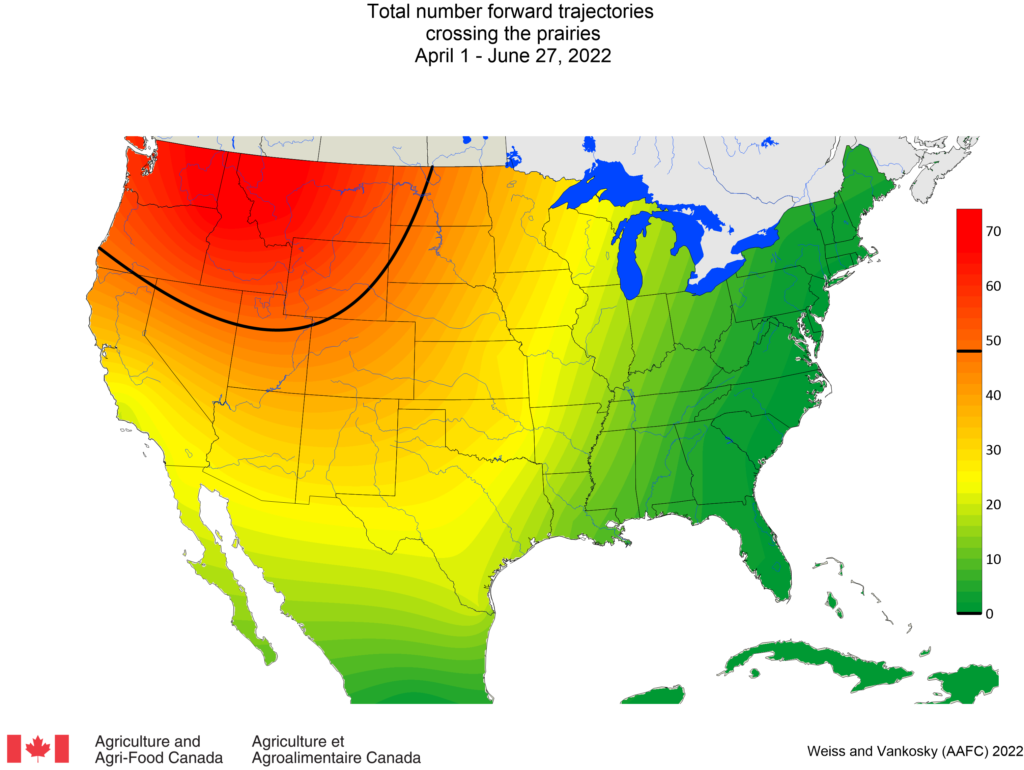
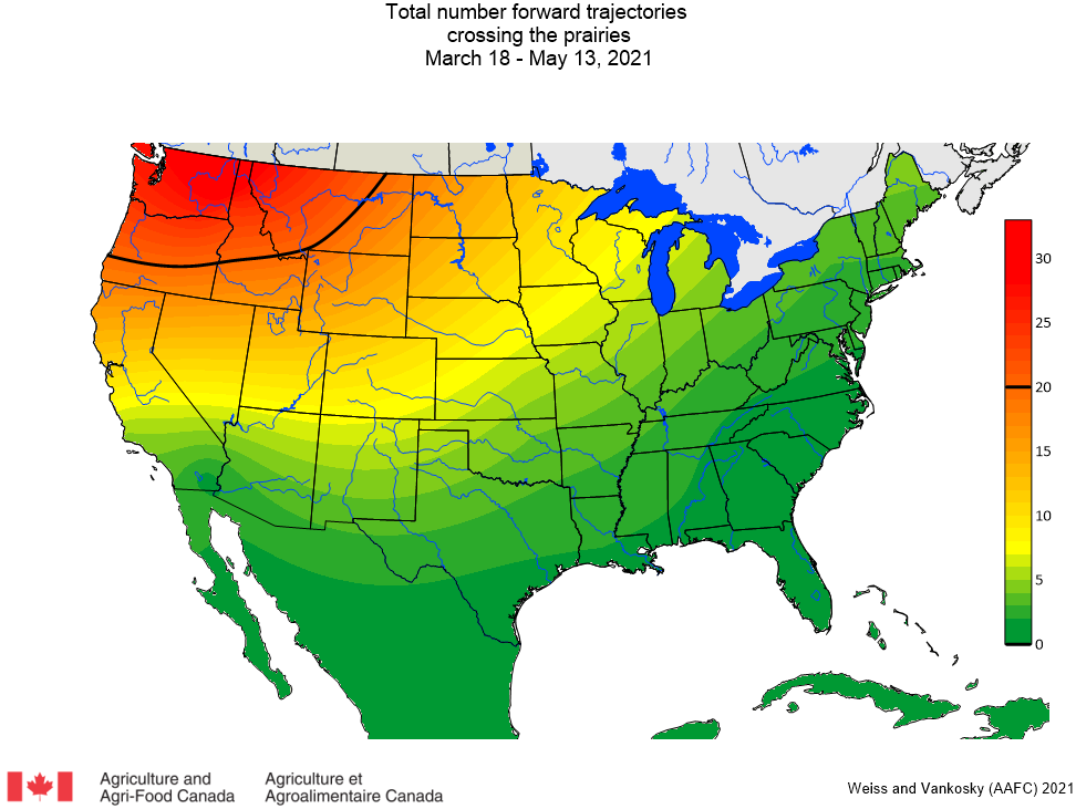
2. FORWARD TRAJECTORIES (FT) The following map presents the total number of dates (since April 1, 2022) with forward trajectories (originating from Mexico and USA) that were predicted to cross the Canadian prairies (Fig. 6). This week (June 21-27, 2022) there was a decrease in the number of (n=19) forward trajectories predicted to cross the prairies (last week n=50). Results indicate that the greatest number of forward trajectories entering the prairies have originated from the Pacific Northwest (Idaho, Oregon, Washington), Montana and Wyoming.
Figure 6. Total number of dates with forward trajectories, originating from various regions of the United States and Mexico, crossing the prairies between April 1 and June 27, 2022.
View historical PPMN wind trajectory reports by following this link which sorts the reports from most recent to oldest.
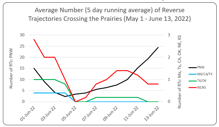
1. REVERSE TRAJECTORIES (RT) Since May 1, 2022, the majority of reverse trajectories that have crossed the prairies have originated from the Pacific Northwest (Idaho, Oregon and Washington). The number of incoming trajectories during the first two weeks of June was much lower than this past week (June 14-20, 2022) (Fig. 1). The number of reverse trajectories, originating from Mexico, California, Texas, Oklahoma, Nebraska and Kansas have significantly increased since June 18th.
Figure 1. Average number (based on a 5-day running average) of reverse trajectories (RT) crossing the prairies for the period of June 1-20, 2022.
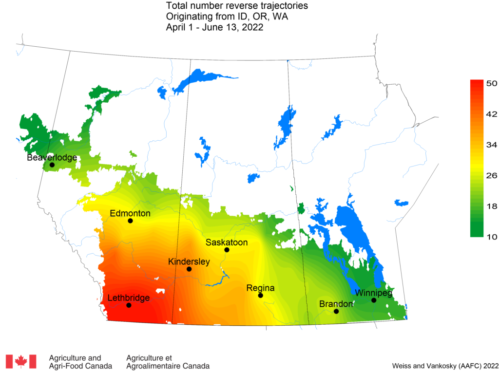
a. Pacific Northwest (Idaho, Oregon, Washington) – The majority of Pacific Northwest reverse trajectories have been reported to pass over southern and central Alberta and western Saskatchewan (Fig. 2). This past week (June 14-20, 2022) the ECCC model predicted that 124 reverse trajectories would cross the prairies. This is similar to the number of reverse trajectories expected in the previous week (n=134).
Figure 2. Total number of dates with reverse trajectories originating over the Idaho, Oregon, and Washington that have crossed the prairies between April 1 and June 20, 2022.
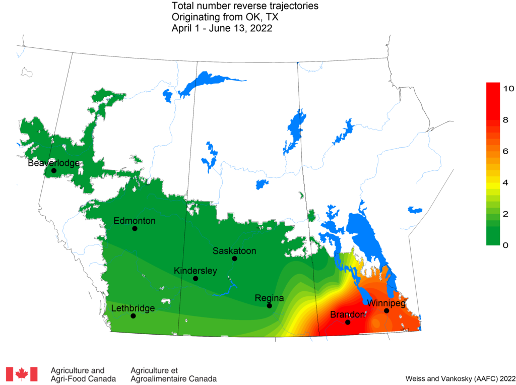
b. Mexico and southwest USA (Texas, California) – Prior to this past week, the most recent reverse trajectories that originated from Mexico, California or Texas crossed over the Canadian prairies on May 31st. This week a total of 44 reverse trajectories were predicted to cross the prairies. Most reverse trajectories have entered Manitoba during the 2022 growing season. This week trajectories crossed Medicine Hat, Kindersley, and Swift Current.
Figure 3. The total number of dates with reverse trajectories originating over Mexico, California and Texas that have crossed the prairies between April 1 and June 20, 2022.
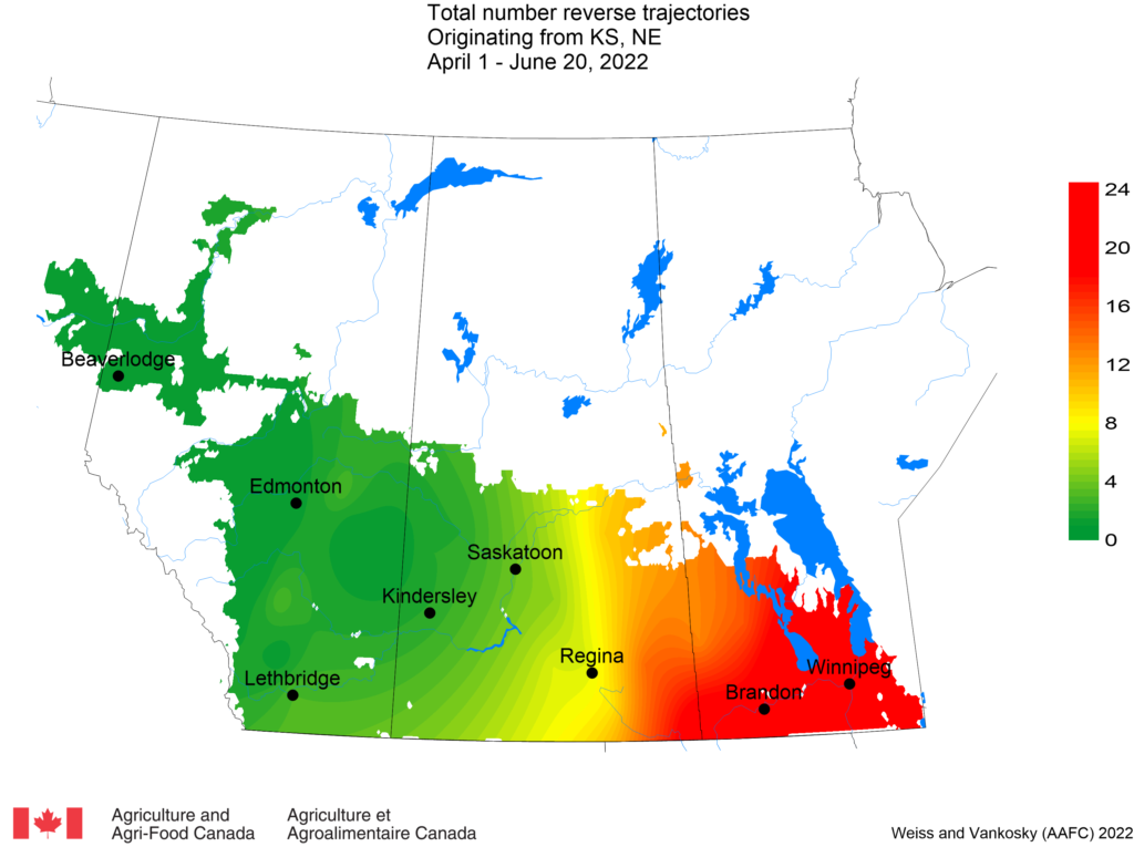
c. Oklahoma and Texas – Since April 1, reverse trajectories were reported for Manitoba and eastern Saskatchewan. This week, a number of these reverse trajectories passed over central Saskatchewan, including Saskatoon, Moose Jaw and Regina (Fig. 4). This week there were significantly more (n=44) reverse trajectories than last week (n=1) that originated from Texas and Oklahoma.
Figure 4. The total number of dates with reverse trajectories originating over Texas and Oklahoma that have crossed the prairies between May 1 and June 20, 2022.
d. Nebraska and Kansas – Similar to last week, a number of reverse trajectories originating from Kansas and Nebraska have crossed central and western prairie locations (Fig. 5). This past week (June 14-20, 2022) the ECCC model predicted that 51 reverse trajectories passed over the prairies. This is a significant increase from the previous week (n=8).
Figure 5. The total number of dates with reverse trajectories originating over Kansas and Nebraska that have crossed the prairies between April 1 and June 20, 2022.
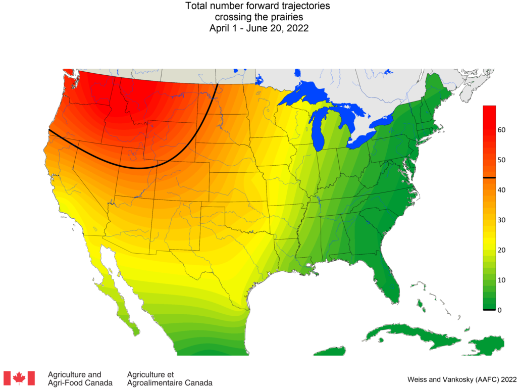
2. FORWARD TRAJECTORIES (FT) The following map presents the total number of dates (since April 1, 2022) with forward trajectories (originating from Mexico and USA) that were predicted to cross the Canadian prairies (Fig. 6). This week (June 14-20, 2022) there was an increase in the number (n=50) of forward trajectories predicted to cross the prairies (n=34 last week). Results indicate that the greatest number of forward trajectories entering the prairies have originated from the Pacific Northwest (Idaho, Oregon, Washington), Montana and Wyoming.
Figure 6. Total number of dates with forward trajectories, originating from various regions of the United States and Mexico, crossing the prairies between April 1 and June 20, 2022.
View historical PPMN wind trajectory reports by following this link which sorts the reports from most recent to oldest.
1. REVERSE TRAJECTORIES (RT) Since May 1, 2022, the majority of reverse trajectories that have crossed the prairies originated from the Pacific Northwest (Idaho, Oregon and Washington) (Fig. 1). This past week (June 7-13, 2022) the number of reverse trajectories originating from Mexico, California, Texas, Oklahoma, Nebraska and Kansas continued to be low. This week reverse trajectories generally originated over the Pacific Ocean before entering the prairies.
Figure 1. Average number (based on a 5-day running average) of reverse trajectories (RT) crossing the prairies for the period of June 1-13, 2022.
a. Pacific Northwest (Idaho, Oregon, Washington) – The majority of Pacific Northwest reverse trajectories have been reported to pass over southern and central Alberta and western Saskatchewan (Fig. 2). This past week (June 7-13, 2022) the ECCC model predicted that 134 reverse trajectories would cross the prairies. This is a significant increase over the previous week (n=26).
Figure 2. Total number of dates with reverse trajectories originating over the Idaho, Oregon, and Washington that have crossed the prairies between April 1 and June 13, 2022.
b. Mexico and southwest USA (Texas, California) – This past week (June 7-13, 2022) the model reported that zero reverse trajectories that originated from Mexico, California or Texas crossed over the Canadian prairies. Since May 1, 2022, these trajectories have been restricted to Manitoba and eastern Saskatchewan (Fig. 3).
Figure 3. The total number of dates with reverse trajectories originating over Mexico, California and Texas that have crossed the prairies between April 1 and June 13, 2022.
c. Oklahoma and Texas – Since April 1, reverse trajectories were reported for Manitoba and eastern Saskatchewan. This past week (June 7-13, 2022) one trajectory crossed over Edmonton, Alberta.
Figure 4. The total number of dates with reverse trajectories originating over Texas and Oklahoma that have crossed the prairies between May 1 and June 13, 2022.
d. Nebraska and Kansas – Until this week, reverse trajectories originating from Kansas and Nebraska have been associated with southeastern Saskatchewan and southern Manitoba (Fig. 5). This past week (June 7-13, 2022) the ECCC model predicted that 8 reverse trajectories passed over the prairies. Six of these reverse trajectories passed over parts of Alberta, including Beiseker, Olds, Edmonton, Rycroft, and Fort Vermilion and Fort St. John in British Columbia.
Figure 5. The total number of dates with reverse trajectories originating over Kansas and Nebraska that have crossed the prairies between April 1 and June 13, 2022.
2. FORWARD TRAJECTORIES (FT) The following map presents the total number of dates (since April 1, 2022) with forward trajectories (originating from Mexico and USA) that were predicted to cross the Canadian prairies (Fig. 6). This week (May 31 to June 6, 2022) there The following map presents the total number of dates (since April 1, 2022) with forward trajectories (originating from Mexico and USA) that were predicted to cross the Canadian prairies (Fig. 6). This week (June 7-13, 2022) there was an increase in the number of forward trajectories (n=34) predicted to cross the prairies compared to last week (n=12). Results indicate that the greatest number of forward trajectories entering the prairies have originated from the Pacific Northwest (Idaho, Oregon, Washington), Montana and Wyoming.
Figure 6. Total number of dates with forward trajectories, originating from various regions of the United States and Mexico, crossing the prairies between April 1 and June 13, 2022.
View historical PPMN wind trajectory reports by following this link which sorts the reports from most recent to oldest.
1. REVERSE TRAJECTORIES (RT) Since May 1, 2022 the majority of reverse trajectories that have crossed the prairies originated from the Pacific Northwest (Idaho, Oregon and Washington) (Fig. 1). Relative to previous weeks, there was a significant decrease in the number of trajectories that were predicted to cross over the prairies from May 31 – June 6, 2022. This week reverse trajectories generally originated over the arctic before entering the prairies.
Figure 1. Average number (based on a 5-day running average) of reverse trajectories (RT) crossing the prairies for the period of May 1-June 6, 2022.
a. Pacific Northwest (Idaho, Oregon, Washington) – The majority of Pacific Northwest reverse trajectories have been reported to pass over southern and central Alberta and western Saskatchewan (Fig. 2). This past week (May 31-June 6, 2022) the ECCC model predicted that 26 reverse trajectories passed over the prairies. This is a significant decrease compared to the previous week (n=124).
Figure 2. Total number of dates with reverse trajectories originating over the Idaho, Oregon, and Washington that have crossed the prairies between April 1 and June 6, 2022.
b. Mexico and southwest USA (Texas, California) – This past week (May 31 to June 6, 2022) reverse trajectories that originated from Mexico, California or Texas crossed over Carman and Selkirk (May 31, 2022). Since April 1, reverse trajectories were reported for Manitoba (Portage, Selkirk, Brandon, Carman, Russell) and eastern Saskatchewan (Gainsborough, Grenfell) (Fig. 3).
Figure 3. The total number of dates with reverse trajectories originating over Mexico, California and Texas that have crossed the prairies between April 1 and June 6, 2022.
c. Oklahoma and Texas – Since April 1, reverse trajectories were reported for Manitoba and eastern Saskatchewan (Fig. 4). This past week (May 31 to June 6, 2022) there has been an increase in the number of reverse trajectories that have crossed over southeastern Saskatchewan (Weyburn and Gainsborough) and Manitoba (Portage and Brandon).
Figure 4. The total number of dates with reverse trajectories originating over Texas and Oklahoma that have crossed the prairies between May 1 and June 6, 2022.
d. Nebraska and Kansas – Reverse trajectories, originating from Kansas and Nebraska, have crossed southeastern Saskatchewan and southern Manitoba (Fig. 5). This past week (May 31 to June 6, 2022) the ECCC model predicted that 6 reverse trajectories passed over the prairies. This is a significant decrease compared to the previous week (n=27).
Figure 5. The total number of dates with reverse trajectories originating over Kansas and Nebraska that have crossed the prairies between April 1 and June 6, 2022.
2. FORWARD TRAJECTORIES (FT) The following map presents the total number of dates (since April 1, 2022) with forward trajectories (originating from Mexico and USA) that were predicted to cross the Canadian prairies (Fig. 6). This week (May 31 to June 6, 2022) there were fewer (n=12) forward trajectories predicted to cross the prairies than the previous week (n=45). Results indicate that the greatest number of forward trajectories entering the prairies have originated from the Pacific Northwest (Idaho, Oregon, Washington), Montana and Wyoming.
Figure 6. Total number of dates with forward trajectories, originating from various regions of the United States and Mexico, crossing the prairies between April 1 and June 6, 2022.
View historical PPMN wind trajectory reports by following this link which sorts the reports from most recent to oldest.
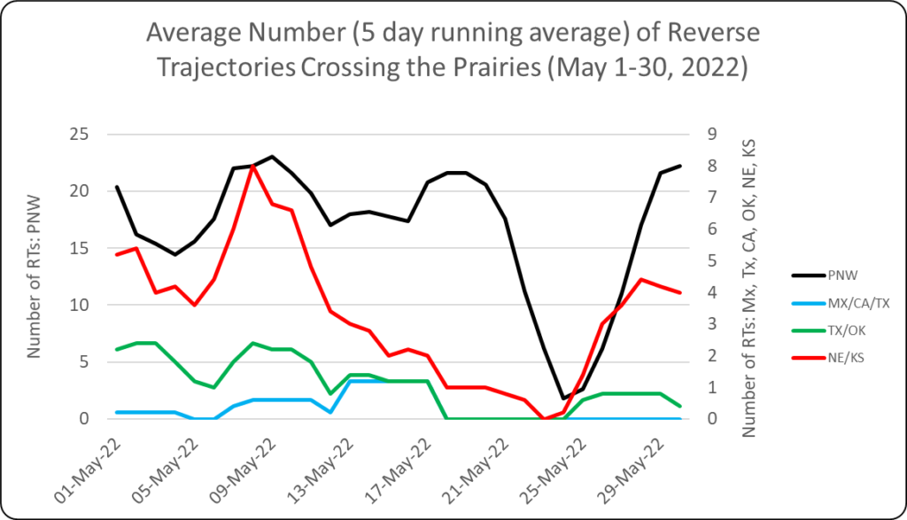
1. REVERSE TRAJECTORIES (RT) Since May 1, 2022, the majority of reverse trajectories crossing the prairies originated from the Pacific Northwest (Idaho, Oregon and Washington) (Fig. 1). Relative to previous weeks, this past week (May 24-30, 2022) there was a significant increase in the number of trajectories (PNW, OK/TX and NE/KS) that passed over the prairies.
Figure 1. Average number (based on a 5-day running average) of reverse trajectories (RT) crossing the prairies for the period of May 1-30, 2022.
a. Pacific Northwest (Idaho, Oregon, Washington) – The majority of Pacific Northwest reverse trajectories have been reported to pass over southern and central Alberta and western Saskatchewan (Fig. 2).
Figure 2. Total number of dates with reverse trajectories originating over the Idaho, Oregon, and Washington that have crossed the prairies between April 1 and May 30, 2022.
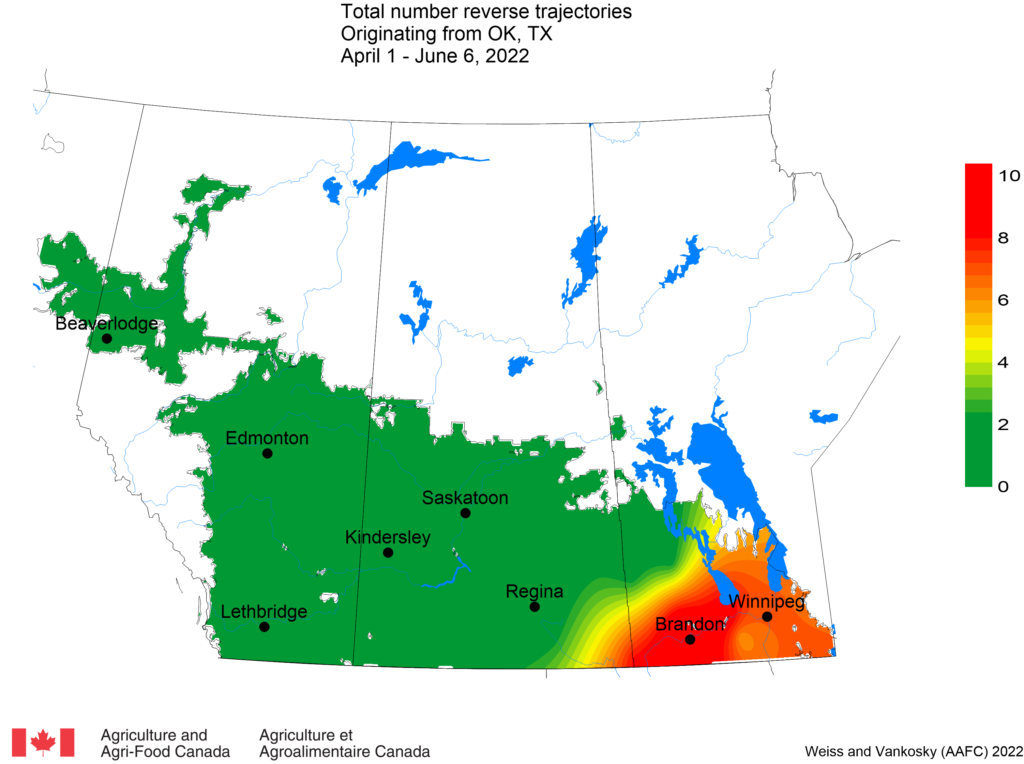
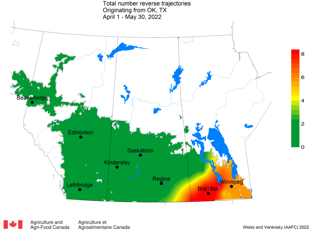
b. Mexico and southwest USA (Texas, California) – This past week there have not been any reverse trajectories that originated from Mexico, California or Texas. Since April 1, reverse trajectories were reported for Manitoba (Portage, Selkirk, Brandon, Carman, Russell) and eastern Saskatchewan (Gainsborough, Grenfell) (Fig. 3).
Figure 3. The total number of dates with reverse trajectories originating over Mexico, California and Texas that have crossed the prairies between April 1 and May 30, 2022.
c. Oklahoma and Texas – Since April 1, reverse trajectories were reported for Manitoba and eastern Saskatchewan (Fig. 4). This past week (May 24-30, 2022) there was an increase in the number of reverse trajectories that have crossed over southeastern Saskatchewan (Weyburn and Gainsborough) and Manitoba (Portage and Brandon) relative to previous weeks.
Figure 4. The total number of dates with reverse trajectories originating over Texas and Oklahoma that have crossed the prairies between May 1 and May 30, 2022.
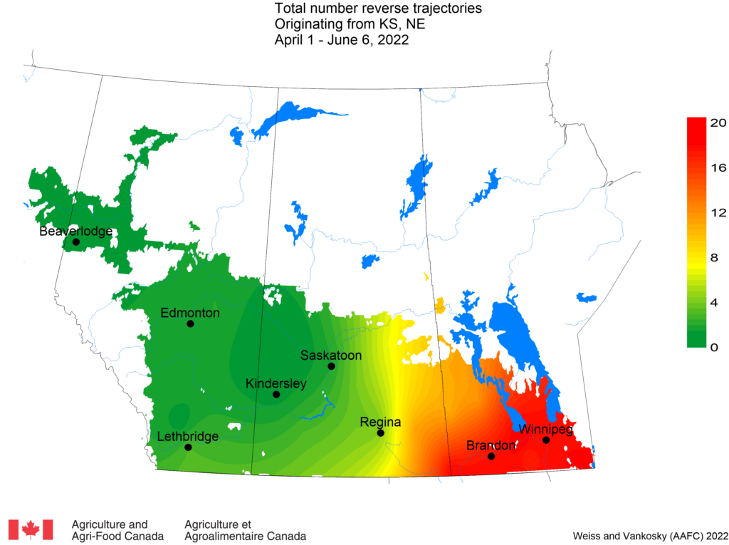
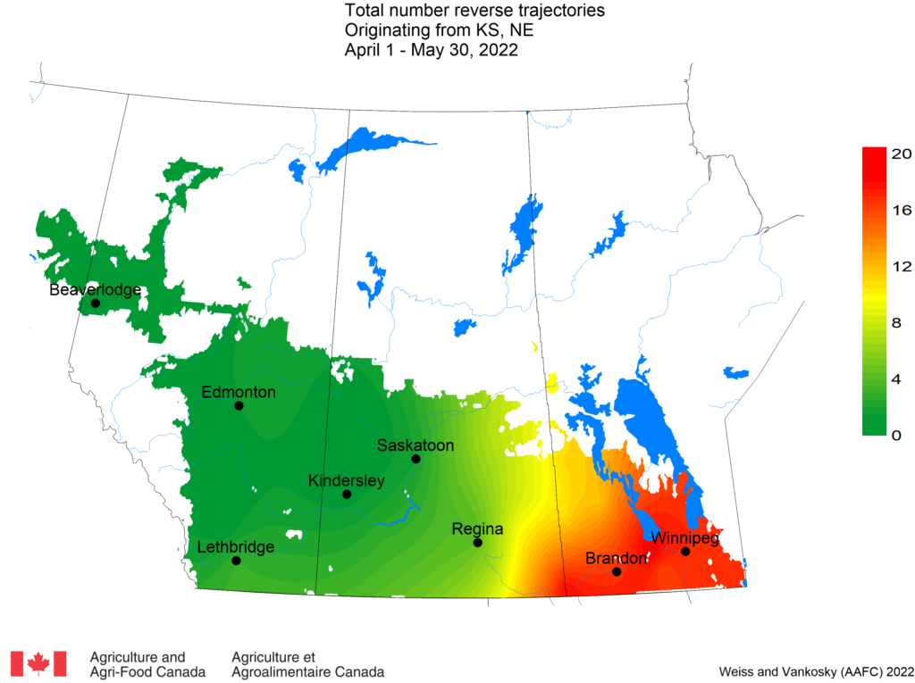
d. Nebraska and Kansas – Reverse trajectories, originating from Kansas and Nebraska have crossed southeastern Saskatchewan and southern Manitoba (April 1 – May 23, 2022) (Fig. 5). This past week (May 24-30, 2022) there was an increase in the number of reverse trajectories that have crossed over eastern Saskatchewan and Manitoba relative to previous weeks.
Figure 5. The total number of dates with reverse trajectories originating over Kansas and Nebraska that have crossed the prairies between April 1 and May 30, 2022.
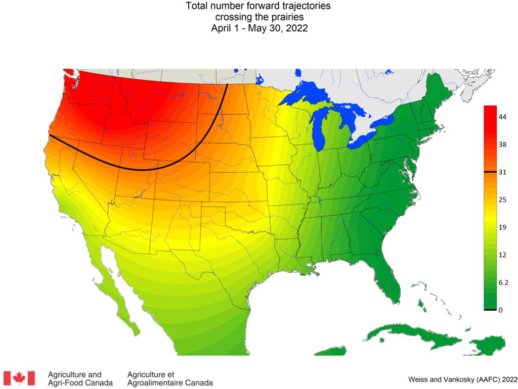
2. FORWARD TRAJECTORIES (FT) The following map presents the total number of dates (since April 1, 2022) with forward trajectories (originating from Mexico and USA) that were predicted to cross the Canadian prairies (Fig. 6). Results indicate that the greatest number of forward trajectories entering the prairies have originated from the Pacific Northwest (Idaho, Oregon, Washington), Montana and Wyoming.
Figure 6. Total number of dates with forward trajectories, originating from various regions of the United States and Mexico, crossing the prairies between April 1 and May 30, 2022.
View historical PPMN wind trajectory reports by following this link which sorts the reports from most recent to oldest.
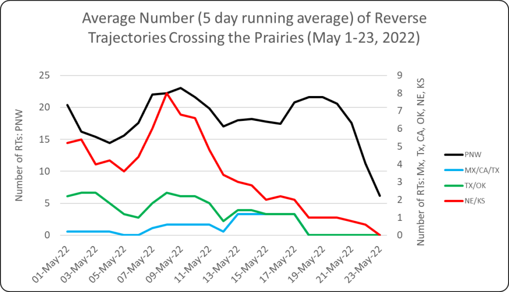
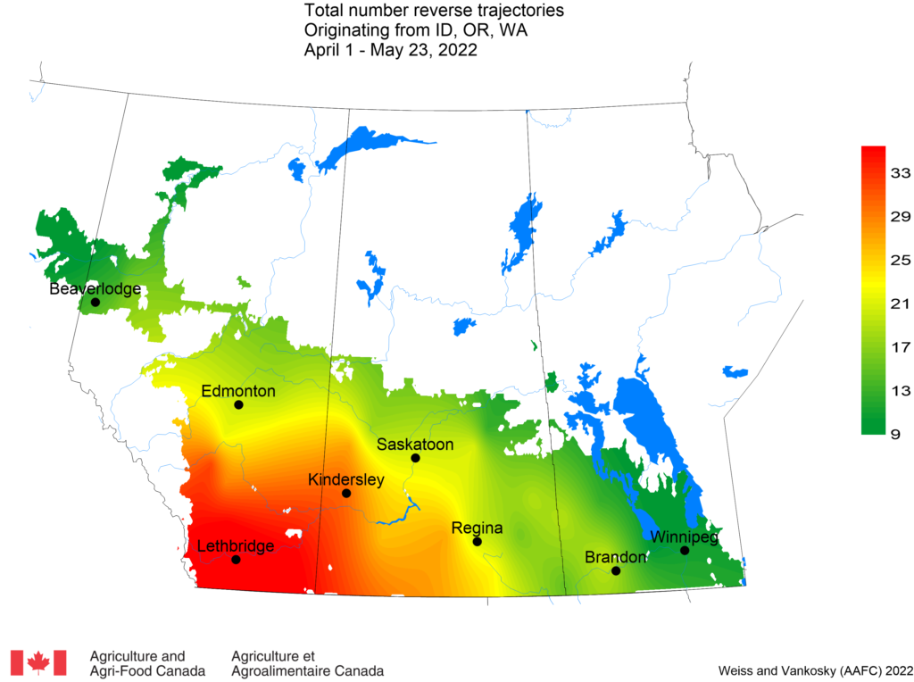
1. REVERSE TRAJECTORIES (RT) Since May 1, 2022, the majority of reverse trajectories that have crossed the prairies originated from the Pacific Northwest (Idaho, Oregon and Washington) (Fig. 1). Relative to previous weeks, this past week (May 17-23, 2022) there were fewer trajectories passing over the prairies.
Figure 1. Average number (based on a 5-day running average) of reverse trajectories (RT) crossing the prairies for the period of May 1-23, 2022.
a. Pacific Northwest (Idaho, Oregon, Washington) – The majority of Pacific Northwest reverse trajectories have been reported to pass over southern and central Alberta and western Saskatchewan (Fig. 2).
Figure 2. Total number of dates with reverse trajectories originating over the Idaho, Oregon, and Washington that have crossed the prairies between April 1 and May 23, 2022.
b. Mexico and southwest USA (Texas, California) – This past week there were no reverse trajectories originating from Mexico, California or Texas. Since April 1, reverse trajectories were reported for Manitoba (Portage, Selkirk, Brandon, Carman, Russell) and eastern Saskatchewan (Gainsborough, Grenfell) (Fig. 3).
Figure 3. The total number of dates with reverse trajectories originating over Mexico, California and Texas that have crossed the prairies between April 1 and May 23, 2022.
c. Oklahoma and Texas – Since April 1, reverse trajectories were reported for Manitoba and eastern Saskatchewan (Fig. 4). No trajectories were predicted for May 17-23, 2022.
Figure 4. The total number of dates with reverse trajectories originating over Texas and Oklahoma that have crossed the prairies between May 1 and May 23, 2022.
d. Nebraska and Kansas – Reverse trajectories, originating from Kansas and Nebraska have crossed southeastern Saskatchewan and southern Manitoba (April 1 – May 23, 2022) (Fig. 5).
Figure 5. The total number of dates with reverse trajectories originating over Kansas and Nebraska that have crossed the prairies between April 1 and May 23, 2022.
2. FORWARD TRAJECTORIES (FT) The following map presents the total number of dates (since April 1, 2022) with forward trajectories (originating from Mexico and USA) predicted to cross the Canadian prairies (Fig. 6). Results indicate that the greatest number of forward trajectories entering the prairies have originated from the Pacific Northwest (Idaho, Oregon, Washington), Montana and Wyoming.
Figure 6. Total number of dates with forward trajectories, originating from various regions of the United States and Mexico, crossing the prairies between April 1 and May 23, 2022.
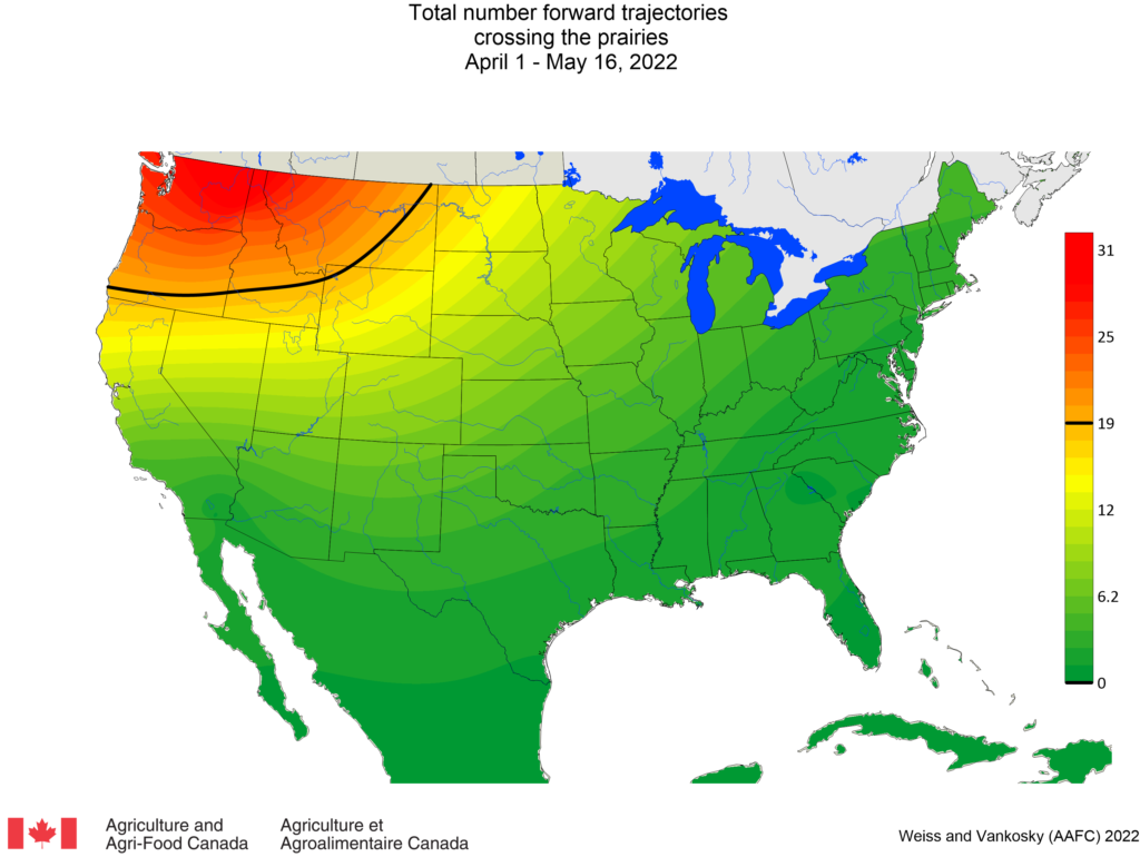
1. REVERSE TRAJECTORIES (RT) Since May 1, 2022, the majority of reverse trajectories crossing the prairies originated from the Pacific Northwest (Idaho, Oregon and Washington) (Fig. 1).
Figure 1. Average number (based on a 5-day running average) of reverse trajectories (RT) crossing the prairies for the period of May 1-16, 2022.
a. Pacific Northwest (Idaho, Oregon, Washington) – The majority of Pacific Northwest reverse trajectories have passed over south-central Alberta and western Saskatchewan (link to view Fig. 2).
b. Mexico and southwest USA (Texas, California) – Since April 1, reverse trajectories were reported for Manitoba (Portage, Selkirk, Brandon, Carman, Russell) and eastern Saskatchewan (Gainsborough, Grenfell) (link to view Fig. 3).
c. Oklahoma and Texas – Since April 1, reverse trajectories were reported for Manitoba and eastern Saskatchewan (link to view Fig. 4).
2. FORWARD TRAJECTORIES (FT) The following map presents the total number of dates (since April 1, 2022) with forward trajectories (originating from Mexico and USA) predicted to cross the Canadian prairies (Fig. 5). Results indicate that the greatest number of forward trajectories entering Canada originated from the Pacific Northwest (Idaho, Oregon, Washington).
Figure 5. Total number of dates with forward trajectories, originating from various regions of the United States and Mexico, crossing the prairies between April 1 and May 16, 2022.
Access background information for how and why wind trajectories are monitored in this post.
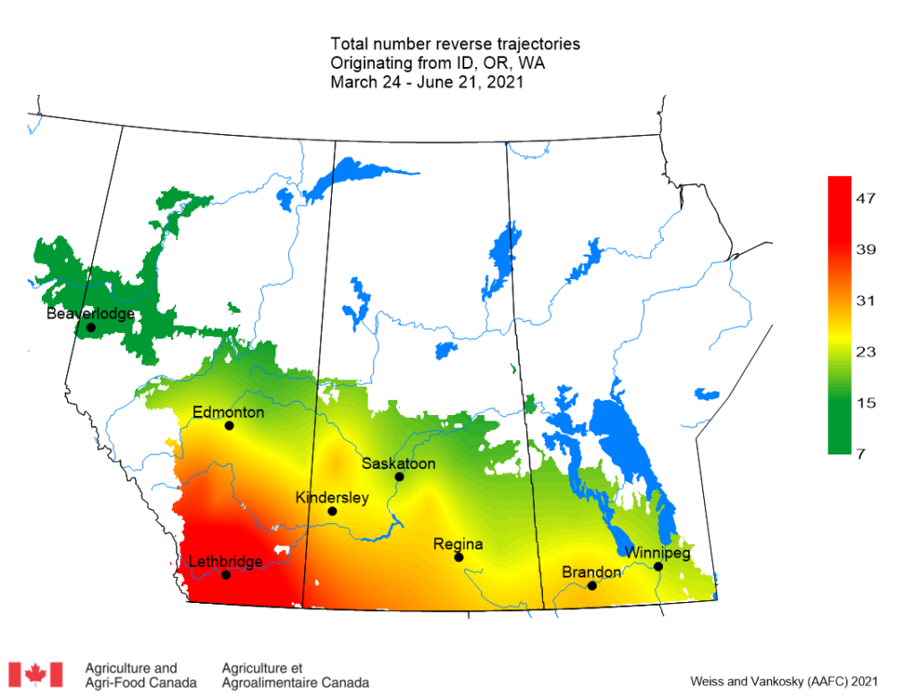
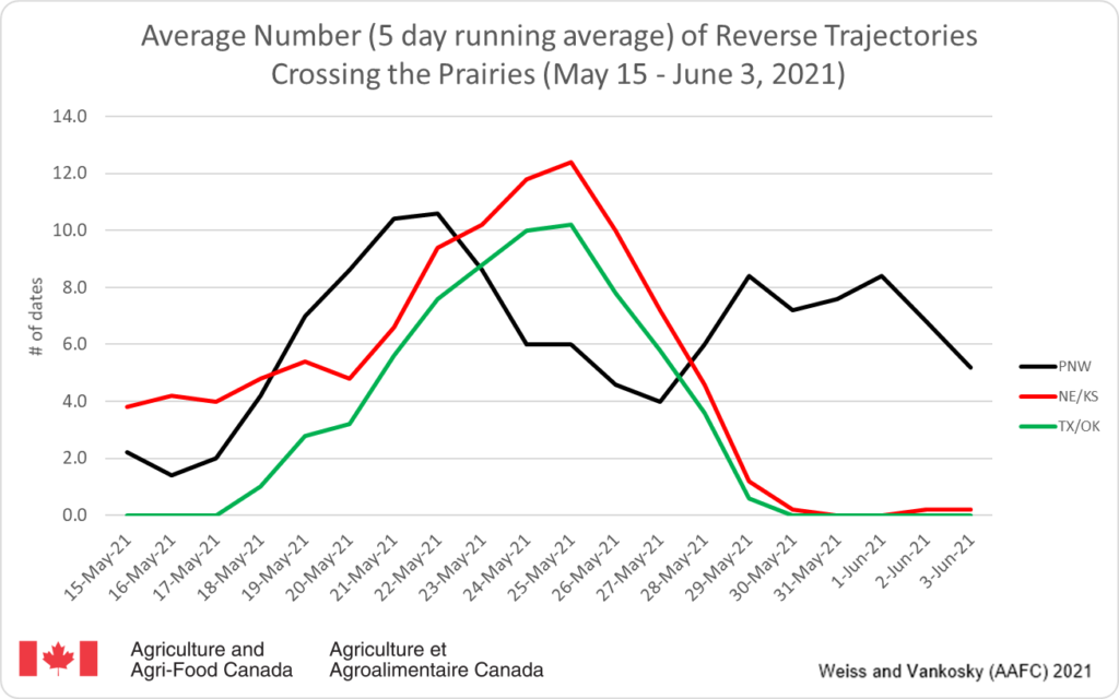
1. REVERSE TRAJECTORIES (RT) Since June 16, 2021, there have been a decreasing number of reverse trajectories that moved north from the Pacific Northwest (Idaho, Oregon and Washington), Texas, Oklahoma, Kansas and Nebraska (Fig. 1).
Figure 1. The average number (based on a 5-day running average) of reverse trajectories that have crossed the prairies for the period of May 21 – June 21, 2021.
a. Pacific Northwest (Idaho, Oregon, Washington) – This week (June 16-21, 2021) there have been 43 trajectories that have crossed Alberta, Manitoba and Saskatchewan that originated in the Pacific Northwest (Fig. 2).
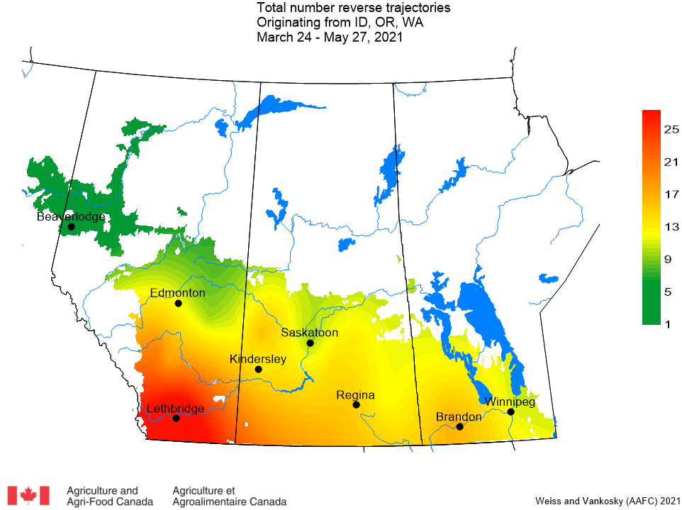
Figure 2. Total number of dates with reverse trajectories originating over the Pacific Northwest (Idaho, Oregon, and Washington) and have crossed the prairies between March 24 and June 21, 2021.
b. Mexico and southwest USA (Texas, California) – This week (June 16 – 21, 2021) there have been 3 trajectories that originated in Mexico or the southwest USA that have crossed the prairies.
c. Oklahoma and Texas – This week (June 16 – 21, 2021) there have been 4 trajectories originating in Oklahoma or Texas that have passed over the prairies.
d. Kansas and Nebraska – This week (June 16 – 21, 2021) there have been 8 trajectories that originated in Kansas or Nebraska that passed over the prairies.
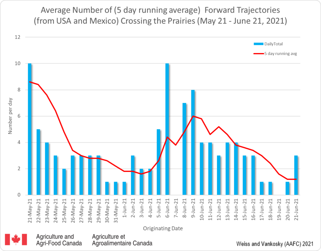
2. FORWARD TRAJECTORIES (FT) a. Since June 9, 2021, there has been a steady decrease in the number of forward trajectories that are predicted to cross the prairies (Fig. 3). The dates on the graph report when the trajectories originated in the USA (blue bars). These trajectories generally require 3-5 days to enter the prairies (red line).
Figure 3. The average number (based on a 5 day running average) of forward trajectories that were predicted to cross the prairies for the period of May 21-June 21, 2021.
Access background information for how and why wind trajectories are monitored in this post.
1. REVERSE TRAJECTORIES (RT) Similar to last week, this week there were an increasing number of reverse trajectories moving north from the Pacific Northwest (Idaho, Oregon and Washington) (Fig. 1). Though this US region can be a source of diamondback moths (DBM), the ECCC models predict air movement, not actual occurrence of diamondback moths. Fields (and DBM traps) should be monitored for DBM adults and larvae.
Figure 1. The average number (based on a 5 day running average) of reverse trajectories that have crossed the prairies for the period of May 15 – June 15, 2021.
a. Pacific Northwest (Idaho, Oregon, Washington) – This week (June 11-15, 2021) there were 109 trajectories (versus 106 last week) that crossed Alberta, Manitoba and Saskatchewan (Fig. 2).
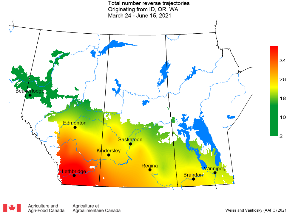
Figure 2. Total number of dates with reverse trajectories originating over the Pacific Northwest (Idaho, Oregon, and Washington) and have crossed the prairies between March 24 and June 15, 2021.
b. Mexico and southwest USA (Texas, California) – Compared to previous years, there has been a noticeable increase in number of trajectories from the southern US. The majority of these trajectories have crossed Manitoba and eastern Saskatchewan (Fig. 3). This week (June 11-15, 2021) there have been 11 trajectories (10 last week) that originated in Mexico or the southwest USA that have crossed the prairies.
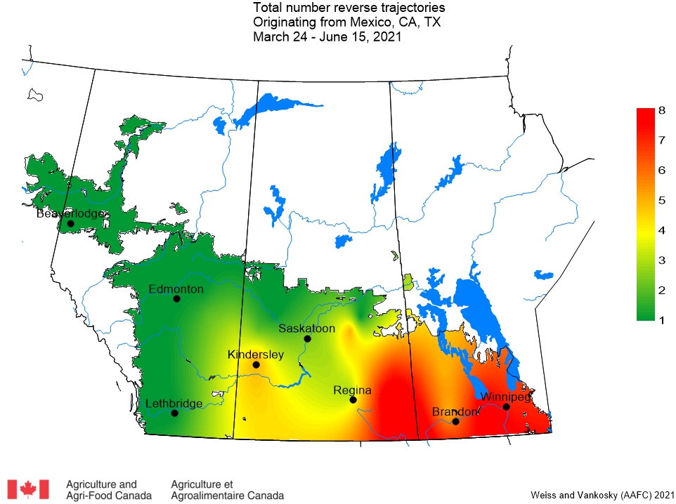
Figure 3. The total number of dates with reverse trajectories originating over Mexico, California and Texas and have crossed the prairies between March 24 and June 15, 2021.
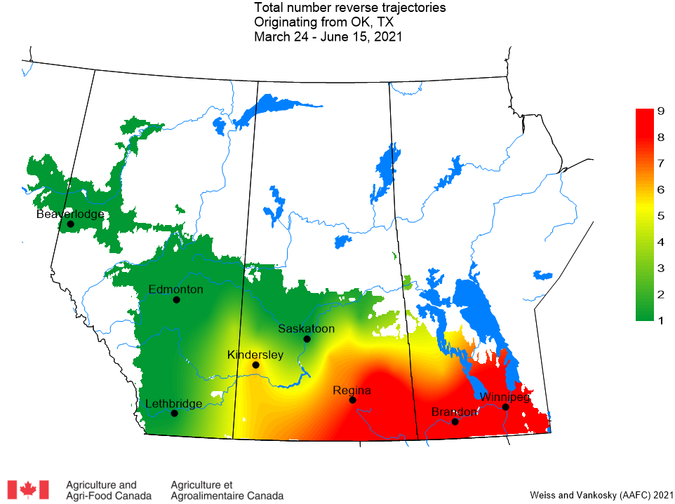
c. Oklahoma and Texas – The majority of these trajectories passed over Manitoba and eastern Saskatchewan (Fig. 4). This week (June 11-15, 2021) there were 18 trajectories (13 last week) originating in Oklahoma or Texas that passed over the prairies.
Figure 4. The total number of dates with reverse trajectories originating over Oklahoma and Texas and have crossed the prairies between March 24 and June 15, 2021.
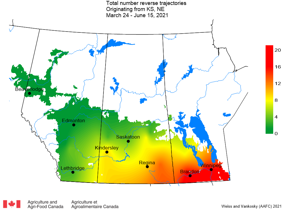
d. Kansas and Nebraska – This week (June 11-15, 2021) there were 20 trajectories (19 last week) that originated in Kansas or Nebraska that passed over the prairies (Fig. 5).
Figure 5. The total number of dates with reverse trajectories originating over Kansas and Nebraska and have crossed the prairies between March 24 and June 15, 2021.
2. FORWARD TRAJECTORIES (FT) a. This week there was a decrease in the number of forward trajectories predicted to cross the prairies (Fig. 6). The dates on the graph report when the trajectories originated in the USA (blue bars). These trajectories generally require 3-5 days to enter the prairies (red line). The data suggests that there will be increased potential for introduction of DBM to the prairies.
Figure 6. The average number (based on a 5 day running average) of forward trajectories that were predicted to cross the prairies for the period of May 15-June 15, 2021.
Access background information for how and why wind trajectories are monitored in this post.
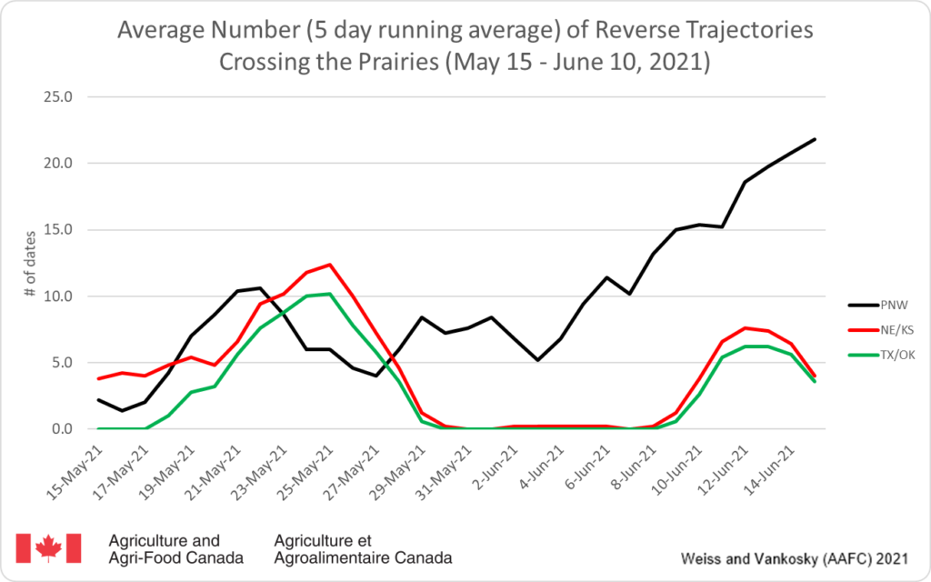
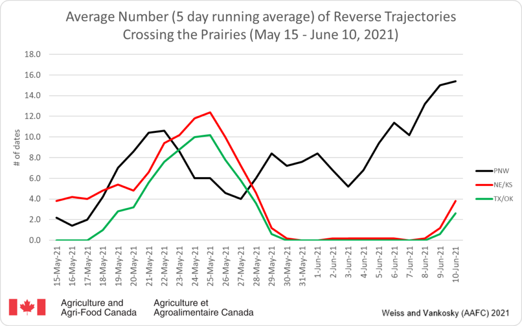
1. REVERSE TRAJECTORIES (RT) This past week (in particular June 9 and 10) there were an increasing number of reverse trajectories moving north from the Pacific Northwest (Idaho, Oregon and Washington), Texas, Oklahoma, Kansas and Nebraska (Fig. 1). Though these US regions can be a source of diamondback moths (DBM), the ECCC models predict air movement, not actual occurrence of diamondback moths. Fields (and DBM traps) should be monitored for DBM adults and larvae.
Figure 1. The average number (based on a 5 day running average) of reverse trajectories that have crossed the prairies for the period of May 15 – June 10 2021.
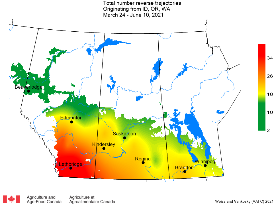
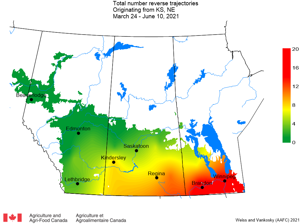
a. Pacific Northwest (Idaho, Oregon, Washington) – This week there have been 106 trajectories (53 last week) that have crossed Alberta, Manitoba and Saskatchewan. This growing season, PNW trajectories have crossed all parts of the prairies (Fig. 2).
Figure 2. Total number of dates with reverse trajectories originating over the Pacific Northwest (Idaho, Oregon, and Washington) and have crossed the prairies between March 24 and June 10, 2021.
b. Mexico and southwest USA (Texas, California) – Compared to previous years, there has been a noticeable increase in the number of trajectories from the southern US. The majority of these trajectories have crossed Manitoba and eastern Saskatchewan (Fig. 3). This week there have been 10 trajectories (0 last week) that originated in Mexico or the southwest USA that have crossed the prairies (Fig. 3).
Figure 3. The total number of dates with reverse trajectories originating over Mexico, California and Texas and have crossed the prairies between March 24 and June 10, 2021.
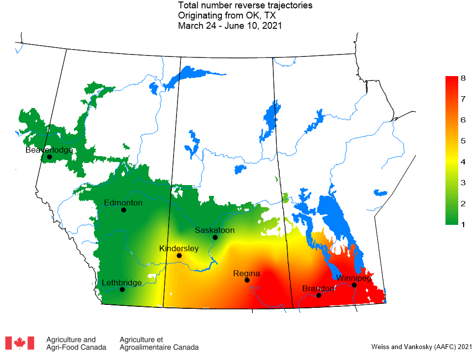
c. Oklahoma and Texas – This week there have been 13 trajectories (0 last week) originating in Oklahoma or Texas that have passed over the prairies (Fig. 4).
Figure 4. The total number of dates with reverse trajectories originating over Oklahoma and Texas and have crossed the prairies between March 24 and June 10, 2021.
d. Kansas and Nebraska – This week there were 19 trajectories (versus 1 last week) that originated in Kansas or Nebraska that passed over the prairies (Fig. 5). Relative to the reverse trajectories associated with Oklahoma and Texas (Fig. 4), the trajectories from Kansas and Nebraska have crossed further into Alberta (Fig. 5).
Figure 5. The total number of dates with reverse trajectories originating over Kansas and Nebraska and have crossed the prairies between March 24 and June 10, 2021.
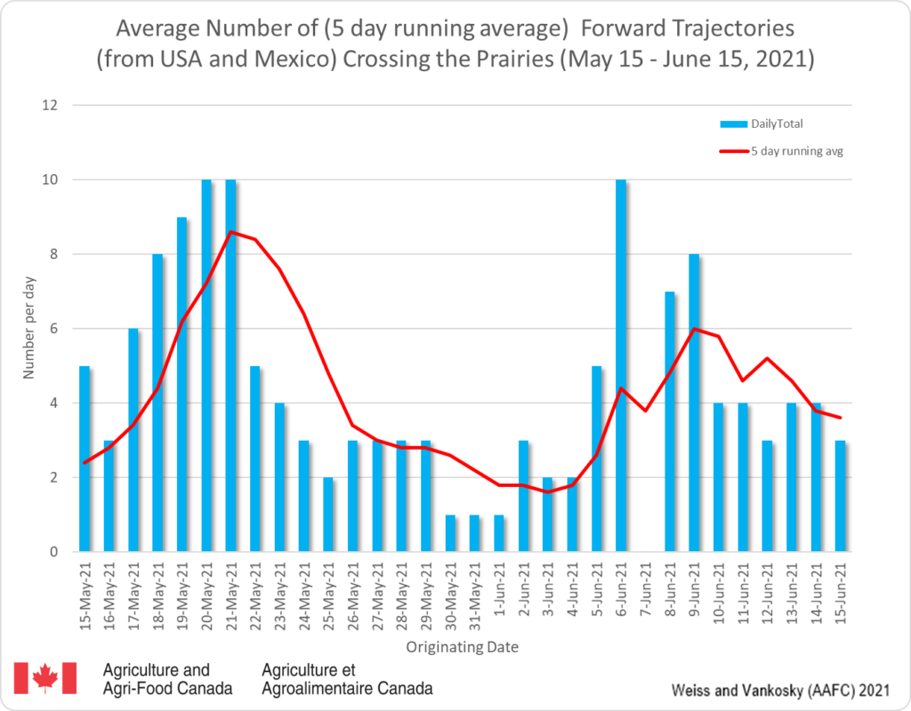
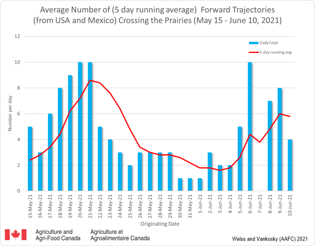
2. FORWARD TRAJECTORIES (FT) a. Continuing a trend that began last week, this week there was an increase in the number of forward trajectories predicted to cross the prairies (Fig. 6). The dates on the graph report when the trajectories originated in the USA (blue bars). These trajectories generally require 3-5 days to enter the prairies (red line). The data suggests that there will be increased potential for introduction of DBM to the prairies.
Figure 6. The average number (based on a 5-day running average) of forward trajectories that were predicted to cross the prairies for the period of May 15-June 10, 2021.
Access background information for how and why wind trajectories are monitored in this post.
1. REVERSE TRAJECTORIES (RT) This past week there were an increasing number of reverse trajectories moving north from the Pacific Northwest (Idaho, Oregon and Washington) (Fig. 1). Though this US region can be a source of diamondback moths, the ECCC models predict air movement, not actual occurrence of diamondback moths.
Figure 1. The average number (based on a 5 day running average) of reverse trajectories that have crossed the prairies for the period of May 15 – June 3 2021.
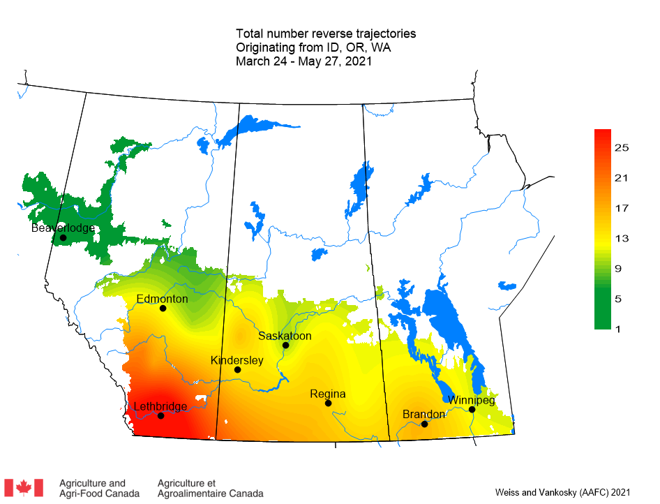
a. Pacific Northwest (Idaho, Oregon, Washington) – This week there were 53 trajectories (compared to 36 last week) that crossed Alberta, Manitoba and Saskatchewan. In previous years, the majority of Pacific Northwest reverse trajectories usually have been reported to pass over southern Alberta. However, tis growing season, PNW trajectories have crossed all parts of the prairies (Figs. 2 and 3).
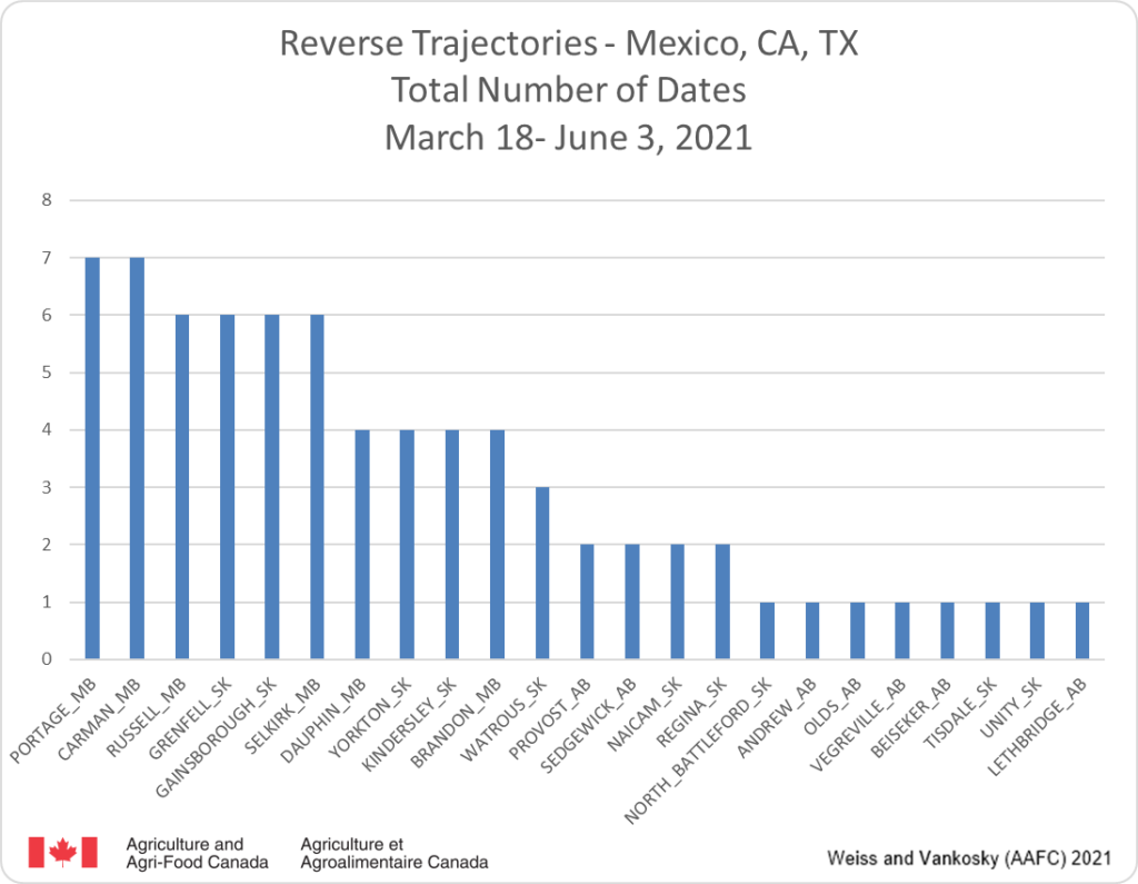
Figure 2. Total number of reverse trajectories originating across Idaho, Oregon, and Washington and have crossed specific prairie locations between March 18 and June 3, 2021.Figure 3. Total number of dates with reverse trajectories originating over the Pacific Northwest (Idaho, Oregon, and Washington) and have crossed the prairies between March 24 and June 3, 2021.
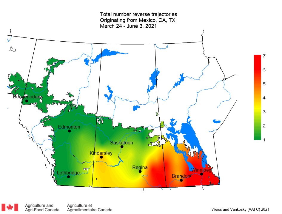
b. Mexico and southwest USA (Texas, California) – Compared to previous years, there has been a noticeable increase in the number of trajectories from the southern US. The majority of these trajectories have crossed Manitoba and eastern Saskatchewan (Fig. 4). This week there were no trajectories (compared to 54 last week) that originated in Mexico or the southwest USA that crossed the prairies (Fig. 5).
Figure 4. Total number of reverse trajectories originating across Mexico, California and Texas and have crossed specific prairie locations between March 18 and June 3, 2021.Figure 5. The total number of dates with reverse trajectories originating over Mexico, California and Texas and have crossed the prairies between March 24 and June 3, 2021.
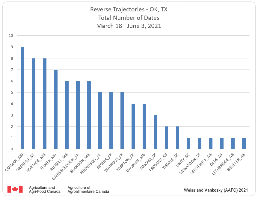
c. Oklahoma and Texas – The majority of these trajectories have passed over Manitoba and eastern Saskatchewan (Fig. 6). This week there were no trajectories (compared to 51 last week) originating in Oklahoma or Texas that passed over the prairies (Fig. 7).
Figure 6. Total number of reverse trajectories originating across Oklahoma and Texas and have crossed specific prairie locations between March 18 and June 3, 2021.Figure 7. The total number of dates with reverse trajectories originating over Oklahoma and Texas and have crossed the prairies between March 24 and June 3, 2021.
d. Kansas and Nebraska – Similar to results for Oklahoma and Texas, the majority of these trajectories crossed Manitoba and eastern Saskatchewan (Fig. 8). This week there was one trajectory that originated in Kansas or Nebraska that passed over Carman, Manitoba (Fig. 9). Relative to the reverse trajectories associated with Oklahoma and Texas, the trajectories from Kansas and Nebraska have crossed further into Alberta (Fig. 9).
Figure 8. Total number of reverse trajectories originating across Kansas and Nebraska and have crossed specific prairie locations between March 18 and June 3, 2021.Figure 9. The total number of dates with reverse trajectories originating over Kansas and Nebraska and have crossed the prairies between March 24 and June 3, 2021.
2. FORWARD TRAJECTORIES (FT) a. Continuing a trend that began last week, this week there was a decrease in the number of forward trajectories that were predicted to cross the prairies (Fig. 10). The dates on the graph report when the trajectories originated in the USA (blue bars). These trajectories generally require 3-5 days to enter the prairies (red line). The data suggests that, compared to this week, there will be decreased potential for the introduction of DBM to the prairies.
Figure 10. The average number (based on a 5-day running average) of forward trajectories that were predicted to cross the prairies for the period of May 15-June 3, 2021.
Access background information for how and why wind trajectories are monitored in this post.
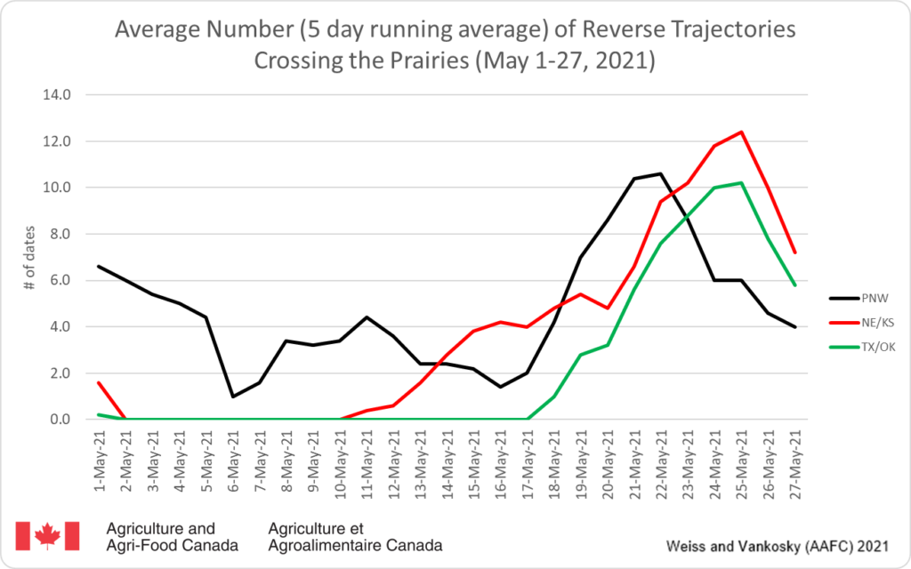
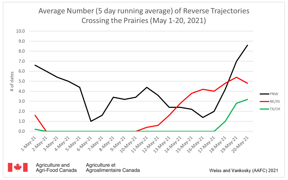
1. REVERSE TRAJECTORIES (RT) Since May 1, 2021 the majority of reverse trajectories that have crossed the prairies originated from the Pacific Northwest (Idaho, Oregon and Washington). For the past two weeks there have been an increasing number of reverse trajectories that moved north from Texas, Oklahoma, Kansas and Nebraska (Fig. 1). Compared to previous years, the number incoming trajectories (May) has increased. Though these US regions can be a source of diamondback moths, the ECCC models predict air movement, not actual occurrence of diamondback moths. It should also be noted that host plants of diamondback moth include all plants in the Brassicacea family, including cruciferous weeds and volunteer canola. These plants are suitable hosts until canola emerges.
Figure 1. The average number (based on a 5 day running average) of reverse trajectories that have crossed the prairies for the period of May 1 – 27 2021.
a. Pacific Northwest (Idaho, Oregon, Washington) – This week there have been 36 trajectories (44 last week) that have crossed Alberta, Manitoba and Saskatchewan. In previous years, the majority of Pacific Northwest reverse trajectories usually have been reported to pass over southern Alberta. This growing season, PNW trajectories have crossed all parts of the prairies (Fig. 2). Compared to this time last year there has been a significant increase in the number of trajectories that have crossed Manitoba and eastern Saskatchewan.
Figure 2. Total number of dates with reverse trajectories originating over Pacific Northwest (Idaho, Oregon, and Washington) and have crossed the prairies between March 24 and May 27, 2021.
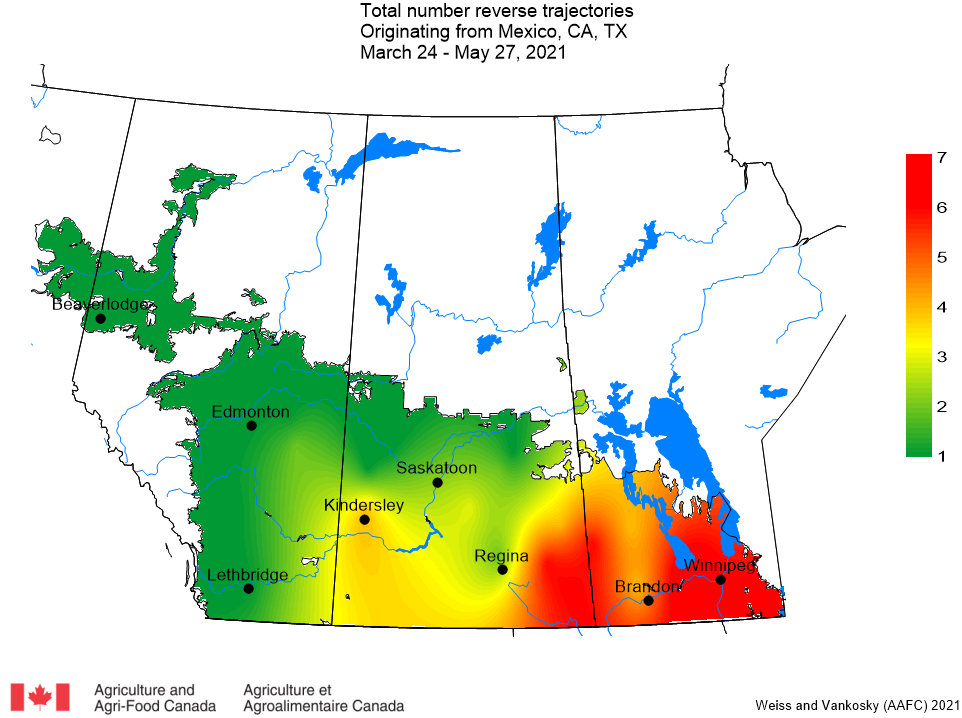
b. Mexico and southwest USA (Texas, California) – Compared to previous years, there has been a noticeable increase in number of trajectories from the southern US. This week there have been 54 trajectories (15 last week) that originated in Mexico and the southwestern US that have crossed the prairies (Fig. 3).
Figure 3. The total number of dates with reverse trajectories originating over Mexico, California and Texas and have crossed the prairies between March 24 and May 27, 2021.
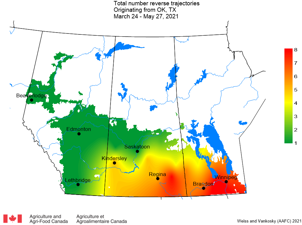
c. Oklahoma and Texas – This week there have been 51 trajectories (16 last week) that have passed over Manitoba, Saskatchewan and eastern Alberta that originated in Oklahoma or Texas (Fig. 4).
Figure 4. The total number of dates with reverse trajectories originating over Oklahoma and Texas and have crossed the prairies between March 24 and May 27, 2021.
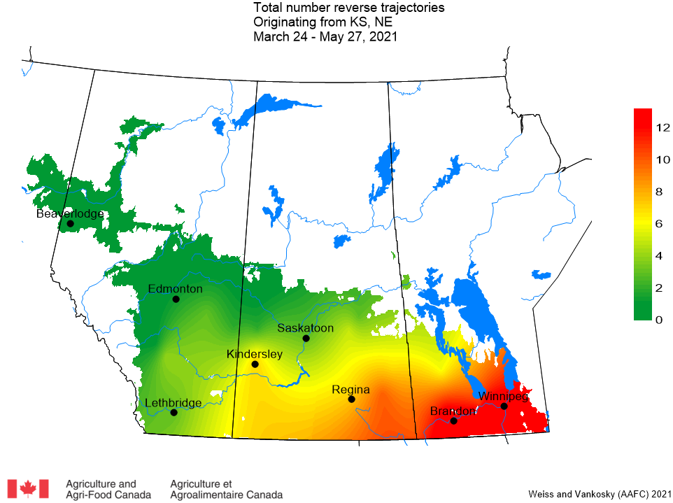
d. Kansas and Nebraska – This week there have been 63 trajectories (35 last week) that originated in Kansas or Nebraska that have passed over the prairies (Fig. 5). Relative to the reverse trajectories associated with Oklahoma and Texas, the trajectories from Kansas and Nebraska have crossed further into Alberta.
Figure 5. The total number of dates with reverse trajectories originating over Kansas and Nebraska and have crossed the prairies between March 24 and May 27, 2021.
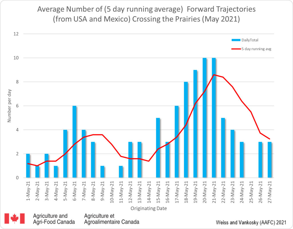
2. FORWARD TRAJECTORIES (FT) a. Forward trajectories, originating from Mexico and USA, have crossed a number of prairie locations since May 1, 2021. This week there has been a decrease in the number of trajectories that are predicted to cross the prairies (Fig. 6). The dates on the graph report when the trajectories originated in the USA (blue bars). These trajectories generally require 3-5 days to enter the prairies (red line). The data suggests that, compared to this week, there may be increased potential for the introduction of DBM to the prairies.
Figure 6. The average number (based on a 5-day running average) of forward trajectories that have crossed the prairies for the period of May 1- 27, 2021.
Access background information for how and why wind trajectories are monitored in this post.
1. REVERSE TRAJECTORIES (RT) Since May 1, 2021 the majority of reverse trajectories that have crossed the prairies originated from the Pacific Northwest (Idaho, Oregon and Washington). This week there have been an increasing number of reverse trajectories that moved north from Texas, Oklahoma and Kansas and Nebraska (Fig. 1). Though these US regions can be a source of diamondback moths, the ECCC models predict air movement, not actual occurrence of diamondback moths. It should also be noted that host plants of diamondback moth include all plants in the Brassicacea family, including cruciferous weeds and volunteer canola. These plants are suitable hosts until canola emerges.
Figure 1. The average number (based on a 5 day running average) of reverse trajectories that have crossed the prairies for the period of May 1- 20, 2021.
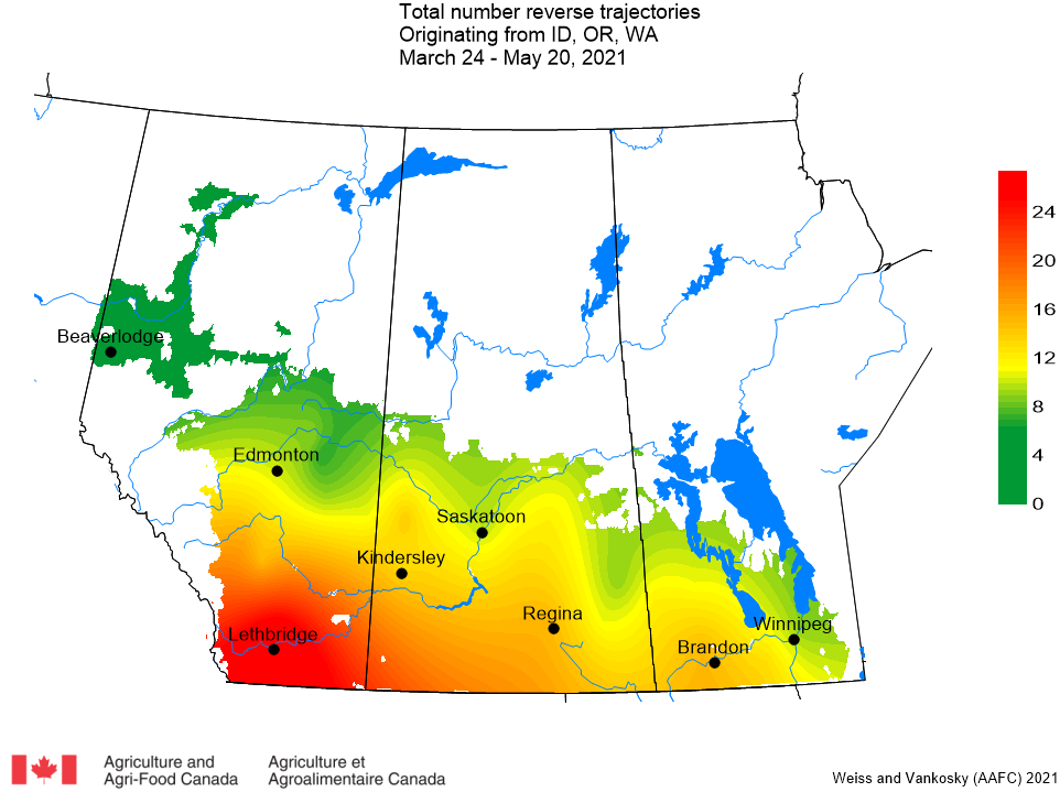
a. Pacific Northwest (Idaho, Oregon, Washington) – This week there have been 44 trajectories (27 last week) that have crossed Alberta, Manitoba, and Saskatchewan. The majority of Pacific Northwest reverse trajectories usually have been reported to pass over southern Alberta. This growing season, PNW trajectories have crossed all of the prairies (Fig. 2).
Figure 2. Total number of dates with reverse trajectories originating over Pacific Northwest (Idaho, Oregon, and Washington) and have crossed the prairies between March 24 and May 20, 2021.
b. Mexico and southwest USA (Texas, California) – This week there have been 15 trajectories that originated in Mexico and the southwestern US that have crossed Manitoba and Saskatchewan.
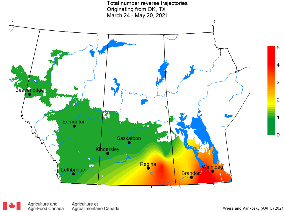
c. Oklahoma and Texas – This week there have been 16 trajectories that have passed over Manitoba and Saskatchewan (Fig. 3) that originated in Oklahoma or Texas. These are the first trajectories, that originated over Oklahoma and Texas, to enter the prairies during the month of May.
Figure 3. The total number of dates with reverse trajectories originating over Oklahoma and Texas and have crossed the prairies between March 24 and May 20, 2021.
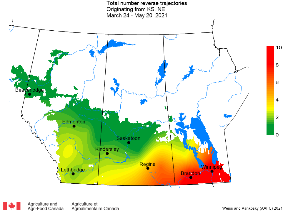
d. Kansas and Nebraska – This week there have been 35 trajectories (8 last week) that originated in Kansas or Nebraska that have passed over Manitoba and Saskatchewan (Fig. 4).
Figure 4. The total number of dates with reverse trajectories originating over Kansas and Nebraska and have crossed the prairies between March 24 and May 20, 2021.
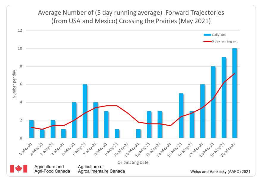
2. FORWARD TRAJECTORIES (FT) a. Forward trajectories, originating from Mexico and USA, have crossed a number of prairie locations since May 1, 2021. This week, there has been a steady increase in the number of trajectories that are predicted to cross the prairies (Fig. 5). The dates on the graph report when the trajectories originated in the USA (blue bars). These trajectories generally require 3-5 days to enter the prairies (red line). The data suggests that, compared to this week, there may be increased potential for the introduction of DBM to the prairies.
Figure 5. The average number (based on a 5 day running average) of forward trajectories that have crossed the Canadian prairies for the period of May 1- 20, 2021.
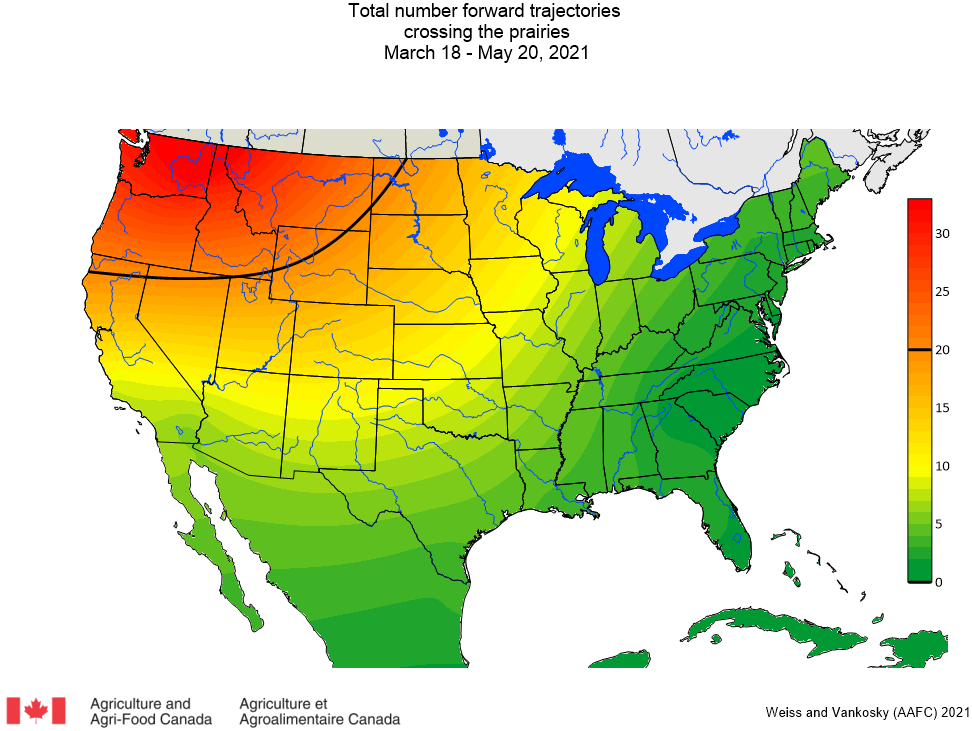
The following map presents the total number of forward trajectories that have crossed the Canadian prairies (since March 24, 2021) (Fig. 6). Results indicate that the greatest number of forward trajectories entering Canada originated from the Pacific Northwest (Idaho, Oregon, Washington).
Figure 6. The total number of dates with forward trajectories, originating from various regions of the United States and Mexico, crossed the prairies between March 24 and May 20, 2021.
Earlier in the week, an Alert related to wind trajectories assessed over May 18-19, 2021, was shared by the PPMN. It communicated the anticpated arrival of several air masses arriving across the Canadian prairies over the next few days that originated from multiple areas of USA. Remember, the current WEEKLY REPORT (above) summarizes daily data over a longer, more comprehensive period.
Access background information for how and why wind trajectories are monitored in this earlier post.
Alert: Yesterday and today ECCC models produced results that suggest a number of RT’s for prairie locations. Compared to previous dates, the ECCC model output predicts that trajectories are passing almost the entire prairie region over a very short period of time. The weather forecast may result in downward movement of DBM.
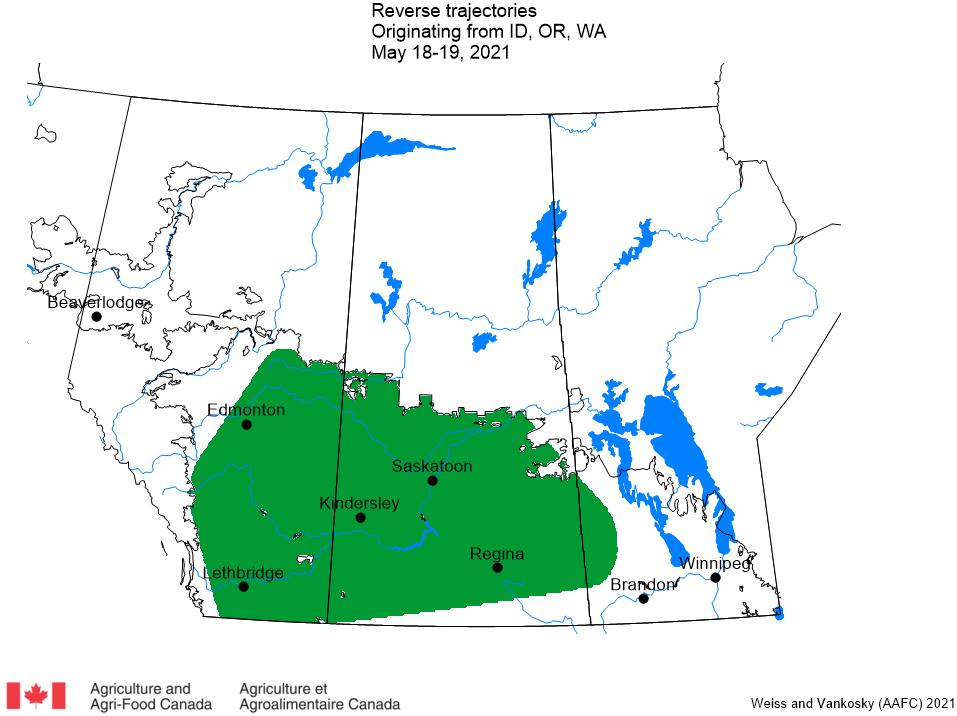
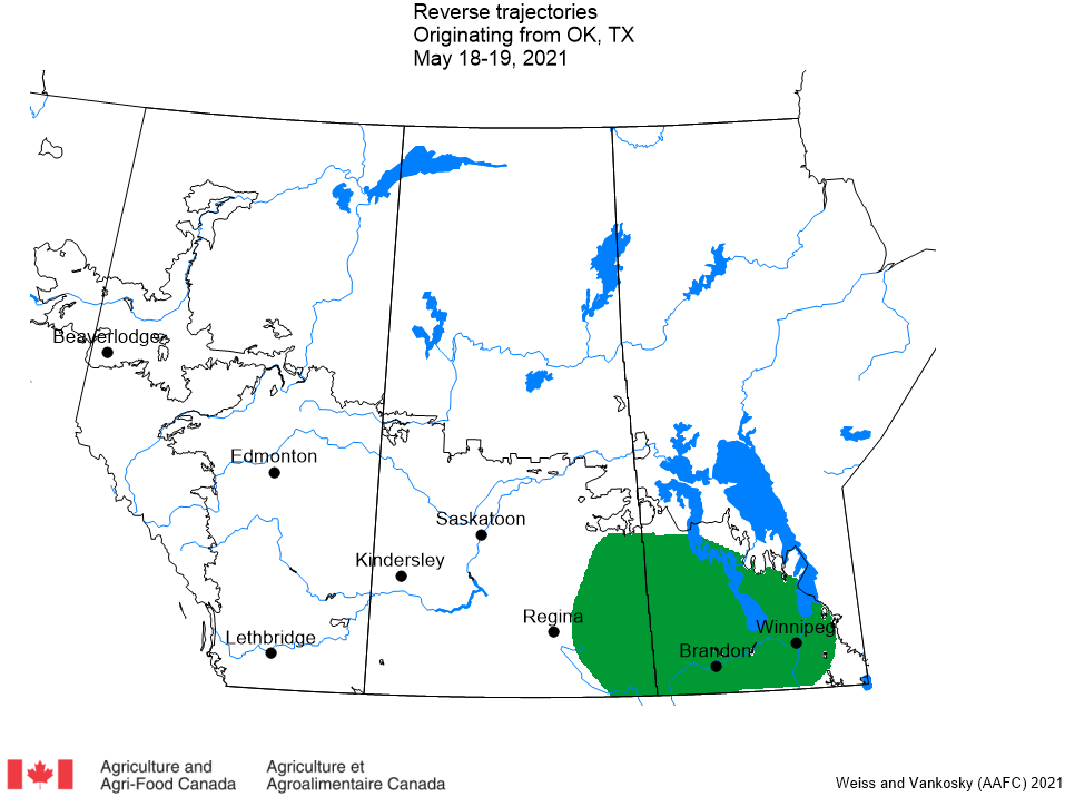
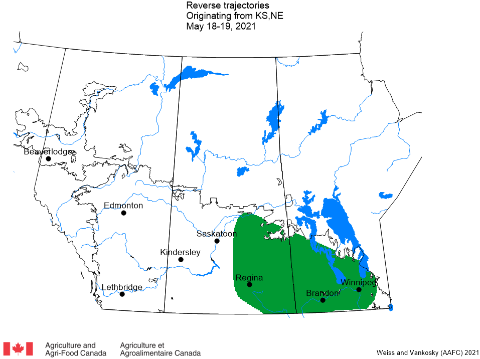
Details: There has been a significant increase in the number of trajectories, originating over a number of states in the USA, that have crossed the prairies (Fig. 1). These air currents may introduce diamondback moths to the prairies. ECCC trajectory models indicate that air trajectories, originating over the Pacific Northwest (Idaho, Oregon, Washington), have crossed Alberta, Saskatchewan and western Manitoba (Fig. 2). Trajectories originating over Texas and Oklahoma have passed over eastern Saskatchewan and Manitoba (Fig. 3). A third group of trajectories, originating across Kansas and Nebraska have also crossed eastern Saskatchewan and Manitoba (Fig. 4).
Though these US regions can be a source of diamondback moths, the ECCC models predict air movement, not actual occurrence of diamondback moths. It should also be noted that host plants of diamondback moth include all plants in the Brassicaceae family, including cruciferous weeds and volunteer canola. These plants are suitable hosts until canola emerges.
Action: The ECCC model output predicts that trajectories are passing almost the entire prairie region over a very short period of time. Areas highlighted in green in Figures 2, 3, and 4 of this alert may receive downward movement of DBM very shortly. The presence of any Brassicaceae plant will provide a host for incoming DBM so scout volunteers and emerging canola. If DBM were carried north on air currents it may take a few days for DBM to show up in traps.
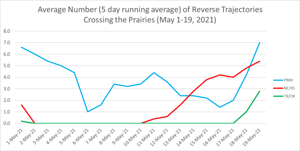
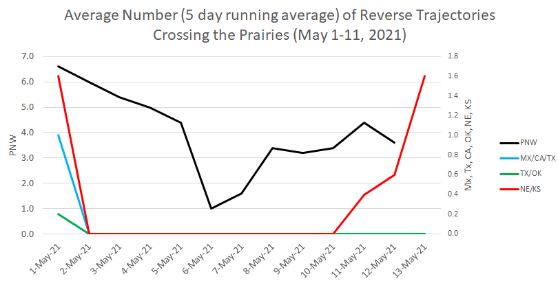
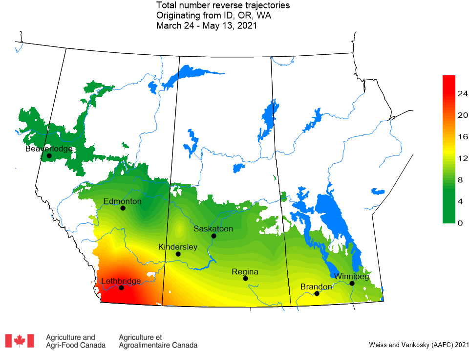
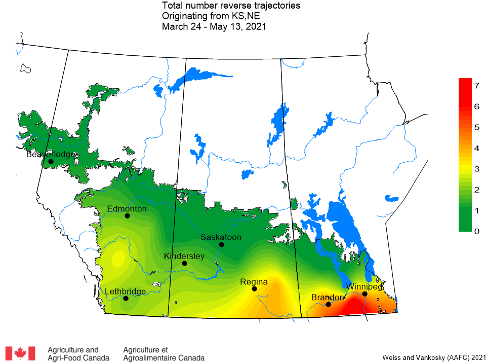
Figure 1. Summary of the average number (5 day running average) of reverse trajectories that have crossed the Canadian prairies (May 1-19, 2021) Figure 2. The green region indicates the potential for introduction of diamondback moths from the Pacific Northwest (Idaho, Oregon, and Washington) to the Canadian prairies (May 18-19, 2021).Figure 3. The green region indicates the potential for introduction of diamondback moths from Texas and Oklahoma to the Canadian prairies (May 18-19, 2021). Figure 4. The green region indicates the potential for introduction of diamondback moths from Kansas and Nebraska to the Canadian prairies (May 18-19, 2021).
Agriculture and Agri-Food Canada (AAFC) and Environment and Climate Change Canada (ECCC) have been working together to study the potential of trajectories for monitoring insect movements since the late 1990s. Trajectory models are used to deliver an early-warning system for the origin and destination of migratory invasive species, such as diamondback moth. In addition, plant pathologists have shown that trajectories can assist with the prediction of plant disease infestations and are also beginning to utilize these same data. We receive two types of model output from ECCC: reverse trajectories and forward trajectories.
‘Reverse trajectories’ refer to air currents that are tracked back in time from specified Canadian locations over a five-day period prior to their arrival date. Of particular interest are those trajectories that, prior to their arrival in Canada, originated over northwestern and southern USA and Mexico, anywhere diamondback moth populations overwinter and adults are actively migrating. If diamondback adults are present in the air currents that originate from these southern locations, the moths may be deposited on the Prairies at sites along the trajectory, depending on the local weather conditions at the time that the trajectories pass over our area (e.g. rain showers, etc.). Reverse trajectories are the best available estimate of the ”true” 3D wind fields at a specific point. They are based on observations, satellite and radiosonde data.
‘Forward trajectories’ have a similar purpose; however, the modeling process begins at sites in USA & Mexico. The model output predicts the pathway of a trajectory. Again, of interest to us are the winds that eventually end up passing over the Prairies.
Agriculture and Agri-Food Canada (AAFC) and Environment and Climate Change Canada (ECCC) have been working together to study the potential of trajectories for monitoring insect movements since the late 1990s. Trajectory models are used to deliver an early-warning system for the origin and destination of migratory invasive species, such as diamondback moth. Read a brief overview of this strategy plus the definitions and applications of both ‘Reverse’ and ‘Forward’ trajectories.
1. REVERSE TRAJECTORIES (RT) Since May 1, 2021, the majority of reverse trajectories crossing the prairies originated from the Pacific Northwest (Idaho, Oregon and Washington). This week, an increasing number of reverse trajectories have been moving north from Kansas and Nebraska (Fig. 1).
Figure 1. The average number (based on a 5-day running average) of reverse trajectories (RTs) that have crossed the prairies for the period of May 1-13, 2021.
a. Pacific Northwest (Idaho, Oregon, Washington) – The majority of Pacific Northwest reverse trajectories have been reported to pass over southern Alberta (Fig. 2).
Figure 2. Total number of dates with reverse trajectories originating over the Pacific Northwest (PNW including Idaho, Oregon, and Washington) that have crossed the prairies between March 24 and May 13, 2021.
b. Mexico and southwest USA (Texas, California) – Since last week there have not been any trajectories that originated in these areas that have crossed the prairies.
c. Oklahoma and Texas – Since last week there have not been any trajectories originating in Oklahoma or Texas that have crossed the prairies.
d. Kansas and Nebraska – This week reverse trajectories were reported for Alberta (Andrew, Sedgewick), Saskatchewan (Gainsborough, Grenfell, Kindersley, Regina, Yorkton) and Manitoba (Brandon) (Fig. 3).
Figure 3. The total number of dates with reverse trajectories originating over Kansas and Nebraska that have crossed the prairies between March 24 and May 13, 2021.
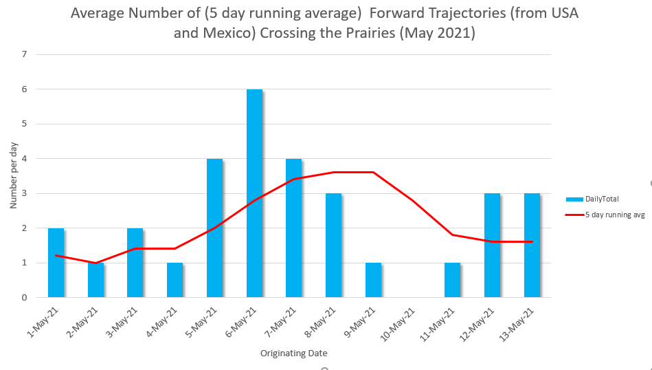
2. FORWARD TRAJECTORIES (FT) Forward trajectories, originating from Mexico and USA have crossed a number of prairie locations since May 1, 2021. Based on average totals (averaged across a five day period), the greatest number of forward trajectories were observed to originate between May 5 and 8 (blue bars) and entered the prairies between May 6-9 (Fig. 4).
Figure 4. The average number (based on a 5 day running average) of forward trajectories that have crossed the prairies for the period of May 1- 13, 2021.
The following map presents the total number of dates (since March 24, 2021) with forward trajectories that have crossed the Canadian prairies (Fig. 5). Results indicate that the greatest number of forward trajectories entering Canada originated from the Pacific Northwest (Idaho, Oregon, Washington).
Figure 5. The total number of dates with forward trajectories, originating from various regions of the United States and Mexico, that crossed the prairies between March 24 and May 13, 2021.
ECCC trajectory models indicate that air trajectories, originating over the Pacific Northwest (Idaho, Oregon, Washington), have crossed one Saskatchewan location (Unity) and a number of Alberta locations including Lethbridge, Beiseker, Olds, Provost, Vegreville, Andrew, Grande Prairie, Rycroft and Fort Vermillion.
Access this DAILY one-page report to learn more. Albertans and Saskatchewanians please take note!
Areas highlighted green in this alert may receive incoming winds from the Pacific Northwest of the USA very shortly! Remember, host plants of diamondback moth include all plants in the Brassicacea family, including cruciferous weeds and volunteer canola. These plants are suitable hosts until canola emerges.
Environment and Climate Change Canada (ECCC) trajectory models indicate that air trajectories, originating over the Pacific Northwest (Idaho, Oregon, Washington), have crossed a number of Alberta locations including Lethbridge, Beiseker, Olds, Manning, Rycroft, and Wanham.
Access this special one-page alert to learn more. Albertans please take note!
Action: Areas highlighted green in this alert may receive incoming winds from the Pacific Northwest of the USA very shortly so please deploy diamondback pheromone traps as soon as possible!
Agriculture and Agri-Food Canada (AAFC) and Environment and Climate Change Canada (ECCC) have been working together to study the potential of trajectories for monitoring insect movements since the late 1990s. Trajectory models are used to deliver an early-warning system for the origin and destination of migratory invasive species, such as diamondback moth.
Agriculture and Agri-Food Canada (AAFC) and Environment and Climate Change Canada (ECCC) have been working together to study the potential of trajectories for monitoring insect movements since the late 1990s.
Agriculture and Agri-Food Canada (AAFC) and Environment and Climate Change Canada (ECCC) have been working together to study the potential of trajectories for monitoring insect movements since the late 1990s.
Agriculture and Agri-Food Canada (AAFC) and Environment and Climate Change Canada (ECCC) have been working together to study the potential of trajectories for monitoring insect movements since the late 1990s.
Agriculture and Agri-Food Canada (AAFC) and Environment and Climate Change Canada (ECCC) have been working together to study the potential of trajectories for monitoring insect movements since the late 1990s.
Agriculture and Agri-Food Canada (AAFC) and Environment and Climate Change Canada (ECCC) have been working together to study the potential of trajectories for monitoring insect movements since the late 1990s.
Agriculture and Agri-Food Canada (AAFC) and Environment and Climate Change Canada (ECCC) have been working together to study the potential of trajectories for monitoring insect movements since the late 1990s.
Agriculture and Agri-Food Canada (AAFC) and Environment and Climate Change Canada (ECCC) have been working together to study the potential of trajectories for monitoring insect movements since the late 1990s.
Agriculture and Agri-Food Canada (AAFC) and Environment and Climate Change Canada (ECCC) have been working together to study the potential of trajectories for monitoring insect movements since the late 1990s.
Agriculture and Agri-Food Canada (AAFC) and Environment and Climate Change Canada (ECCC) have been working together to study the potential of trajectories for monitoring insect movements since the late 1990s.
Agriculture and Agri-Food Canada (AAFC) and Environment and Climate Change Canada (ECCC) have been working together to study the potential of trajectories for monitoring insect movements since the late 1990’s.
In a continuing effort to produce timely information, the wind trajectory reports are available in two forms:
DAILY REPORTS, as they can be generated, are accessible as a downloadable PDF file on this page.
Agriculture and Agri-Food Canada (AAFC) and Environment and Climate Change Canada (ECCC) have been working together to study the potential of trajectories for monitoring insect movements since the late 1990s.
In a continuing effort to produce timely information, the wind trajectory reports are available in two forms:
DAILY REPORTS, as they can be generated, are accessible as a downloadable PDF file on this page.
Agriculture and Agri-Food Canada (AAFC) and Environment and Climate Change Canada (ECCC) have been working together to study the potential of trajectories for monitoring insect movements since the late 1990s. Trajectory models are used to deliver an early-warning system for the origin and destination of migratory invasive species, such as diamondback moth. In addition, plant pathologists have shown that trajectories can assist with the prediction of plant disease infestations and are also beginning to utilize these same data. We receive two types of model output from ECCC: reverse trajectories and forward trajectories.
‘Reverse trajectories’ (RT) refer to air currents that are tracked back in time from specified Canadian locations over a five-day period prior to their arrival date. Of particular interest are those trajectories that, prior to their arrival in Canada, originated over northwestern and southern USA and Mexico, anywhere diamondback moth populations overwinter and adults are actively migrating. If diamondback adults are present in the air currents that originate from these southern locations, the moths may be deposited on the Prairies at sites along the trajectory, depending on the local weather conditions at the time that the trajectories pass over our area (e.g. rain showers, etc.). Reverse trajectories are the best available estimate of the ”true” 3D wind fields at a specific point. They are based on observations, satellite and radiosonde data.
‘Forward trajectories’ (FT) have a similar purpose; however, the modelling process begins at sites in USA & Mexico. The model output predicts the pathway of a trajectory. Again, of interest to us are the winds that eventually end up passing over the Prairies.
Ross Weiss (AAFC), Meghan Vankosky (AAFC) and Serge Trudel (ECCC)
DATE: APRIL 30, 2019
1. Reverse trajectories (RT)
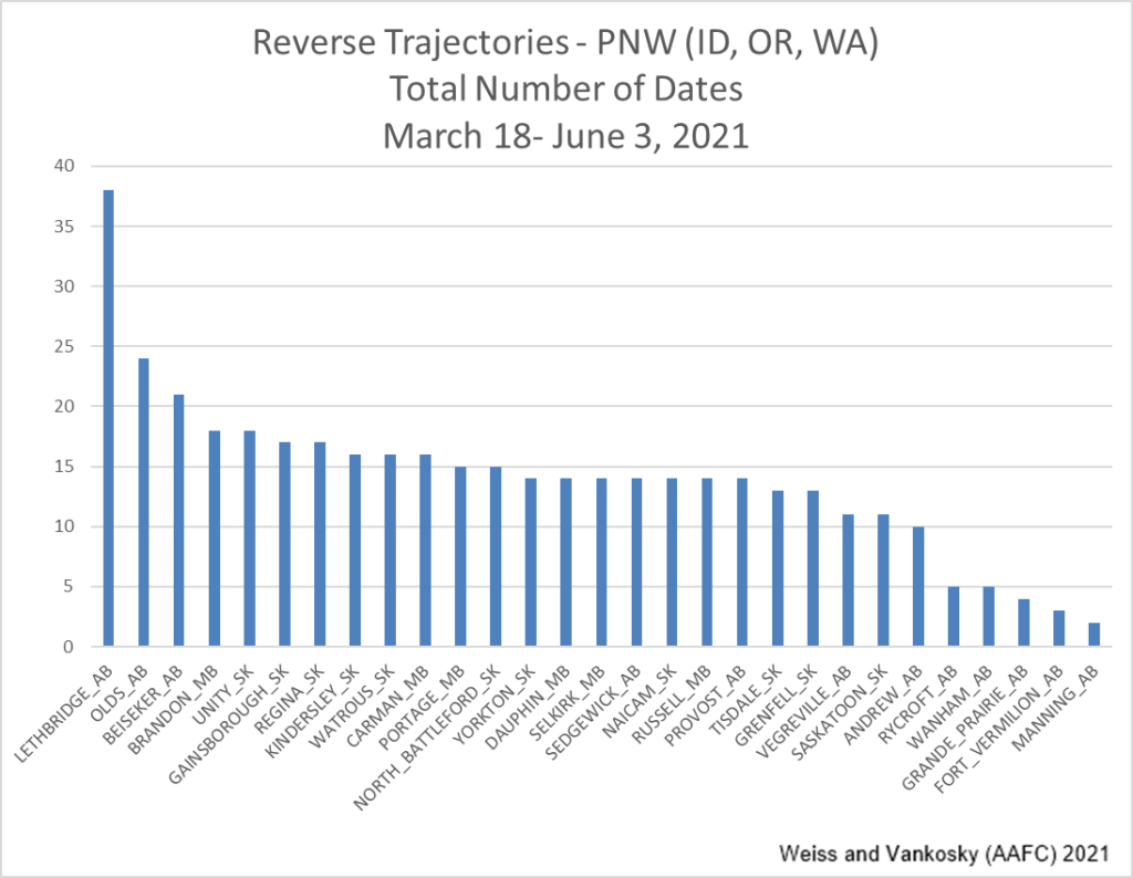
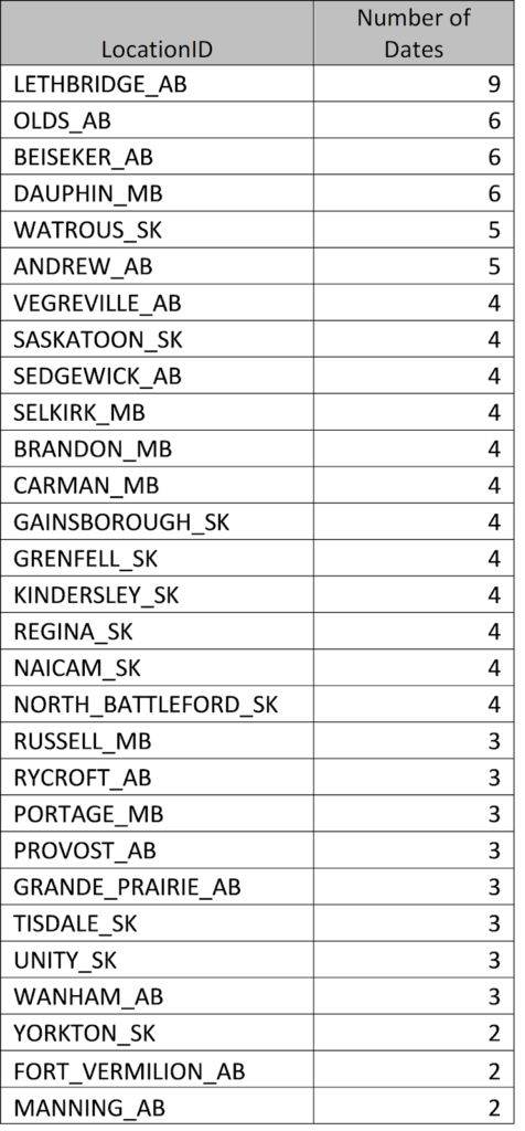
a. Pacific Northwest (PNW) – For the period of April 24-30 there have been 18 RTs (originating over ID, OR and WA) that have crossed over prairie locations. By comparison, for the period of April 17-23 there were 51 RT’s. The majority PNW RTs have been reported to pass over southern AB. Since March 23rd Lethbridge AB has reported the highest number of PNW RTs (n=22), Beiseker AB (n=15) and Olds AB (n=31).
Figure 1. Daily total number of reverse trajectories (RTs) originating over Idaho, Oregon, and Washington that have crossed the Canadian prairies as of April 30, 2019. Figure 2. Total number of dates with PNW reverse trajectories originating over Idaho, Oregon, and Washington that have crossed the Canadian prairies (since March 23, 2019). Figure 3. List of PNW (Idaho, Oregon, and Washington) reverse trajectories that have crossed the prairies (since March 23, 2019).
b. Mexico and SW USA (TX, CA) – No trajectories, originating over Mexico or southwest USA have crossed the prairies for the period of April 24-30, 2019. Since March 23, 2019 there have been 5 reverse trajectories that originated over Mexico, CA and TX. All five occurred on April 7.
c. Texas and Oklahoma – No trajectories, originating over TX or OK have crossed the prairies for the period of April 24-30, 2019. Since March 23, 2019 there have been 18 reverse trajectories that have originated over OK and TX. Most of these trajectories have crossed eastern SK and MB.
2. Forward trajectories (FT) –
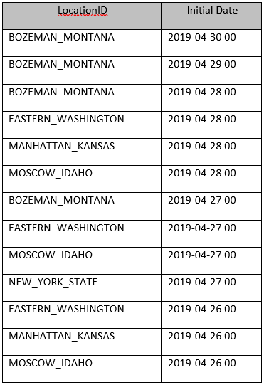
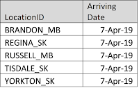
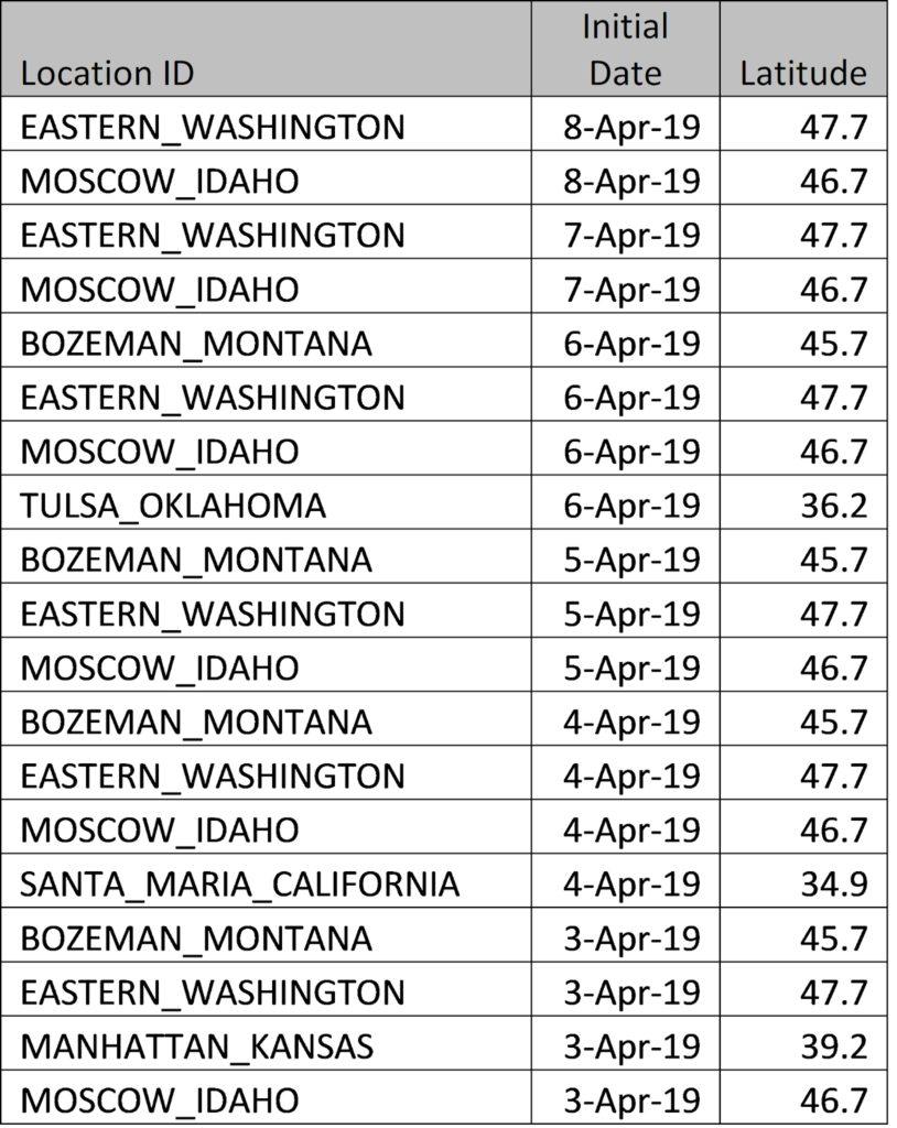
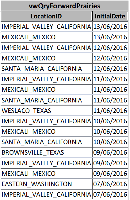
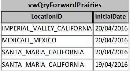
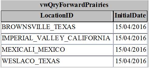
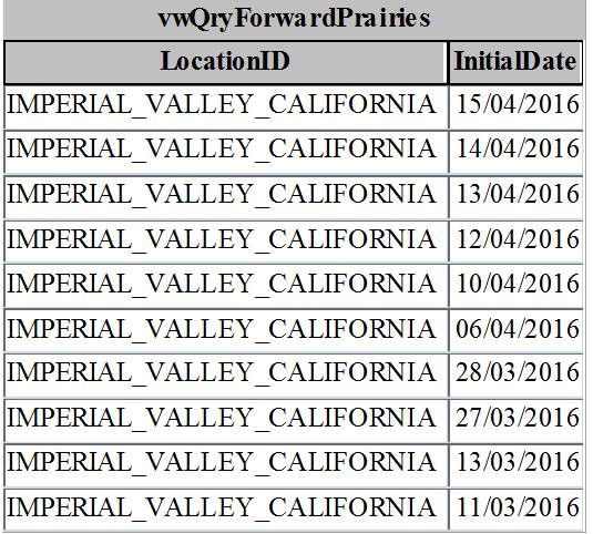
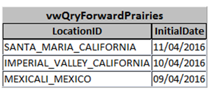
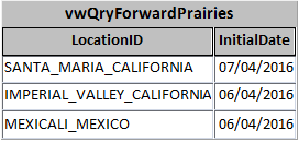
The following table reports the origin of forward trajectories predicted to cross the prairies over the next five days (Note: ‘InitialDate’ refers to when the forward trajectory crossed the source location. Trajectories are predicted to cross prairie locations within five days of the initial date).
In a continuing effort to produce timely information, wind trajectory reports will be available both DAILY and WEEKLY:
DAILY REPORTS, as they can be generated, will be put up as a downloadable PDF file on this page.
Agriculture and Agri-Food Canada (AAFC) and Environment and Climate Change Canada (ECCC) have been working together to study the potential of trajectories for monitoring insect movements since the late 1990s. Trajectory models are used to deliver an early-warning system for the origin and destination of migratory invasive species, such as diamondback moth. In addition, plant pathologists have shown that trajectories can assist with the prediction of plant disease infestations and are also beginning to utilize these same data. We receive two types of model output from ECCC: reverse trajectories and forward trajectories.
‘Reverse trajectories’ (RT) refer to air currents that are tracked back in time from specified Canadian locations over a five-day period prior to their arrival date. Of particular interest are those trajectories that, prior to their arrival in Canada, originated over northwestern and southern USA and Mexico, anywhere diamondback moth populations overwinter and adults are actively migrating. If diamondback adults are present in the air currents that originate from these southern locations, the moths may be deposited on the Prairies at sites along the trajectory, depending on the local weather conditions at the time that the trajectories pass over our area (e.g. rain showers, etc.). Reverse trajectories are the best available estimate of the ”true” 3D wind fields at a specific point. They are based on observations, satellite and radiosonde data.
‘Forward trajectories’ (FT) have a similar purpose; however, the modelling process begins at sites in USA & Mexico. The model output predicts the pathway of a trajectory. Again, of interest to us are the winds that eventually end up passing over the Prairies.
Ross Weiss (AAFC), Meghan Vankosky (AAFC) and Serge Trudel (ECCC)
DATE: APRIL 24, 2019
Reverse trajectories (RT)
a. Pacific Northwest (PNW) – For the period of April 17-23, 2019, there have been 55 RT’s (originating over ID, OR and WA) that have crossed over prairie locations (Figs. 1 and 2). By comparison, for the period of April 10-16, 2019, there were 31 RT’s. The majority PNW RT’s have been reported to pass over southern AB. Since March 23rd, Lethbridge AB has reported the highest number of PNW RT’s (n=20), Beiseker AB (n=15) and Gainsborough SK (n=11).
Figure 1. Daily total number of reverse trajectories originating over ID, OR, and WA that have crossed the prairies.Figure 2. Total number of dates with PNW reverse trajectories originating over ID, OR, and WA that have crossed the prairies (since March 23, 2019).
b. Mexico and SW USA (TX, CA) – No trajectories, originating over Mexico or southwest USA have crossed the prairies for the period of April 17-23, 2019. Since March 23, 2019 there have been 5 reverse trajectories that originated over Mexico, CA and TX. All five occurred on April 7, 2019.
c. Texas and Oklahoma – No trajectories, originating over TX or OK have crossed the prairies for the period of April 17-23, 2019. Since March 23, 2019 there have been 18 reverse trajectories that have originated over OK and TX (Fig. 3). Most of these trajectories have crossed eastern SK and MB.
Figure 3. Total number of dates with reverse trajectories originating over OK and TX that have crossed the prairies (since March 23, 2019).
d. Nebraska and Kansas – No trajectories, originating over KS or NE have crossed the prairies for the period of April 17-23, 2019. Since March 23, 2019 there have been 18 reverse trajectories that have originated over KS and NE (Fig. 4).
Figure 4. Total number of dates with reverse trajectories originating over KS and NE that have crossed the prairies (since March 23, 2019).
In a continuing effort to produce timely information, wind trajectory reports will be available both DAILY and WEEKLY:
DAILY REPORTS, as they can be generated, will be put up as a downloadable PDF file on this page.
Agriculture and Agri-Food Canada (AAFC) and Environment and Climate Change Canada (ECCC) have been working together to study the potential of trajectories for monitoring insect movements since the late 1990s.
In a continuing effort to produce timely information, the wind trajectory reports will be available both DAILY and WEEKLY:
DAILY REPORTS, as they can be generated, will be put up as a downloadable PDF file on this page.
Agriculture and Agri-Food Canada (AAFC) and Environment and Climate Change Canada (ECCC) have been working together to study the potential of trajectories for monitoring insect movements since the late 1990s. Trajectory models are used to deliver an early-warning system for the origin and destination of migratory invasive species, such as diamondback moth. In addition, plant pathologists have shown that trajectories can assist with the prediction of plant disease infestations and are also beginning to utilize these same data. We receive two types of model output from ECCC: reverse trajectories and forward trajectories.
‘Reverse trajectories’ (RT) refer to air currents that are tracked back in time from specified Canadian locations over a five-day period prior to their arrival date. Of particular interest are those trajectories that, prior to their arrival in Canada, originated over northwestern and southern USA and Mexico, anywhere diamondback moth populations overwinter and adults are actively migrating. If diamondback adults are present in the air currents that originate from these southern locations, the moths may be deposited on the Prairies at sites along the trajectory, depending on the local weather conditions at the time that the trajectories pass over our area (e.g. rain showers, etc.). Reverse trajectories are the best available estimate of the ”true” 3D wind fields at a specific point. They are based on observations, satellite and radiosonde data.
‘Forward trajectories’ (FT) have a similar purpose; however, the modelling process begins at sites in USA & Mexico. The model output predicts the pathway of a trajectory. Again, of interest to us are the winds that eventually end up passing over the Prairies.
Ross Weiss (AAFC), Meghan Vankosky (AAFC) and Serge Trudel (ECCC)
DATE: APRIL 8, 2019
1. Reverse trajectories (RT): a. Pacific Northwest (PNW) – For the period of April 2-8 there have been 69 RT’s (originating over the PNW) that have crossed over prairie locations. Since March 23rd Lethbridge has reported the highest number of PNW RT’s (n=9), followed by Olds AB, Beiseker AB and Dauphin MB (n=6).
List of PNW Reverse trajectories that have crossed the prairies (Since March 23, 2019):
b. Mexico and SW USA (SW) – On April 7 the first Southwestern USA and Mexico RT’s crossed the prairies. These reverse trajectories originated over TX and CA.
The following maps present two examples of April 7, 2019 RT’s. The first map indicates that the RT crossing Tisdale originated across southern TX. The second map shows that two RT’s crossed over Regina. The red line indicates that this RT originated over southern TX. A second RT originated across central CA.
Tisdale SK, April 7, 2019
Regina SK, April 7, 2019
2. Forward trajectories (FT) –
The following table reports the origin of forward trajectories predicted to cross the prairies over the next five days. Forward trajectories, originating over Santa Maria, CA are predicted to pass over SK and MB in the next five days.
Background: Agriculture and Agri-Food Canada (AAFC) and Environment and Climate Change Canada (ECCC) have been working together to study the potential of trajectories to deliver an early-warning system for the origin and destination of migratory invasive agricultural pests.
We receive two types of model output from ECCC: reverse trajectories (RT) and forward trajectories (FT):
(i) ‘Reverse trajectories’ (RT) refer to air currents that are tracked back in time from specified Canadian locations over a five-day period prior to their arrival date.
(ii) ‘Forward trajectories’ (FT) have a similar purpose; however, the modelling process begins at sites in USA and Mexico. The model output predicts the pathway of a trajectory. Again, of interest are the winds that eventually end up passing over the Prairies.
Current Data
Since April 1. 2018, the majority of Pacific Northwest (PNW) air currents have crossed over southern AB (Fig. 1). The cumulative number of wind dispersal events for June 1 – 11, 2018 (181) is greater than the long term (2007 – 2017) average (98).
Figure 1. Total reverse trajectories (originating from US – PNW) April 1 – June 11, 2018.
Since April 1, the majority of air currents from southwest USA and Mexico have crossed over eastern SK and western MB (Fig. 2). So far there have been 18 RT’s (June 1 – 11, 2018) and compares with 2017 (3) and the long term average (24).
Figure 2. Total number of reverse trajectories (originating from southern USA) April 1 – June 11, 2018.
Background: Agriculture and Agri-Food Canada (AAFC) and Environment and Climate Change Canada (ECCC) have been working together to study the potential of trajectories to deliver an early-warning system for the origin and destination of migratory invasive agricultural pests.
We receive two types of model output from ECCC: reverse trajectories (RT) and forward trajectories (FT):
(i) ‘Reverse trajectories’ (RT) refer to air currents that are tracked back in time from specified Canadian locations over a five-day period prior to their arrival date.
(ii) ‘Forward trajectories’ (FT) have a similar purpose; however, the modelling process begins at sites in USA and Mexico. The model output predicts the pathway of a trajectory. Again, of interest are the winds that eventually end up passing over the Prairies.
Current Data The number of Reverse Trajectories (RTs), crossing the prairies in May 2018, was lower than the long term average (2007 – 2017). The total number of incoming trajectories (sum of Pacific Northwest and southwest USA/Mexico) for 2018 was less than similar values for 2017 and 2007 – 2017. Based on RTs by region, the number of RTs from the Pacific Northwest (PNW) was less than 2007 – 2017 and 2017. To date, the RTs originating in the southwest USA/Mexico in 2018, have been greater in number than in 2017 and less than the long term average (Fig. 1).
Figure 1. Total number of reverse trajectories by geographic region (Pacific Northwest and Mexico and the southwest USA) for May 2018.
Background: Agriculture and Agri-Food Canada (AAFC) and Environment and Climate Change Canada (ECCC) have been working together to study the potential of trajectories to deliver an early-warning system for the origin and destination of migratory invasive agricultural pests.
We receive two types of model output from ECCC: reverse trajectories (RT) and forward trajectories (FT):
(i) ‘Reverse trajectories’ (RT) refer to air currents that are tracked back in time from specified Canadian locations over a five-day period prior to their arrival date.
(ii) ‘Forward trajectories’ (FT) have a similar purpose; however, the modelling process begins at sites in USA and Mexico. The model output predicts the pathway of a trajectory. Again, of interest are the winds that eventually end up passing over the Prairies.
Current Data
Since May 21, 2018, the number of incoming trajectories (RTs) crossing the prairies has increased, particularly from California, Texas and Mexico (Fig. 1). The increased number of reverse trajectories could result in increased introductions of insects into the prairies.
Figure 1. Daily total number of reverse trajectories, originating over the Pacific Northwest AND Southwest of the USA, that have entered the Canadian prairies (May 1-28, 2018).
Background.Agriculture and Agri-Food Canada (AAFC) and Environment and Climate Change Canada (ECCC) have been working together to study the potential of trajectories to deliver an early-warning system for the origin and destination of migratory invasive agricultural pests. We receive two types of model output from ECCC: reverse trajectories (RT) and forward trajectories (FT):
(i) ‘Reverse trajectories’ (RT) refer to air currents that are tracked back in time from specified Canadian locations over a five-day period prior to their arrival date.
(ii) ‘Forward trajectories’ (FT) have a similar purpose; however, the modelling process begins at sites in USA and Mexico. The model output predicts the pathway of a trajectory. Again, of interest are the winds that eventually end up passing over the Prairies.
Current Data
Pacific Northwest (PNW) –The total number of RT’s from the Pacific Northwest of the United States, for the period between May 1 – 22, 2018, was n=67. This was significantly less than in 2017 (n=226), as well as the long term average (n=166) (Fig. 1).
Figure 1. Daily total number of reverse trajectories originating over the Pacific Northwest of
the United States that have entered the prairies (May 1-22, 2018).
Background. Agriculture and Agri-Food Canada (AAFC) and Environment and Climate Change Canada (ECCC) have been working together to study the potential of trajectories for monitoring insect movements since the late 1990’s. Trajectory models are used to deliver an early-warning system for the origin and destination of migratory invasive species, such as diamondback moth. In addition, plant pathologists have shown that trajectories can assist with the prediction of plant disease infestations and are also beginning to utilize these same data.
We receive two types of model output from ECCC: reverse trajectories (RT) and forward trajectories (FT): (i) Reverse trajectories refer to air currents that are tracked back in time from specified Canadian locations over a five-day period prior to their arrival date. Of particular interest are those trajectories that, prior to their arrival in Canada, originated over northwestern and southern USA and Mexico, anywhere diamondback moth populations overwinter and adults are actively migrating. If diamondback adults are present in the air currents that originate from these southern locations, the moths may be deposited on the Prairies at sites along the trajectory, depending on the local weather conditions at the time that the trajectories pass over our area (e.g. rain showers, etc.). RTs are the best available estimate of 3D wind fields at a specific point. They are based on observations, satellite and radiosonde data. (ii) Forward trajectories have a similar purpose; however, the modelling process begins at sites in USA and Mexico. The model output predicts the pathway of a trajectory. Again, of interest to us are the winds that eventually end up passing over the Prairies. Current Data
Pacific Northwest (PNW) –The number of RTs, predicted to cross the prairies, has increased over the past week (Fig. 1). Though there has been an increase, results for May 1-14 predicted that 38 PNW reverse trajectories (RT) have crossed the prairies. This total is less than the average number 107 (based on 2007-2017) and well below last year’s results (155).
Figure 1. Daily total of reverse trajectories (RT) originating over the Pacific Northwest that
have entered the prairies during April 2018.
Background. Agriculture and Agri-Food Canada (AAFC) and Environment and Climate Change Canada (ECCC) have been working together to study the potential of trajectories for monitoring insect movements since the late 1990’s. Trajectory models are used to deliver an early-warning system for the origin and destination of migratory invasive species, such as diamondback moth. In addition, plant pathologists have shown that trajectories can assist with the prediction of plant disease infestations and are also beginning to utilize these same data.
We receive two types of model output from ECCC: reverse trajectories (RT) and forward trajectories (FT): (i) Reverse trajectories refer to air currents that are tracked back in time from specified Canadian locations over a five-day period prior to their arrival date. Of particular interest are those trajectories that, prior to their arrival in Canada, originated over northwestern and southern USA and Mexico, anywhere diamondback moth populations overwinter and adults are actively migrating. If diamondback adults are present in the air currents that originate from these southern locations, the moths may be deposited on the Prairies at sites along the trajectory, depending on the local weather conditions at the time that the trajectories pass over our area (e.g. rain showers, etc.). RTs are the best available estimate of 3D wind fields at a specific point. They are based on observations, satellite and radiosonde data.
(ii) Forward trajectories have a similar purpose; however, the modelling process begins at sites in USA and Mexico. The model output predicts the pathway of a trajectory. Again, of interest to us are the winds that eventually end up passing over the Prairies.
Current Data
Pacific Northwest (PNW) – The number of RTs predicted to cross the prairies from the PNW, has increased over the last few days. Model runs for May 7th predicted that seven RTs will cross over AB and SK in the next 24 hours from the PNW. Based on results for April, there have been fewer RTs in 2018 than 2017. The number of RTs were greatest across southern AB (Fig. 1). The majority of these crossed the prairies in mid-April (Fig. 2).
Figure 1. Total number of reverse trajectories, originating over the US PNW, that
has entered the prairies during April, 2018.
Figure 2. Daily total number of reverse trajectories, originating over the US PNW, that
have entered the prairies during April, 2018.
Reverse trajectories (RT) There were 139 reverse trajectories that were predicted to pass across Alberta and Saskatchewan from the Pacific Northwest between May 26 and June 8.
Forward trajectories (FT) The following map indicates the origin of forward trajectories predicted to cross the prairies over the next five days. There have been an increased number of winds that have crossed the prairies from the southwest USA and Mexico since June 1.
THE WEEK OF MAY 29, 2017: Wind trajectory data processing by AAFC-Saskatoon Staff began in April. Reverse Trajectories track arriving air masses back to their point of origin while Forward Trajectories predict favourable winds expected to arrive across the Canadian Prairies for the week of May 23, 2017: Reverse trajectories (RT) Overall, the number of RTs entering the prairies from the Pacific
Northwest has been lower than average. The map (Fig. 1) shows that the greatest number
of RTs from the Pacific Northwest continued to be across southern Alberta.
Figure 1. Number of Reverse Trajectories (RT) originating in the Pacific Northwest that
arrived at sites across the Canadian prairies from April 1-May 29, 2017.
THE WEEK OF MAY 23, 2017: Wind trajectory data processing by AAFC-Saskatoon Staff began in April. Reverse Trajectories track arriving air masses back to their point of origin while Forward Trajectories predict favourable winds expected to arrive across the Canadian Prairies for the week of May 23, 2017: Reverse trajectories (RT) Between May 16 and 23 there were 57 RT’s from the Pacific Northwest of USA that crossed the prairies. The first chart (Fig. 1) indicates site specific results for PNW RT’s for each day of the past week. Values reflect the fact that PNW RT’s were lower this week than previous weeks. The greatest number of PNW RT’s continued to be across southern AB (Fig. 2).
Figure 1. Cumulative number of Reverse Trajectories (RT) originating from the Pacific Northwest arriving across the Canadian prairies from May 16-23, 2017 (Olfert et al. 2017).
Figure 2. Number of Reverse Trajectories (RT) originating in the Pacific Northwest that arrived at sites across the Canadian prairies from April 1-May 23, 2017.
Forward trajectories (FT) No FTs originating from Mexico or southwest USA/Mexico are predicted to cross the prairies over the next 5 days. The following map provides an overview of FTs that have crossed the prairies during the 2017 growing season.
Figure 2. Total number of reverse trajectories originating from the Pacific Northwest of the USA arriving at sites across the Canadian prairies (April 1-May 23, 2017).
THE WEEK OF MAY 15, 2017: Wind trajectory data processing by AAFC-Saskatoon Staff began in April. Reverse Trajectories track arriving air masses back to their point of origin while Forward Trajectories predict favourable winds expected to arrive across the Canadian Prairies for the week of May 15, 2017: Reverse trajectories (RT) Wind trajectories have been monitored since April 1 this year. Wind patterns continue to be similar to previous weeks. The first graph (Fig. 1) indicates that winds from the Pacific Northwest (PNW) passed over Carman MB each day of the past week. Though the number of RTs increased over the past week, the overall pattern has not changed across the prairies.
Figure 1. Number of Reverse Trajectories (RT) originating in the Pacific Northwest that have arrived at sites across the Canadian prairies from May 9-15, 2017.
Figure 2 shows that the greatest number of RTs continue to be settling at sites across southern Alberta (e.g., areas highlighted red).
Figure 2. Total number of reverse trajectories originating from the Pacific Northwest of the USA arriving at sites across the Canadian prairies (April 1-May 15, 2017).
THE WEEK OF MAY 1, 2017: Wind trajectory data processing by AAFC-Saskatoon Staff began in April. Reverse Trajectories track arriving air masses back to their point of origin while Forward Trajectories predict favourable winds expected to arrive across the Canadian Prairies for the week of May 9, 2017: Reverse trajectories (RT) Wind trajectories have been monitored since April 1 this year. This week there was an increase in the number of RT winds that crossed the prairies from the Pacific Northwest (PNW) of USA. In Alberta, Grande Prairie and Beiseker had a significant increase in the number of RT winds over this past week (Fig. 1 and 2). In addition to the PNW, there were three prairie locations (Selkirk MB, Unity SK and Olds AB) that had winds originating from California and Texas.
Figure 1. Weekly cumulative counts of Reverse Trajectories (RT) from the Pacific Northwest (PNW) from May 3-9, 2017 (2017 Olfert et al.).
Figure 2. Total number of RT winds from the Pacific Northwest from April 1-May 9, 2017.
Forward trajectories (FT) Similar to Reverse Trajectories, most of the model output of Forward Trajectories (FT) have originated from the Pacific Northwest (PNW). However, a few winds have been forecasted to cross the prairies from the southern USA since April 1, 2017 (Fig. 3).
Figure 3. Source destinations and number of FT winds originating from the USA between April 1-May 9, 2017.
THE WEEK OF MAY 1, 2017: Wind trajectory data processing by AAFC-Saskatoon Staff began in April. Reverse Trajectories track arriving air masses back to their point of origin while Forward Trajectories predict favourable winds expected to arrive across the Canadian Prairies for the week of May 1, 2017: Reverse trajectories (RT) Wind trajectories have been monitored since April 1 this year. To date, winds have originated predominantly from the USA – Pacific Northwest (PNW). Overall results indicate that eastern locations on the prairies have had fewer of these winds than western locations (Figure 1). Over the last week (April 25- May 1, 2017), Lethbridge has had significantly more RT’s from the Pacific Northwest than either SK and MB sites (Figure 2).
Figure 1. Summary of reverse trajectory wind data (PNW) for the
prairies April 1-May 1, 2017.
Figure 2. Based on results for specific locations (Brandon,
Saskatoon, Lethbridge), Lethbridge has had significantly more RT’s from the
Pacific Northwest than SK and MB.
Forward trajectories (FT) Forward trajectories that were predicted to cross the prairies from the southern USA and Mexico have been limited so far. There were a few isolated days of winds from Santa Maria and Imperial Valley, CA. and from Mexicali, Mexico in mid-April.
THE WEEK OF JUNE 13, 2016: Wind trajectory data processing by AAFC-Saskatoon Staff began in April. Reverse Trajectories track arriving air masses back to their point of origin while Forward Trajectories predict favourable winds expected to arrive across the Canadian Prairies for the week of June 13, 2016: Reverse trajectories (RT) Mexico and southwest USA – This week, Grande Prairie (June 7) had the first report of a Reverse Trajectory crossing over southwest US and Mexico crossing. Other sites included Selkirk, Portage, Carman and Brandon.
The map below represents the distribution of RTs from the prairies that originated over southwest US and Mexico.
Forward trajectories (FT) There were 17 Forward Trajectories from southwest US (12) and Mexico (5) that were predicted to cross the prairies over the next five days.
Wind trajectory data processing by AAFC-Saskatoon Staff began in April. Reverse Trajectories track arriving air masses back to their point of origin while Forward Trajectories predict favourable winds expected to arrive across the Canadian Prairies. THE WEEK OF June 6, 2016: Nothing to report this week!
Wind trajectory data processing by AAFC-Saskatoon Staff began in April. Reverse Trajectories track arriving air masses back to their point of origin while Forward Trajectories predict favourable winds expected to arrive across the Canadian Prairies.
THE WEEK OF June 6, 2016: Nothing to report this week!
THE WEEK OF MAY 30, 2016: Wind trajectory data processing by AAFC-Saskatoon Staff began in April. Reverse Trajectories track arriving air masses back to their point of origin while Forward Trajectories predict favourable winds expected to arrive across the Canadian Prairies for the week of May 30, 2016: Reverse trajectories (RT) Mexico and southwest USA – Gainsborough SK and Carman MB continue to have RT’s that originate across southwestern USA and Mexico this week.
The following are RTs originating from the Pacific Northwest of the USA:
THE WEEK OF MAY 30, 2016: Wind trajectory data processing by AAFC-Saskatoon Staff began in April. Reverse Trajectories track arriving air masses back to their point of origin while Forward Trajectories predict favourable winds expected to arrive across the Canadian Prairies for the week of May 30, 2016: Reverse trajectories (RT) – Mexico and southwest USA Gainsborough SK and Carman MB continue to have RT’s that originate across southwestern USA and Mexico this week.
Reverse Trajectories originating from Mexico and southwest USA between April 1-May 30, 2016:
Forward trajectories (FT) No forward trajectories from southwestern USA so far this week.
THE WEEK OF MAY 24, 2016: Wind trajectory data processing by AAFC-Saskatoon Staff began in April. Reverse Trajectories track arriving air masses back to their point of origin while Forward Trajectories predict favourable winds expected to arrive across the Canadian Prairies for the week of May 24, 2016:
Reverse trajectories (RT) – Mexico and southwest USA Compared to 2015, the number of reverse trajectories crossing the prairies is greater in 2016. Since April 1, there have been 18 prairie locations that have had RT’s originating from southwest USA. This compares with 12 for the same time last year.
Reverse Trajectories originating from Mexico and southwest USA between April 1-May 24, 2016:
2016 Wind Trajectories – High altitude air masses originate from southern locations and continuously move northerly to Canadian destinations. Insect pest species such as Diamondback moth and Aster leafhoppers, traditionally unable to overwinter above the 49th parallel, can utilize these air masses in the spring to move north from Mexico and the United States (southern or Pacific northwest). Data acquired from Environment Canada is compiled by Olfert et al. (AAFC-Saskatoon) to track and model spring high altitude air masses with respect to potential introductions of insect pests onto the Canadian prairies.
Reverse Trajectories track arriving air masses back to their point of origin while Forward Trajectories predict favourable winds expected to arrive across the Canadian Prairies.
This week, Reverse Trajectories (RT) originating from southwest USA and Mexico have crossed over more than half of the prairie locations (18 of 29 locations). This week, first reports of these RT’s occurred for Russel MB, Gainsborough SK, Yorkton SK, Grenfell SK, Watrous SK, and Kindersley SK.
Review earlier 2016 Wind Trajectory Updates in PDF format.
2016 Wind Trajectories – High altitude air masses originate from southern locations and continuously move northerly to Canadian destinations. Insect pest species such as Diamondback moth and Aster leafhoppers, traditionally unable to overwinter above the 49th parallel, can utilize these air masses in the spring to move north from Mexico and the United States (southern or Pacific northwest). Data acquired from Environment Canada is compiled by Olfert et al. (AAFC-Saskatoon) to track and model spring high altitude air masses with respect to potential introductions of insect pests onto the Canadian prairies.
Reverse Trajectories track arriving air masses back to their point of origin while Forward Trajectories predict favourable winds expected to arrive across the Canadian Prairies.
As of May 9, 2016, Reverse Trajectories (RTs) originating from Mexico and southwest USA have crossed most prairie locations:
Whereas Reverse Trajectories (RTs) originating from northwest USA have arrived over a greater area of the prairies with more RTs arriving in Alberta and the BC Peace:
Review the 2016 Wind Trajectory Updates in PDF format.
THE WEEK OF MAY 9, 2016: Wind trajectory data processing by AAFC-Saskatoon Staff began in April. Reverse Trajectories track arriving air masses back to their point of origin while Forward Trajectories predict favourable winds expected to arrive across the Canadian Prairies for the week of May 9, 2016: Reverse trajectories (RT) Naicam, Regina, Tisdale (Saskatchewan) and Lethbridge, Beiseker (Alberta) had the first occurrences of Reverse Trajectories this week that originated from southwestern USA and /or Mexico.
Forward Trajectories (FT) There are four forward trajectories from California and Texas that are predicted to cross the prairies over the next 5 days. Below is a map of the sites from which the Forward Trajectories originated that crossed the prairies over the past month.
2016 Wind Trajectories – High altitude air masses originate from southern locations and continuously move northerly to Canadian destinations. Insect pest species such as Diamondback moth and Aster leafhoppers, traditionally unable to overwinter above the 49th parallel, can utilize these air masses in the spring to move north from Mexico and the United States (southern or Pacific northwest). Data acquired from Environment Canada is compiled by Olfert et al. (AAFC-Saskatoon) to track and model spring high altitude air masses with respect to potential introductions of insect pests onto the Canadian prairies.
Reverse Trajectories track arriving air masses back to their point of origin while Forward Trajectories predict favourable winds expected to arrive across the Canadian Prairies.
As of May 2, 2016, Reverse Trajectories (RTs) originating from Mexico and southwest USA have been arriving across the prairies:
Whereas Reverse Trajectories (RTs) originating from northwest USA have arrived over a greater area of the prairies with more RTs arriving in Alberta and the BC Peace:
Wind trajectory data processing by AAFC-Saskatoon Staff began in April and those reports were posted for:
THE WEEK OF APRIL 20-25, 2016: Wind trajectory data processing by AAFC-Saskatoon Staff began in April. Reverse Trajectories track arriving air masses back to their point of origin while Forward Trajectories predict favourable winds expected to arrive across the Canadian Prairies for the week of April 15-20, 2016:
Reverse trajectories (RT) None to report for this period.
Forward Trajectories (FT) For several weeks now, the wind model continues to predict that Forward Trajectories, arriving from southwest US and Mexico, will cross the prairies over the next few days.
Review the 2016 Wind Trajectory Updates in pdf format.
THE WEEK OF APRIL 15-20, 2016: Wind trajectory data processing by AAFC-Saskatoon Staff began in April. Reverse Trajectories track arriving air masses back to their point of origin while Forward Trajectories predict favourable winds expected to arrive across the Canadian Prairies for the week of April 15-20, 2016:
Reverse trajectories (RT)
None to report for this period.
Forward Trajectories (FT)
This week there are again three forward trajectories from southern USA and Mexico that are predicted to cross Alberta, Saskatchewan, and Manitoba over the next few days.
In summary, the following table is a compilation of the number of Forward Trajectories predicted to have crossed the prairies to date, by point of origin.
THE WEEK OF APRIL 10-15, 2016: Wind trajectory data processing by AAFC-Saskatoon Staff began in April. Reverse Trajectories track arriving air masses back to their point of origin while Forward Trajectories predict favourable winds expected to arrive across the Canadian Prairies for the week of April 10-15, 2016:
Reverse trajectories (RT) None to report for this period.
Forward Trajectories (FT) The wind trajectory model continues to predict that Forward Trajectories, arriving from the US southwest and Mexico, will cross the prairies over the next few days.
Over the past weeks, the greatest number of Forward Trajectories (n=10) that were predicted to arrive on the prairies came from the Imperial Valley in California.
Wind trajectories Related to Diamondback Moth (DBM) and Aster Leafhopper Introductions
BACKGROUND: Potential wind events capable of carrying insect pests from source areas in the USA can be identified by following trajectories for air parcels through time. High altitude air masses, originating from southern locations, frequently move northerly to Canadian destinations. Insect pest species such as Diamondback moth and Aster leafhoppers, traditionally unable to overwinter above the 49th parallel, can utilize these air masses in the spring to move north from Mexico and the United States (southern or Pacific northwest). Data acquired from Environment Canada is compiled by Olfert et al. (AAFC-Saskatoon) to track and model high altitude air masses in the spring with respect to potential introductions of insect pests onto the Canadian prairies. Each week, backward and forward trajectories are examined with respect to source and destination in the following manner. The forward trajectories are prognostic (5 days into the future) based on forecast wind fields while the backward trajectories are diagnostic and based on analyzed wind fields (5 days previous).
THE WEEK OF APRIL 7-11, 2016: Wind trajectory data processing by AAFC-Saskatoon Staff began in April. Reverse Trajectories track arriving air masses back to their point of origin while Forward Trajectories predict favourable winds expected to arrive across the Canadian Prairies for the week of April 7-11, 2016:
Again, this week there are three forward trajectories from southern USA and Mexico that are predicted to cross the prairies over the next few days.
Reverse trajectories (RT)
None to report this week.
Forward Trajectories (FT)
This week there are again three forward trajectories from southern USA and Mexico that are predicted to cross Alberta, Saskatchewan, and Manitoba over the next few days. Those involved with Diamondback moth pheromone trap monitoring will want to consider deploying their traps.
Wind trajectories Related to Diamondback Moth (DBM) and
Aster Leafhopper Introductions
BACKGROUND: Potential wind events capable of carrying insect pests from source areas
in the USA can be identified by following trajectories for air parcels through
time. High altitude air masses, originating from southern locations, frequently
move northerly to Canadian destinations. Insect pest species such as
Diamondback moth and Aster leafhoppers, traditionally unable to overwinter
above the 49th parallel, can utilize these air masses in the spring to move
north from Mexico and the United States (southern or Pacific northwest). Data
acquired from Environment Canada is compiled by Olfert et al. (AAFC-Saskatoon)
to track and model high altitude air masses in the spring with respect to
potential introductions of insect pests onto the Canadian prairies. Each week,
backward and forward trajectories are examined with respect to source and
destination in the following manner. The forward trajectories are prognostic (5
days into the future) based on forecast wind fields while the backward
trajectories are diagnostic and based on analyzed wind fields (5 days
previous).
THE WEEK OF APRIL 1-7, 2016: Wind trajectory data processing by
AAFC-Saskatoon Staff began in April.
Reverse Trajectories track arriving air masses back to their point of
origin while Forward Trajectories predict favourable winds expected to arrive
across the Canadian Prairies for the week of April 1-7, 2016:
Reverse trajectories (RT)
None to report this week.
Forward Trajectories (FT)
Trajectories crossing over California and Mexico are
projected to cross Alberta, Saskatchewan and Manitoba this week. Those involved with Diamondback moth pheromone trap monitoring will want to consider deploying their traps.
Wind
trajectories Related to Diamondback Moth (DBM) and Aster Leafhopper
Introductions to the Canadian Prairies in 2015
BACKGROUND:Potential
wind events capable of carrying insect pests from source areas in the USA can
be identified by following trajectories for air parcels through time. High
altitude air masses, originating from southern locations, frequently move
northerly to Canadian destinations. Insect pest species such as Diamondback
moth and Aster leafhoppers, traditionally unable to overwinter above the 49th
parallel, can utilize these air masses in the spring to move north from Mexico
and the United States (southern or Pacific northwest).
Wind trajectory
data processing by AAFC-Saskatoon Staff (Weiss & Olfert) began in April. Reverse Trajectories track air masses arriving across the
prairies back to their point of origin. Forward Trajectories predict favorable winds
expected to arrive across the Canadian Prairies.
Updated: June 1,
2015
1. Reverse
trajectories (RT)
Pacific Northwest (PNW) – Relative to the previous week,
there has been an increase in the number of
reverse trajectories that were predicted to cross the prairies over the
last few days (May 30 – 1; May 31 – 10; June 1 – 17).
2. Forward
trajectories (FT)
For the last couple of
weeks the winds originating over southwest USA were generally tracking
eastward, to the Atlantic Ocean. Over the last few days, forward trajectories
are predicted to move north of 49oN before moving in an eastward
direction (e.g. Brownsville TX). Over the next few days these trajectories may
carry insects north to the prairies.
3. Trajectory
summary for April 1-May 28, 2015
Based trajectory data from
April 1 – May 28, 2015, a greater number of trajectories were
predicted to arrive across the prairies originating from the Pacific northwest (Figure 1) compared to southwest USA
(Figure 2).
Wind trajectories Related to Diamondback Moth (DBM) and Aster Leafhopper
Introductions to the Canadian Prairies in 2015
BACKGROUND:Potential wind events capable of carrying insect pests
from source areas in the USA can be identified by following trajectories for
air parcels through time. High altitude air masses, originating
from southern locations, frequently move northerly to Canadian destinations.
Insect pest species such as Diamondback moth and Aster leafhoppers,
traditionally unable to overwinter above the 49th parallel, can utilize these
air masses in the spring to move north from Mexico and the United States
(southern or Pacific northwest).
Wind trajectory data processing by AAFC-Saskatoon Staff (Weiss &
Olfert) began in April. Reverse Trajectories track air
masses arriving across the prairies back to their point of origin. Forward
Trajectories predict favorable winds expected to arrive
across the Canadian Prairies.
Updated: May 23-25, 2015
1. Reverse trajectories (RT)
This week, RTs are originating over the Arctic, tracking south to pass
over South and North Dakota and tracking north into the Canadian prairies.
2. Forward trajectories (FT)
This week, Environment Canada models project that FTs crossing the
prairies are expected to originate from the following sites:
Wind trajectories Related to
Diamondback Moth (DBM) and Aster Leafhopper Introductions to the Canadian
Prairies in 2015
BACKGROUND:Potential wind events
capable of carrying insect pests from source areas in the USA can be identified
by following trajectories for air parcels through time. High altitude air masses, originating from southern locations,
frequently move northerly to Canadian destinations. Insect pest species such as
Diamondback moth and Aster leafhoppers, traditionally unable to overwinter
above the 49th parallel, can utilize these air masses in the spring to move
north from Mexico and the United States (southern or Pacific northwest).
Wind trajectory data processing by
AAFC-Saskatoon Staff (Weiss & Olfert) began in April. Reverse
Trajectories track air masses arriving across the prairies back to
their point of origin. Forward Trajectories predict favorable winds expected to arrive across the Canadian Prairies.
Updated: May 20, 2015
1. Reverse trajectories (RT)
During the early part of May, reverse
trajectories (RTs) were originating over the Arctic, but have recently shifted
southward. This week a number of RTs, originating from California, Texas
and Mexico have passed over a number of prairie locations. The following table provides
an overview of were RTs originating across southwest USA and Mexico have
crossed the prairies.
Number
of Dates Reverse Trajectories Were Tracked to these Prairie Sites (between
May 13-20, 2015)
Location
Latitude
Longitude
Number
of Dates
BRANDON_MB
49.8
-99.9
3
SELKIRK_MB
50.1
-96.9
3
YORKTON_SK
51.2
-102.4
2
RUSSELL_MB
50.8
-101.3
2
CARMAN_MB
49.5
-98
2
GRENFELL_SK
50.4
-102.9
2
PORTAGE_MB
50
-98.3
2
LETHBRIDGE_AB
49.7
-112.8
1
KINDERSLEY_SK
51.5
-109.1
1
DAUPHIN_MB
51.1
-100
1
GAINSBOROUGH_SK
49.2
-101.4
1
PROVOST_AB
52.4
-110.3
1
2. Forward trajectories (FT)
Environment Canada models indicate that
most of the forward trajectories crossing the prairies are expected to
originate over northwestern USA (Pacific).
Wind trajectories Related to Diamondback Moth (DBM) and Aster Leafhopper Introductions to the Canadian
Prairies in 2015
BACKGROUND:Potential wind events capable of carrying insect
pests from source areas in the USA can be identified by following trajectories
for air parcels through time. High altitude air masses,
originating from southern locations, frequently move northerly to Canadian
destinations. Insect pest species such as Diamondback moth and Aster
leafhoppers, traditionally unable to overwinter above the 49th parallel, can
utilize these air masses in the spring to move north from Mexico and the United
States (southern or Pacific northwest).
Wind trajectory data processing by AAFC-Saskatoon Staff began in April. Reverse
Trajectories track air masses arriving across the prairies back to
their point of origin. Forward Trajectories predict
favourable winds expected to arrive across the Canadian Prairies.
Updated: May 13, 2015
1. Reverse trajectories (RT)– During April and early
May, reverse trajectories winds were originating over the Pacific Ocean and
tracking in a west to east direction across North America. Since May 8th
most are now originating over the Arctic.
a. Pacific Northwest (PNW) –
Nothing to report.
b. Mexico and southwest USA (SW)
– Nothing to report.
2. Forward trajectories (FT)
There are
a number of forward trajectories from southern USA and Mexico predicted to
cross the prairies over the next five days. The Imperial Valley and Mexicali
FTs are predicted to cross southern Saskatchewan and Manitoba. The Santa
Maria FT is predicted to cross into central Alberta.
Wind trajectories Related to Diamondback Moth (DBM) and Aster Leafhopper Introductions to the Canadian Prairies in 2015
BACKGROUND:Potential wind events capable of carrying insect pests from source areas in the USA can be identified by following trajectories for air parcels through time. High altitude air masses, originating from southern locations, frequently move northerly to Canadian destinations. Insect pest species such as Diamondback moth and Aster leafhoppers, traditionally unable to overwinter above the 49th parallel, can utilize these air masses in the spring to move north from Mexico and the United States (southern or Pacific northwest).
Wind trajectory data processing by AAFC-Saskatoon Staff began in April. Reverse Trajectories track air masses arriving across the prairies back to their point of origin. Forward Trajectories predict favourable winds expected to arrive across the Canadian Prairies.
Updated: May 4-5, 2015
1. Reverse trajectories
a. Pacific Northwest (PNW) – Between May 1-3, 2015, the predominate air mass source is continues to be the Pacific Northwest. Reverse trajectories model output for 10 prairie locations and indicated that winds arriving to the Canadian prairies originated from northwest USA between April 25-27, 2015.
2. Forward trajectories
Between may 1-3, 2015, there were five forward trajectories originating over Texas and California that are predicted to cross over the prairies over the 2-3 days. An example of forward trajectories for the Santa Maria CA example is below. Note how air masses are predicted to land in northeast Saskatchewan, northern Manitoba, and into Ontario.
Wind
trajectories Related to Diamondback Moth (DBM) and Aster Leafhopper
Introductions to the Canadian Prairies in 2015
BACKGROUND:Potential wind events capable
of carrying insect pests from source areas in the USA can be identified by
following trajectories for air parcels through time. High altitude air masses, originating from southern
locations, frequently move northerly to Canadian destinations. Insect pest
species such as Diamondback moth and Aster leafhoppers, traditionally unable to
overwinter above the 49th parallel, can utilize these air masses in the spring
to move north from Mexico and the United States (southern or Pacific
northwest).
Wind trajectory data processing by AAFC-Saskatoon Staff began in April. Reverse
Trajectories track air masses arriving across the prairies back to
their point of origin. Forward Trajectories predict
favourable winds expected to arrive across the Canadian Prairies.
Updated: April 25-27, 2015
1. Reverse
trajectories
a. Pacific
Northwest (PNW) – 49 Reverse trajectories (RTs) were recorded on the Prairies
from northwest USA between April 25-27, 2015.
b. Mexico
and SW USA (SW) – Five locations (4 in MB and 1 in SK) reported RT’s that
originated from southern Texas over this same time frame.
2. Forward trajectories
Nine forward trajectories are predicted to cross the
prairies from Mexico and the USA over the next five days.
Wind trajectories Related to Diamondback Moth (DBM) and Aster Leafhopper Introductions Wind trajectory data processing by AAFC-Saskatoon Staff began in April. Reverse Trajectories track air masses arriving across the prairies back to their point of origin. Forward Trajectories predict favourable winds expected to arrive across the Canadian Prairies. Updated: April 21, 2015
1. Reverse trajectories a. Pacific Northwest (PNW) – Nothing to report. b. Mexico and SW USA (SW) – Nothing to report.
2. Forward trajectories
Three forward trajectories, all from NW USA, are predicted to cross the prairies over the next five days.
Wind trajectories Related to Diamondback Moth (DBM) and Aster Leafhopper Introductions
Wind trajectory data processing by AAFC-Saskatoon Staff began in April. Reverse Trajectories track air masses arriving across the prairies back to their point of origin. Forward Trajectories predict favourable winds expected to arrive across the Canadian Prairies.
Updated: April 15, 2015
1. Reverse trajectories There
were 24 locations in western Canada that had winds originating from
northwestern USA on April 15, 2015. No reverse trajectories originating
from Mexico and southern USA.
2. Forward trajectories Forward
wind trajectories, originating from northwestern USA and southern USA/Mexico,
are predicted to cross the prairies within the next five days.
Wind trajectories
Related to Diamondback Moth (DBM) and Aster Leafhopper Introductions
BACKGROUND:Potential wind events capable of carrying insect
pests from source areas in the USA can be identified by following trajectories
for air parcels through time. High altitude air masses, originating
from southern locations, frequently move northerly to Canadian destinations.
Insect pest species such as Diamondback moth and Aster leafhoppers,
traditionally unable to overwinter above the 49th parallel, can utilize these
air masses in the spring to move north from Mexico and the United States
(southern or Pacific northwest). Data acquired from Environment Canada is
compiled by Olfert et al. (AAFC-Saskatoon) to track and model high altitude air
masses in the spring with respect to potential introductions of insect pests
onto the Canadian prairies. Each week, backward and forward trajectories
are examined with respect to source and destination in the following manner. The
forward trajectories are prognostic (5 days into the future) based on forecast
wind fields while the backward trajectories are diagnostic and based on
analyzed wind fields (5 days previous).
FOR THE WEEK OF APRIL 3-7, 2015: Wind trajectory data processing by AAFC-Saskatoon Staff began in April. Reverse Trajectories track arriving air masses back to their point of origin while Forward Trajectories predict favourable winds expected to arrive across the Canadian Prairies for the week of April 3-7, 2015:
Reverse trajectories (RT)
Pacific
Northwest (PNW) – The number of reverse trajectories from Prairie locations
with links to the PNW continues to be relatively high. the following 25 locations had RT’s,
originating from the PNW, that crossed the prairies on April 1 and 2, 2015. Of
particular interest were the northern AB locations reported for April
7.
Reverse Trajectories Originating from PNW Arriving at Prairie Locations
Location ID
Arriving Date
(dd-m-year)
Latitude
Longitude
WANHAM_AB
07/04/2015
55.7
-118.4
VEGREVILLE_AB
07/04/2015
53.5
-112
SEDGEWICK_AB
07/04/2015
52.8
-111.7
RYCROFT_AB
07/04/2015
55.8
-118.7
REGINA_SK
07/04/2015
50.5
-104.5
PROVOST_AB
07/04/2015
52.4
-110.3
OLDS_AB
07/04/2015
51.8
-114.1
LETHBRIDGE_AB
07/04/2015
49.7
-112.8
KINDERSLEY_SK
07/04/2015
51.5
-109.1
GRENFELL_SK
07/04/2015
50.4
-102.9
GRANDE_PRAIRIE_AB
07/04/2015
55.2
-118.8
GAINSBOROUGH_SK
07/04/2015
49.2
-101.4
FORT_VERMILION_AB
07/04/2015
58.4
-116
BEISEKER_AB
07/04/2015
51.4
-113.5
ANDREW_AB
07/04/2015
53.9
-112.3
VEGREVILLE_AB
06/04/2015
53.5
-112
SEDGEWICK_AB
06/04/2015
52.8
-111.7
OLDS_AB
06/04/2015
51.8
-114.1
LETHBRIDGE_AB
06/04/2015
49.7
-112.8
GRANDE_PRAIRIE_AB
06/04/2015
55.2
-118.8
BEISEKER_AB
06/04/2015
51.4
-113.5
LETHBRIDGE_AB
05/04/2015
49.7
-112.8
KINDERSLEY_SK
05/04/2015
51.5
-109.1
BEISEKER_AB
05/04/2015
51.4
-113.5
LETHBRIDGE_AB
04/04/2015
49.7
-112.8
Forward Trajectories (FT) Forward trajectories originating from the following locations are predicted to cross the prairies within the next five days:
Forward Trajectory source locations predicted to cross the Canadian prairies
Location ID
Initial Date
(dd-m-year)
BOZEMAN_MONTANA
07/04/2015
EASTERN_WASHINGTON
07/04/2015
IMPERIAL_VALLEY_CALIFORNIA
07/04/2015
MEXICALI_MEXICO
07/04/2015
MOSCOW_IDAHO
07/04/2015
BOZEMAN_MONTANA
06/04/2015
EASTERN_WASHINGTON
06/04/2015
LOUISIANA
06/04/2015
MANHATTAN_KANSAS
06/04/2015
MOSCOW_IDAHO
06/04/2015
SANTA_MARIA_CALIFORNIA
06/04/2015
BOZEMAN_MONTANA
05/04/2015
EASTERN_WASHINGTON
05/04/2015
MANHATTAN_KANSAS
05/04/2015
EASTERN_WASHINGTON
04/04/2015
MANHATTAN_KANSAS
04/04/2015
MOSCOW_IDAHO
04/04/2015
EASTERN_WASHINGTON
03/04/2015
MOSCOW_IDAHO
03/04/2015
The April 6 forward trajectory from Santa Maria, California, is
predicted to cross over southern Alberta on April 11. The forward trajectory from
Mexicali should cross southern Manitoba about April 8. The Imperial Valley trajectory is
predicted to cross southern Manitoba on April 9.
Though the prairies were forecasted to expect snow (April 7), conditions are
predicted to warm up over the next few days.