2017 Wheat Midge Forecast Map for Alberta

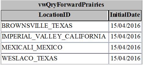
Each fall, soil core sampling is carried out across the Canadian prairies to assess wheat midge densities and parasitism levels of the overwintering cocoon stage.  Soil collected from wheat fields is collected then the samples are washed to retrieve the tiny cocoons, each measuring only ~2-3mm in diameter (Fig. 1).


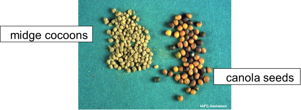
Figure 1. Wheat midge cocoon sizes (L) compared to canola seed (R).
After washing, each cocoon is carefully dissected under the microscope to determine if a parasitoid larva has attacked the wheat midge larval host.  The densities of the cocoons, and the percent parasitism by the biological control agents (Macroglenes penetrans, Platygaster sp., Euxestonotus error), are compiled and used to generate the geospatial forecast map below.  

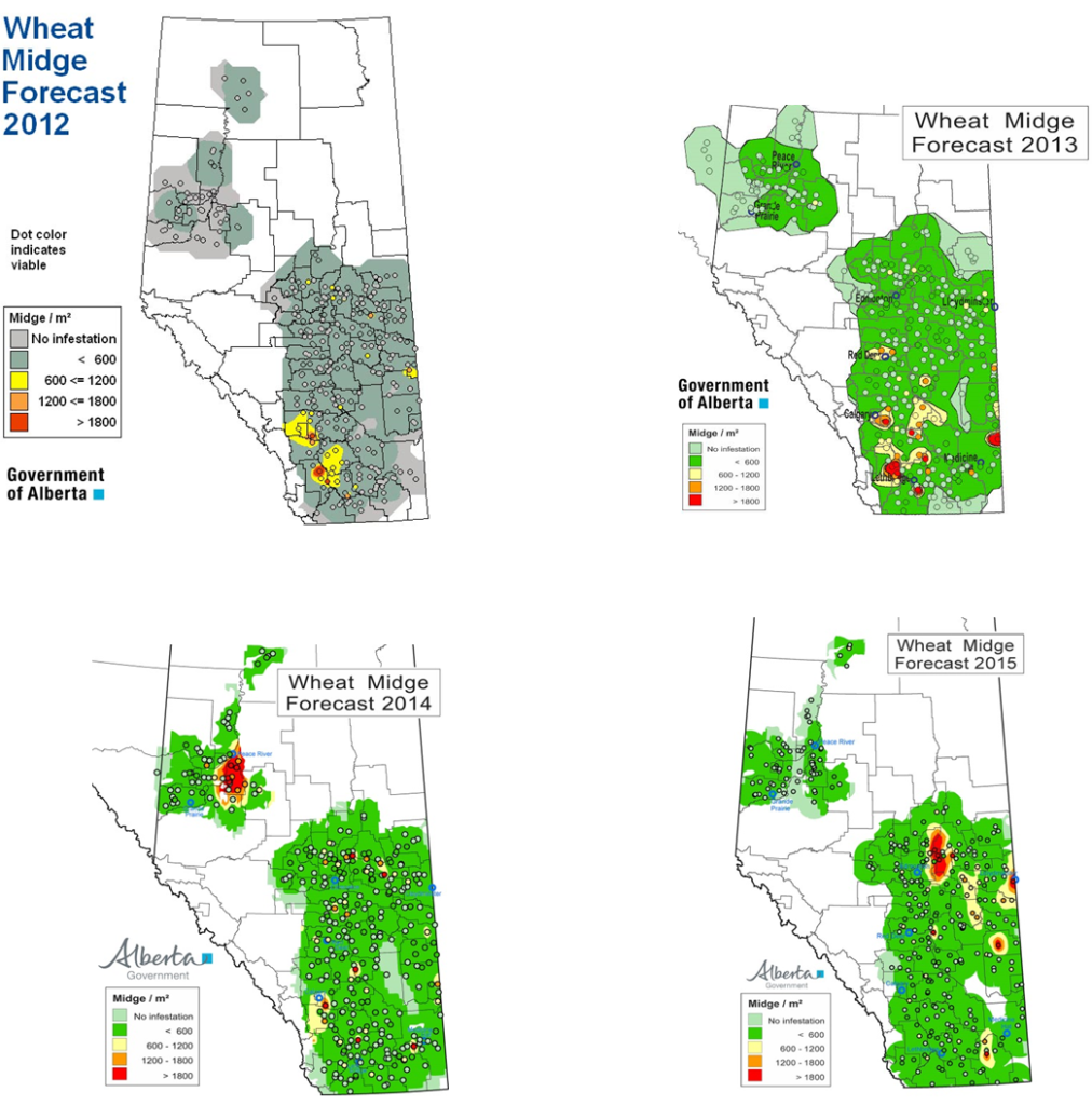
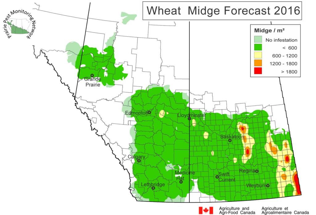
The Albertan 2017 wheat midge forecast is posted below (Fig. 2) and you can review previous maps for that province further down the page.  Be sure to review Alberta Agriculture & Forestry’s full wheat midge forecast map posting and how they conduct their survey by linking here.


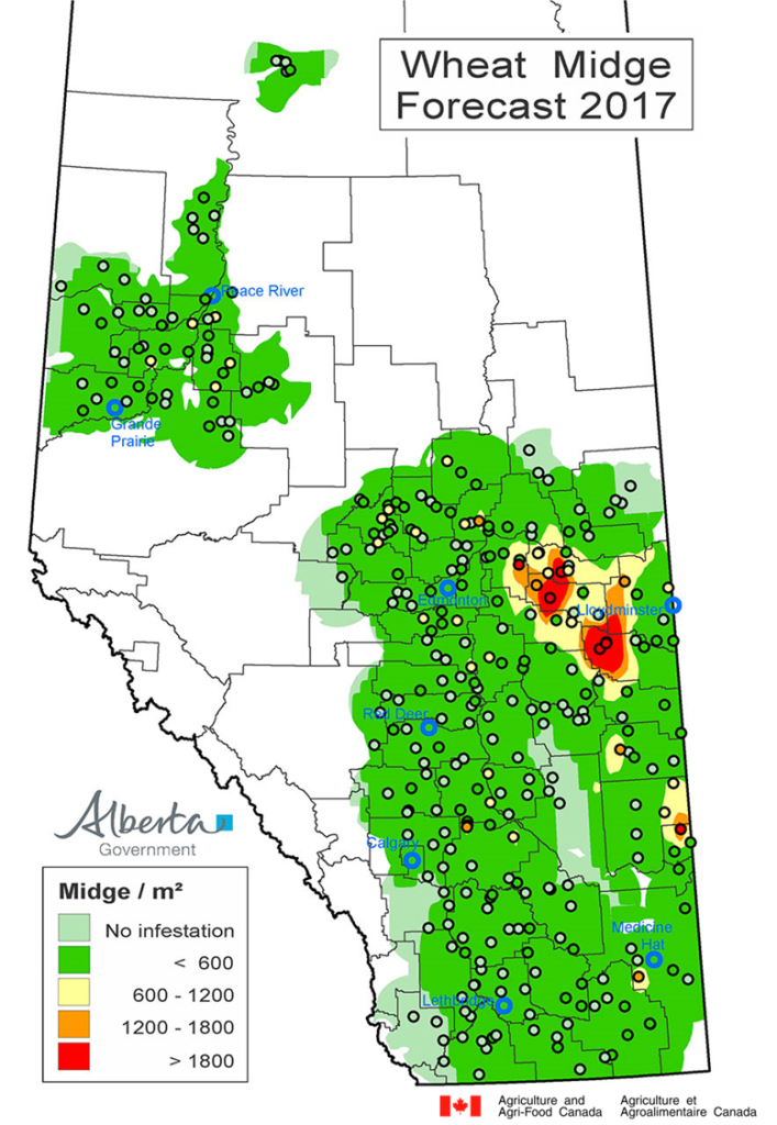
Figure 2.  Alberta wheat midge forecast map for 2017.


Additional information related to wheat midge biology and monitoring can be accessed by linking to your provincial fact sheet (Saskatchewan Agriculture or Alberta Agriculture & Forestry).  A review of wheat midge on the Canadian prairies was published by Elliott, Olfert, and Hartley in 2011.


More information about Wheat midge can be found by accessing the pages from the new “Field Crop and Forage Pests and their Natural Enemies in Western Canada: Identification and Field Guide”.  View ONLY the Wheat midge pages but remember the guide is available as a free downloadable document as both an English-enhanced or French-enhanced version.

2016 Cereal leaf beetle predictions

Cereal Leaf Beetles (Oulema melanopus) – Observed meteorological data (April 1-24, 2016) collected across the prairies was incorporated into a simulation model which calculates estimates of cereal leaf beetle (CLB) development stages for April 25-29, 2016.  The similuation model predicts the occurence of adults, eggs, and larval stages in the field and helps growers time their in-field scouting. Throughout June, outputs will be updated and growers will want to pay attention to the predicted appearance of larvae in order anticipate and time their in-field scouting.


For the week of April 25-29, 2016, CLB phenology is predicted to vary across the three provinces with phenology in Swan River MB predicted to be almost three weeks later than Lethbridge AB.  The following simulation outputs for Maple Creek SK, Lethbridge AB, Yorkton SK and Swan River MB are included below.


Fact sheets for CLB are published by the province of Alberta and by the Prairie Pest Monitoring Network.  Also access the Oulema melanopus page from the new “Field crop and forage pests and their natural enemies in western Canada – Identification and management field guide”.


.  

Wind Trajectories

THE WEEK OF APRIL 20-25, 2016:  Wind trajectory data processing by AAFC-Saskatoon Staff began in April.  Reverse Trajectories track arriving air masses back to their point of origin while Forward Trajectories predict favourable winds expected to arrive across the Canadian Prairies for the week of April 15-20, 2016:


Reverse trajectories (RT)
None to report for this period.


Forward Trajectories (FT)
For several weeks now, the wind model continues to predict that Forward Trajectories, arriving from southwest US and Mexico, will cross the prairies over the next few days. 

Review the 2016 Wind Trajectory Updates in pdf format.


Weather forecasts (7 day):
Winnipeg: https://weather.gc.ca/city/pages/mb-38_metric_e.html
Brandon: https://weather.gc.ca/city/pages/mb-52_metric_e.html
Saskatoon: https://weather.gc.ca/city/pages/sk-40_metric_e.html
Regina: https://weather.gc.ca/city/pages/sk-32_metric_e.html
Edmonton: https://weather.gc.ca/city/pages/ab-50_metric_e.html
Lethbridge: https://weather.gc.ca/city/pages/ab-30_metric_e.html

Grande Prairie: https://weather.gc.ca/city/pages/ab-31_metric_e.html

Grain News – Les Henry’s Annual Soil Moisture Map

On February 19, 2016, Grain News published Les Henry’s Annual Soil Moisture Map.


In the article, the map is described as,  “general conditions in general areas” but it estimates subsoil moisture from three inches to four feet. 


For reference, a copy of Les Henry’s map is included below but please link here to read the entire Grain News article.


Wind Trajectories

THE WEEK OF APRIL 15-20, 2016:  Wind trajectory data processing by AAFC-Saskatoon Staff began in April.  Reverse Trajectories track arriving air masses back to their point of origin while Forward Trajectories predict favourable winds expected to arrive across the Canadian Prairies for the week of April 15-20, 2016:

Reverse trajectories (RT)
None to report for this period.
Forward Trajectories (FT)
This week there are again three forward trajectories from southern USA and Mexico that are predicted to cross Alberta, Saskatchewan, and Manitoba over the next few days. 

In summary, the following table is a compilation of the number of Forward Trajectories predicted to have crossed the prairies to date, by point of origin.

Weather forecasts (7 day)
Winnipeg: https://weather.gc.ca/city/pages/mb-38_metric_e.html
Brandon: https://weather.gc.ca/city/pages/mb-52_metric_e.html
Saskatoon: https://weather.gc.ca/city/pages/sk-40_metric_e.html
Regina: https://weather.gc.ca/city/pages/sk-32_metric_e.html
Edmonton: https://weather.gc.ca/city/pages/ab-50_metric_e.html
Lethbridge: https://weather.gc.ca/city/pages/ab-30_metric_e.html
Grande Prairie: https://weather.gc.ca/city/pages/ab-31_metric_e.html

Wind Trajectories

THE WEEK OF APRIL 10-15, 2016:  Wind trajectory data processing by AAFC-Saskatoon Staff began in April.  Reverse Trajectories track arriving air masses back to their point of origin while Forward Trajectories predict favourable winds expected to arrive across the Canadian Prairies for the week of April 10-15, 2016:


Reverse trajectories (RT)
None to report for this period.


Forward Trajectories (FT)
The wind trajectory model continues to predict that Forward Trajectories, arriving from the US southwest and Mexico, will cross the prairies over the next few days.


Over the past weeks, the greatest number of Forward Trajectories (n=10) that were predicted to arrive on the prairies came from the Imperial Valley in California.

Wind trajectories

Wind trajectories Related to Diamondback Moth (DBM) and Aster Leafhopper Introductions
BACKGROUND:  Potential wind events capable of carrying insect pests from source areas in the USA can be identified by following trajectories for air parcels through time. High altitude air masses, originating from southern locations, frequently move northerly to Canadian destinations. Insect pest species such as Diamondback moth and Aster leafhoppers, traditionally unable to overwinter above the 49th parallel, can utilize these air masses in the spring to move north from Mexico and the United States (southern or Pacific northwest). Data acquired from Environment Canada is compiled by Olfert et al. (AAFC-Saskatoon) to track and model high altitude air masses in the spring with respect to potential introductions of insect pests onto the Canadian prairies. Each week, backward and forward trajectories are examined with respect to source and destination in the following manner. The forward trajectories are prognostic (5 days into the future) based on forecast wind fields while the backward trajectories are diagnostic and based on analyzed wind fields (5 days previous).
THE WEEK OF APRIL 7-11, 2016:  Wind trajectory data processing by AAFC-Saskatoon Staff began in April.  Reverse Trajectories track arriving air masses back to their point of origin while Forward Trajectories predict favourable winds expected to arrive across the Canadian Prairies for the week of April 7-11, 2016:

Again, this week there are three forward trajectories from southern USA and Mexico that are predicted to cross the prairies over the next few days.

Reverse trajectories (RT)
None to report this week.
Forward Trajectories (FT)
This week there are again three forward trajectories from southern USA and Mexico that are predicted to cross Alberta, Saskatchewan, and Manitoba over the next few days.  Those involved with Diamondback moth pheromone trap monitoring will want to consider deploying their traps.

Weather forecasts (7 day)
Winnipeg: https://weather.gc.ca/city/pages/mb-38_metric_e.html
Brandon: https://weather.gc.ca/city/pages/mb-52_metric_e.html
Saskatoon: https://weather.gc.ca/city/pages/sk-40_metric_e.html
Regina: https://weather.gc.ca/city/pages/sk-32_metric_e.html
Edmonton: https://weather.gc.ca/city/pages/ab-50_metric_e.html
Lethbridge: https://weather.gc.ca/city/pages/ab-30_metric_e.html
Grande Prairie: https://weather.gc.ca/city/pages/ab-31_metric_e.html

Wind trajectories

Wind trajectories Related to Diamondback Moth (DBM) and
Aster Leafhopper Introductions
BACKGROUND: 
Potential wind events capable of carrying insect pests from source areas
in the USA can be identified by following trajectories for air parcels through
time. High altitude air masses, originating from southern locations, frequently
move northerly to Canadian destinations. Insect pest species such as
Diamondback moth and Aster leafhoppers, traditionally unable to overwinter
above the 49th parallel, can utilize these air masses in the spring to move
north from Mexico and the United States (southern or Pacific northwest). Data
acquired from Environment Canada is compiled by Olfert et al. (AAFC-Saskatoon)
to track and model high altitude air masses in the spring with respect to
potential introductions of insect pests onto the Canadian prairies. Each week,
backward and forward trajectories are examined with respect to source and
destination in the following manner. The forward trajectories are prognostic (5
days into the future) based on forecast wind fields while the backward
trajectories are diagnostic and based on analyzed wind fields (5 days
previous).
THE WEEK OF APRIL 1-7, 2016:  Wind trajectory data processing by
AAFC-Saskatoon Staff began in April. 
Reverse Trajectories track arriving air masses back to their point of
origin while Forward Trajectories predict favourable winds expected to arrive
across the Canadian Prairies for the week of April 1-7, 2016:
Reverse trajectories (RT)
None to report this week.
Forward Trajectories (FT)
Trajectories crossing over California and Mexico are
projected to cross Alberta, Saskatchewan and Manitoba this week.  Those involved with Diamondback moth pheromone trap monitoring will want to consider deploying their traps.

Wind Trajectories

Wind
trajectories Related to Diamondback Moth (DBM) and Aster Leafhopper
Introductions to the Canadian Prairies in 2015

BACKGROUND:
  Potential wind events capable
of carrying insect pests from source areas in the USA can be identified by
following trajectories for air parcels through time. 
High altitude air masses, originating from southern
locations, frequently move northerly to Canadian destinations. Insect pest
species such as Diamondback moth and Aster leafhoppers, traditionally unable to
overwinter above the 49th parallel, can utilize these air masses in the spring
to move north from Mexico and the United States (southern or Pacific
northwest). 

Wind trajectory data processing by AAFC-Saskatoon Staff began in April.  Reverse
Trajectories
 track air masses arriving across the prairies back to
their point of origin.  Forward Trajectories predict
favourable winds expected to arrive across the Canadian Prairies.  

Updated: April 25-27, 2015
1. Reverse
trajectories
a. Pacific
Northwest (PNW) – 49 Reverse trajectories (RTs) were recorded on the Prairies
from northwest USA between April 25-27, 2015.
b. Mexico
and SW USA (SW) – Five locations (4 in MB and 1 in SK) reported RT’s that
originated from southern Texas over this same time frame.

2. Forward trajectories

Nine forward trajectories are predicted to cross the
prairies from Mexico and the USA over the next five days.

Wind Trajectories

Wind trajectories Related to Diamondback Moth (DBM) and Aster Leafhopper Introductions

Wind trajectory data processing by AAFC-Saskatoon Staff began in April.  Reverse Trajectories track air masses arriving across the prairies back to their point of origin.   Forward Trajectories predict favourable winds expected to arrive across the Canadian Prairies.  

Updated: April 21, 2015
1. Reverse trajectories
a. Pacific Northwest (PNW) – Nothing to report.
b. Mexico and SW USA (SW) – Nothing to report.
2. Forward trajectories

     Three forward trajectories, all from NW USA, are predicted to cross the prairies over the next five days.
Forward Trajectory Count Dates
Location ID
      Initial Date
BOZEMAN_MONTANA
21/04/2015
EASTERN_WASHINGTON   
21/04/2015
MOSCOW_IDAHO
21/04/2015

Wind Trajectories

Wind trajectories Related to Diamondback Moth (DBM) and Aster Leafhopper Introductions


Wind trajectory data processing by AAFC-Saskatoon Staff began in April.  Reverse Trajectories track air masses arriving across the prairies back to their point of origin.   Forward Trajectories predict favourable winds expected to arrive across the Canadian Prairies.  


Updated: April 15, 2015
1. Reverse trajectories
There
were 24 locations in western Canada that had winds originating from
northwestern USA on April 15, 2015. No reverse trajectories originating
from Mexico and southern USA.
2. Forward trajectories
Forward
wind trajectories, originating from northwestern USA and southern USA/Mexico,
are predicted to cross the prairies within the next five days.
Forward Trajectory Count Dates
Location ID
Count Dates
EASTERN_WASHINGTON
12
BOZEMAN_MONTANA
12
MOSCOW_IDAHO
11
SANTA_MARIA_CALIFORNIA
5
MANHATTAN_KANSAS
5
MEXICALI_MEXICO
2
IMPERIAL_VALLEY_CALIFORNIA
2
WESLACO_TEXAS
1
LOUISIANA
1

Wind Trajectories

Wind trajectories
Related to Diamondback Moth (DBM) and Aster Leafhopper Introductions

BACKGROUND:  Potential wind events capable of carrying insect
pests from source areas in the USA can be identified by following trajectories
for air parcels through time.
High altitude air masses, originating
from southern locations, frequently move northerly to Canadian destinations.
Insect pest species such as Diamondback moth and Aster leafhoppers,
traditionally unable to overwinter above the 49th parallel, can utilize these
air masses in the spring to move north from Mexico and the United States
(southern or Pacific northwest). Data acquired from Environment Canada is
compiled by Olfert et al. (AAFC-Saskatoon) to track and model high altitude air
masses in the spring with respect to potential introductions of insect pests
onto the Canadian prairies. Each week, backward and forward trajectories
are examined with respect to source and destination in the following manner.
The
forward trajectories are prognostic (5 days into the future) based on forecast
wind fields while the backward trajectories are diagnostic and based on
analyzed wind fields (5 days previous).


FOR THE WEEK OF APRIL 3-7, 2015:  Wind trajectory data processing by AAFC-Saskatoon Staff began in April.  Reverse Trajectories track arriving air masses back to their point of origin while Forward Trajectories predict favourable winds expected to arrive across the Canadian Prairies for the week of April 3-7, 2015:


Reverse trajectories (RT) 
Pacific
Northwest (PNW) – The number of reverse trajectories from Prairie locations
with links to the PNW continues to be relatively high. the following 25 locations had RT’s,
originating from the PNW, that crossed the prairies on April 1 and 2, 2015. Of
particular interest were the northern AB locations reported for April
7.


Reverse Trajectories Originating from PNW Arriving at Prairie Locations
Location ID
Arriving Date
(dd-m-year)
Latitude
Longitude
WANHAM_AB
07/04/2015
55.7
-118.4
VEGREVILLE_AB
07/04/2015
53.5
-112
SEDGEWICK_AB
07/04/2015
52.8
-111.7
RYCROFT_AB
07/04/2015
55.8
-118.7
REGINA_SK
07/04/2015
50.5
-104.5
PROVOST_AB
07/04/2015
52.4
-110.3
OLDS_AB
07/04/2015
51.8
-114.1
LETHBRIDGE_AB
07/04/2015
49.7
-112.8
KINDERSLEY_SK
07/04/2015
51.5
-109.1
GRENFELL_SK
07/04/2015
50.4
-102.9
GRANDE_PRAIRIE_AB
07/04/2015
55.2
-118.8
GAINSBOROUGH_SK
07/04/2015
49.2
-101.4
FORT_VERMILION_AB
07/04/2015
58.4
-116
BEISEKER_AB
07/04/2015
51.4
-113.5
ANDREW_AB
07/04/2015
53.9
-112.3
VEGREVILLE_AB
06/04/2015
53.5
-112
SEDGEWICK_AB
06/04/2015
52.8
-111.7
OLDS_AB
06/04/2015
51.8
-114.1
LETHBRIDGE_AB
06/04/2015
49.7
-112.8
GRANDE_PRAIRIE_AB
06/04/2015
55.2
-118.8
BEISEKER_AB
06/04/2015
51.4
-113.5
LETHBRIDGE_AB
05/04/2015
49.7
-112.8
KINDERSLEY_SK
05/04/2015
51.5
-109.1
BEISEKER_AB
05/04/2015
51.4
-113.5
LETHBRIDGE_AB
04/04/2015
49.7
-112.8


Forward Trajectories (FT)
Forward trajectories originating from the following locations are predicted to cross the prairies within the next five days:

  Forward Trajectory source locations predicted to cross the Canadian prairies  
Location ID
Initial Date
(dd-m-year)
BOZEMAN_MONTANA
07/04/2015
EASTERN_WASHINGTON
07/04/2015
IMPERIAL_VALLEY_CALIFORNIA
07/04/2015
MEXICALI_MEXICO
07/04/2015
MOSCOW_IDAHO
07/04/2015
BOZEMAN_MONTANA
06/04/2015
EASTERN_WASHINGTON
06/04/2015
LOUISIANA
06/04/2015
MANHATTAN_KANSAS
06/04/2015
MOSCOW_IDAHO
06/04/2015
SANTA_MARIA_CALIFORNIA
06/04/2015
BOZEMAN_MONTANA
05/04/2015
EASTERN_WASHINGTON
05/04/2015
MANHATTAN_KANSAS
05/04/2015
EASTERN_WASHINGTON
04/04/2015
MANHATTAN_KANSAS
04/04/2015
MOSCOW_IDAHO
04/04/2015
EASTERN_WASHINGTON
03/04/2015
MOSCOW_IDAHO
03/04/2015
The April 6 forward trajectory from Santa Maria, California, is
predicted to cross over southern Alberta on April 11. The forward trajectory from
Mexicali should cross southern Manitoba about April 8. The Imperial Valley trajectory is
predicted to cross southern Manitoba on April 9. 
Though the prairies were forecasted to expect snow (April 7), conditions are
predicted to warm up over the next few days.
Forecast for Lethbridge:
Forecast for Winnipeg: