2016 Cereal leaf beetle predictions

Owen Olfert, Ross Weiss, David Giffen and Erl Svendsen
Categories
Forecast Maps

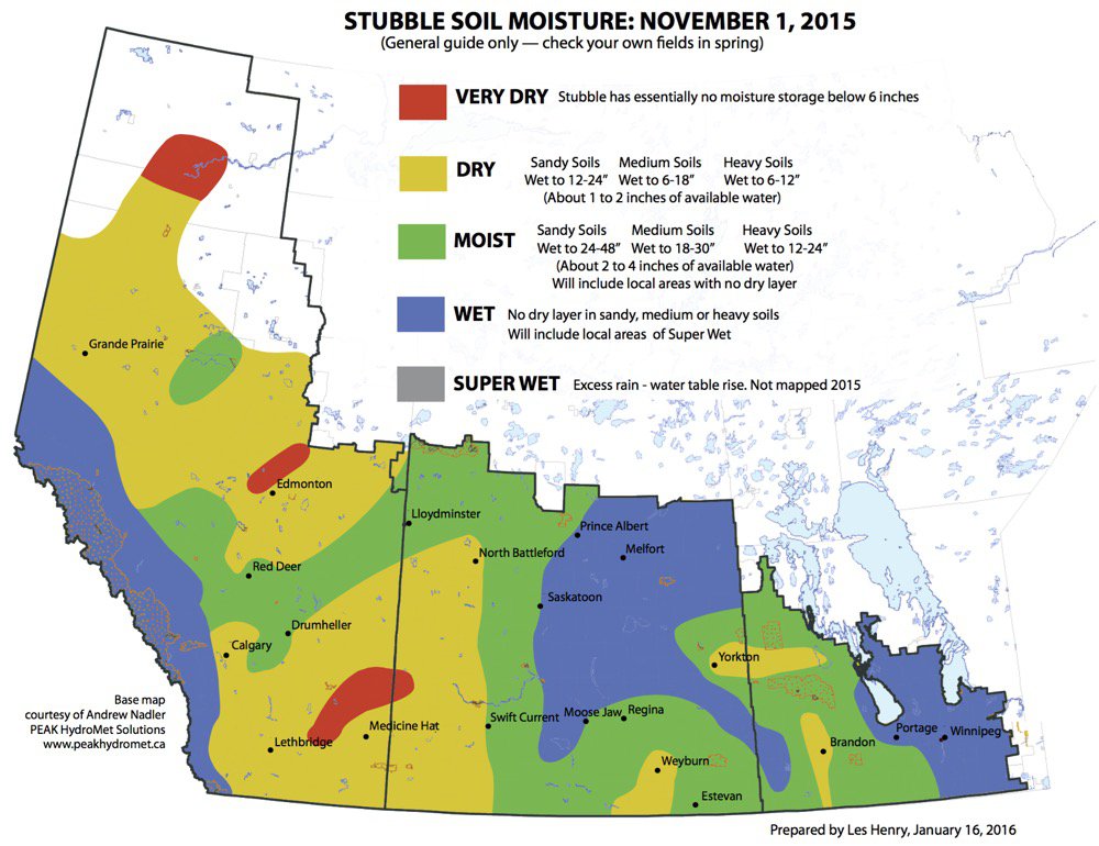
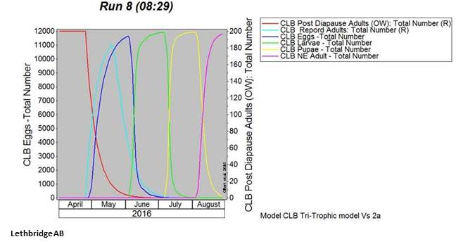
Cereal Leaf Beetles (Oulema melanopus) – Observed meteorological data (April 1-24, 2016) collected across the prairies was incorporated into a simulation model which calculates estimates of cereal leaf beetle (CLB) development stages for April 25-29, 2016.  The similuation model predicts the occurence of adults, eggs, and larval stages in the field and helps growers time their in-field scouting. Throughout June, outputs will be updated and growers will want to pay attention to the predicted appearance of larvae in order anticipate and time their in-field scouting.


For the week of April 25-29, 2016, CLB phenology is predicted to vary across the three provinces with phenology in Swan River MB predicted to be almost three weeks later than Lethbridge AB.  The following simulation outputs for Maple Creek SK, Lethbridge AB, Yorkton SK and Swan River MB are included below.


Fact sheets for CLB are published by the province of Alberta and by the Prairie Pest Monitoring Network.  Also access the Oulema melanopus page from the new “Field crop and forage pests and their natural enemies in western Canada – Identification and management field guide”.


.  

SHARE THIS POST

Wind Trajectories

Ross Weiss, Owen Olfert, Serge Trudel and prairiepest_admin
Categories
Forecast Maps

THE WEEK OF APRIL 20-25, 2016:  Wind trajectory data processing by AAFC-Saskatoon Staff began in April.  Reverse Trajectories track arriving air masses back to their point of origin while Forward Trajectories predict favourable winds expected to arrive across the Canadian Prairies for the week of April 15-20, 2016:


Reverse trajectories (RT)
None to report for this period.


Forward Trajectories (FT)
For several weeks now, the wind model continues to predict that Forward Trajectories, arriving from southwest US and Mexico, will cross the prairies over the next few days. 

Review the 2016 Wind Trajectory Updates in pdf format.


Weather forecasts (7 day):
Winnipeg: https://weather.gc.ca/city/pages/mb-38_metric_e.html
Brandon: https://weather.gc.ca/city/pages/mb-52_metric_e.html
Saskatoon: https://weather.gc.ca/city/pages/sk-40_metric_e.html
Regina: https://weather.gc.ca/city/pages/sk-32_metric_e.html
Edmonton: https://weather.gc.ca/city/pages/ab-50_metric_e.html
Lethbridge: https://weather.gc.ca/city/pages/ab-30_metric_e.html

Grande Prairie: https://weather.gc.ca/city/pages/ab-31_metric_e.html

SHARE THIS POST

Wind Trajectories

Ross Weiss, Owen Olfert, Serge Trudel and prairiepest_admin
Categories
Forecast Maps
THE WEEK OF APRIL 15-20, 2016:  Wind trajectory data processing by AAFC-Saskatoon Staff began in April.  Reverse Trajectories track arriving air masses back to their point of origin while Forward Trajectories predict favourable winds expected to arrive across the Canadian Prairies for the week of April 15-20, 2016:

Reverse trajectories (RT)
None to report for this period.
Forward Trajectories (FT)
This week there are again three forward trajectories from southern USA and Mexico that are predicted to cross Alberta, Saskatchewan, and Manitoba over the next few days. 

In summary, the following table is a compilation of the number of Forward Trajectories predicted to have crossed the prairies to date, by point of origin.

Weather forecasts (7 day)
Winnipeg: https://weather.gc.ca/city/pages/mb-38_metric_e.html
Brandon: https://weather.gc.ca/city/pages/mb-52_metric_e.html
Saskatoon: https://weather.gc.ca/city/pages/sk-40_metric_e.html
Regina: https://weather.gc.ca/city/pages/sk-32_metric_e.html
Edmonton: https://weather.gc.ca/city/pages/ab-50_metric_e.html
Lethbridge: https://weather.gc.ca/city/pages/ab-30_metric_e.html
Grande Prairie: https://weather.gc.ca/city/pages/ab-31_metric_e.html

SHARE THIS POST

Wind Trajectories

Ross Weiss, Owen Olfert, Serge Trudel and prairiepest_admin
Categories
Forecast Maps

THE WEEK OF APRIL 10-15, 2016:  Wind trajectory data processing by AAFC-Saskatoon Staff began in April.  Reverse Trajectories track arriving air masses back to their point of origin while Forward Trajectories predict favourable winds expected to arrive across the Canadian Prairies for the week of April 10-15, 2016:


Reverse trajectories (RT)
None to report for this period.


Forward Trajectories (FT)
The wind trajectory model continues to predict that Forward Trajectories, arriving from the US southwest and Mexico, will cross the prairies over the next few days.


Over the past weeks, the greatest number of Forward Trajectories (n=10) that were predicted to arrive on the prairies came from the Imperial Valley in California.

SHARE THIS POST

Wind trajectories

Ross Weiss, Owen Olfert, Serge Trudel and prairiepest_admin
Categories
Forecast Maps
Wind trajectories Related to Diamondback Moth (DBM) and Aster Leafhopper Introductions
BACKGROUND:  Potential wind events capable of carrying insect pests from source areas in the USA can be identified by following trajectories for air parcels through time. High altitude air masses, originating from southern locations, frequently move northerly to Canadian destinations. Insect pest species such as Diamondback moth and Aster leafhoppers, traditionally unable to overwinter above the 49th parallel, can utilize these air masses in the spring to move north from Mexico and the United States (southern or Pacific northwest). Data acquired from Environment Canada is compiled by Olfert et al. (AAFC-Saskatoon) to track and model high altitude air masses in the spring with respect to potential introductions of insect pests onto the Canadian prairies. Each week, backward and forward trajectories are examined with respect to source and destination in the following manner. The forward trajectories are prognostic (5 days into the future) based on forecast wind fields while the backward trajectories are diagnostic and based on analyzed wind fields (5 days previous).
THE WEEK OF APRIL 7-11, 2016:  Wind trajectory data processing by AAFC-Saskatoon Staff began in April.  Reverse Trajectories track arriving air masses back to their point of origin while Forward Trajectories predict favourable winds expected to arrive across the Canadian Prairies for the week of April 7-11, 2016:

Again, this week there are three forward trajectories from southern USA and Mexico that are predicted to cross the prairies over the next few days.

Reverse trajectories (RT)
None to report this week.
Forward Trajectories (FT)
This week there are again three forward trajectories from southern USA and Mexico that are predicted to cross Alberta, Saskatchewan, and Manitoba over the next few days.  Those involved with Diamondback moth pheromone trap monitoring will want to consider deploying their traps.

Weather forecasts (7 day)
Winnipeg: https://weather.gc.ca/city/pages/mb-38_metric_e.html
Brandon: https://weather.gc.ca/city/pages/mb-52_metric_e.html
Saskatoon: https://weather.gc.ca/city/pages/sk-40_metric_e.html
Regina: https://weather.gc.ca/city/pages/sk-32_metric_e.html
Edmonton: https://weather.gc.ca/city/pages/ab-50_metric_e.html
Lethbridge: https://weather.gc.ca/city/pages/ab-30_metric_e.html
Grande Prairie: https://weather.gc.ca/city/pages/ab-31_metric_e.html

SHARE THIS POST

Wind trajectories

Ross Weiss, Owen Olfert, Serge Trudel and prairiepest_admin
Categories
Forecast Maps
Wind trajectories Related to Diamondback Moth (DBM) and
Aster Leafhopper Introductions
BACKGROUND: 
Potential wind events capable of carrying insect pests from source areas
in the USA can be identified by following trajectories for air parcels through
time. High altitude air masses, originating from southern locations, frequently
move northerly to Canadian destinations. Insect pest species such as
Diamondback moth and Aster leafhoppers, traditionally unable to overwinter
above the 49th parallel, can utilize these air masses in the spring to move
north from Mexico and the United States (southern or Pacific northwest). Data
acquired from Environment Canada is compiled by Olfert et al. (AAFC-Saskatoon)
to track and model high altitude air masses in the spring with respect to
potential introductions of insect pests onto the Canadian prairies. Each week,
backward and forward trajectories are examined with respect to source and
destination in the following manner. The forward trajectories are prognostic (5
days into the future) based on forecast wind fields while the backward
trajectories are diagnostic and based on analyzed wind fields (5 days
previous).
THE WEEK OF APRIL 1-7, 2016:  Wind trajectory data processing by
AAFC-Saskatoon Staff began in April. 
Reverse Trajectories track arriving air masses back to their point of
origin while Forward Trajectories predict favourable winds expected to arrive
across the Canadian Prairies for the week of April 1-7, 2016:
Reverse trajectories (RT)
None to report this week.
Forward Trajectories (FT)
Trajectories crossing over California and Mexico are
projected to cross Alberta, Saskatchewan and Manitoba this week.  Those involved with Diamondback moth pheromone trap monitoring will want to consider deploying their traps.
SHARE THIS POST

SHARE THIS POST